Cotabato Trench

Last updated

Philippines location map (Mindanao).svg
Red pog.svg
2005
Red pog.svg
2009
Red pog.svg
2014
Red pog.svg
2017
Red pog.svg
2019
For recent Philippine earthquakes, a third of the largest ones (M ≥ 6.3) since 2001 have been near the Cotabato Trench.

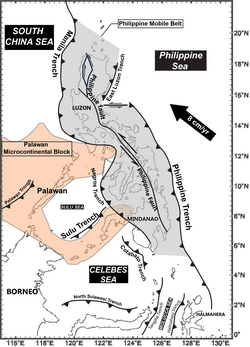
The Cotabato Trench is an oceanic trench in the Pacific Ocean, off the southwestern coast of Mindanao in the Philippines. Along this trench the oceanic crust of the Sunda Plate beneath the Celebes Sea is being subducted beneath the Philippines Mobile Belt. It forms part of a linked set of trenches along the western side of the Philippines formed over east-dipping subduction zones, including the Manila Trench and the Negros Trench. [1] At its northern end the rate of convergence across this boundary is about 100 mm per year. [2] It is a relatively young structure, forming during the late Miocene to Pliocene. [3] This age is consistent with the estimated age of the sedimentary rocks in the accretionary wedge associated with the trench and the age of adakitic arc rocks on Mindanao thought to date the onset of subduction. [4]

Contents

Seismicity

Main tectonic structures around the Philippines PhilippineMobileBelt007.jpg
Main tectonic structures around the Philippines

The trench is associated with large megathrust earthquakes, including the 1918 Celebes Sea earthquake (M 8.3), the 1976 Moro Gulf earthquake (M 8.0) and the 2002 Mindanao earthquake (M 7.5). [5] [2]

Tsunami hazard

The Cotabato Trench is one of the main structure around the Philippines likely to be associated with tsunamigenic earthquakes. The tsunami generated by the 1976 earthquake caused about 4,000 deaths on Mindanao. Modelling of likely further tsunamis along the Cotabato Trench suggests that run-ups of several metres are likely for future earthquakes similar in size to the 1976 event. [6]

Related Research Articles

<span class="mw-page-title-main">Subduction</span> A geological process at convergent tectonic plate boundaries where one plate moves under the other

Subduction is a geological process in which the oceanic lithosphere and some continental lithosphere is recycled into the Earth's mantle at convergent boundaries. Where the oceanic lithosphere of a tectonic plate converges with the less dense lithosphere of a second plate, the heavier plate dives beneath the second plate and sinks into the mantle. A region where this process occurs is known as a subduction zone, and its surface expression is known as an arc-trench complex. The process of subduction has created most of the Earth's continental crust. Rates of subduction are typically measured in centimeters per year, with rates of convergence as high as 11 cm/year.

<span class="mw-page-title-main">Convergent boundary</span> Region of active deformation between colliding tectonic plates

A convergent boundary is an area on Earth where two or more lithospheric plates collide. One plate eventually slides beneath the other, a process known as subduction. The subduction zone can be defined by a plane where many earthquakes occur, called the Wadati–Benioff zone. These collisions happen on scales of millions to tens of millions of years and can lead to volcanism, earthquakes, orogenesis, destruction of lithosphere, and deformation. Convergent boundaries occur between oceanic-oceanic lithosphere, oceanic-continental lithosphere, and continental-continental lithosphere. The geologic features related to convergent boundaries vary depending on crust types.

<span class="mw-page-title-main">Australian Plate</span> Major tectonic plate separated from Indo-Australian Plate about 3 million years ago

The Australian Plate is a major tectonic plate in the eastern and, largely, southern hemispheres. Originally a part of the ancient continent of Gondwana, Australia remained connected to India and Antarctica until approximately 100 million years ago when India broke away and began moving north. Australia and Antarctica had begun rifting by 96 million years ago and completely separated a while after this, some believing as recently as 45 million years ago, but most accepting presently that this had occurred by 60 million years ago.

Megathrust earthquakes occur at convergent plate boundaries, where one tectonic plate is forced underneath another. The earthquakes are caused by slip along the thrust fault that forms the contact between the two plates. These interplate earthquakes are the planet's most powerful, with moment magnitudes (Mw) that can exceed 9.0. Since 1900, all earthquakes of magnitude 9.0 or greater have been megathrust earthquakes.

<span class="mw-page-title-main">Ryukyu Trench</span> Oceanic trench along the southeastern edge of Japans Ryukyu Islands in the Pacific Ocean

The Ryukyu Trench, also called Nansei-Shotō Trench, is a 1398 km (868 mi) long oceanic trench located along the southeastern edge of Japan's Ryukyu Islands in the Philippine Sea in the Pacific Ocean, between northeastern Taiwan and southern Japan. The trench has a maximum depth of 7460 m (24,476 ft). The trench is the result of oceanic crust of the Philippine Plate obliquely subducting beneath the continental crust of the Eurasian Plate at a rate of approximately 52 mm/yr. In conjunction with the adjacent Nankai Trough to the northeast, subduction of the Philippine plate has produced 34 volcanoes. The largest earthquake to have been recorded along the Ryukyu Trench, the 1968 Hyūga-nada earthquake, was magnitude 7.5 and occurred along the northernmost part of the trench on 1 April 1968. This earthquake also produced a tsunami.

<span class="mw-page-title-main">Manila Trench</span> Oceanic trench in the South China Sea, west of Luzon and Mindoro in the Philippines

The Manila Trench is an oceanic trench in the Pacific Ocean, located west of the islands of Luzon and Mindoro in the Philippines. The trench reaches a depth of about 5,400 metres (17,700 ft), in contrast with the average depth of the South China Sea of about 1,500 metres (4,900 ft). It is created by subduction, in which the Sunda Plate is subducting under the Philippine Mobile Belt, producing this almost N-S trending trench. The convergent boundary is terminated to the north by the Taiwan collision zone, and to the south by the Mindoro terrane. It is an area pervaded by negative gravity anomalies.

<span class="mw-page-title-main">Geology of Japan</span> Overview of the geology of Japan

The islands of Japan are primarily the result of several large ocean movements occurring over hundreds of millions of years from the mid-Silurian to the Pleistocene, as a result of the subduction of the Philippine Sea Plate beneath the continental Amurian Plate and Okinawa Plate to the south, and subduction of the Pacific Plate under the Okhotsk Plate to the north.

<span class="mw-page-title-main">Philippine Trench</span> Submarine trench to the east of the Philippines in the Pacific Ocean

The Philippine Trench is a submarine trench to the east of the Philippines. The trench is located in the Philippine sea of the western North Pacific Ocean and continues NNW-SSE. It has a length of approximately 1,320 kilometres and a width of about 30 km (19 mi) from the center of the Philippine island of Luzon trending southeast to the northern Maluku island of Halmahera in Indonesia. At its deepest point, the trench reaches 10,540 meters.

<span class="mw-page-title-main">Izu–Bonin–Mariana Arc</span> Convergent boundary in Micronesia

The Izu–Bonin–Mariana (IBM) arc system is a tectonic plate convergent boundary in Micronesia. The IBM arc system extends over 2800 km south from Tokyo, Japan, to beyond Guam, and includes the Izu Islands, the Bonin Islands, and the Mariana Islands; much more of the IBM arc system is submerged below sealevel. The IBM arc system lies along the eastern margin of the Philippine Sea Plate in the Western Pacific Ocean. It is the site of the deepest gash in Earth's solid surface, the Challenger Deep in the Mariana Trench.

<span class="mw-page-title-main">1976 Moro Gulf earthquake</span> Earthquake in the Philippines

The 1976 Moro Gulf earthquake and tsunami occurred on August 17, 1976, at 00:11 local time near the islands of Mindanao and Sulu, in the Philippines. It measured 8.0 on the moment magnitude scale occurring at a depth of 20 km (12 mi). The earthquake was accompanied by a destructive tsunami that resulted in a majority of the estimated 5,000 to 8,000 fatalities. It was the deadliest and strongest earthquake in the Philippines in 58 years since the 1918 Celebes Sea earthquake.

<span class="mw-page-title-main">Molucca Sea Plate</span> Small fully subducted tectonic plate near Indonesia

Located in the western Pacific Ocean near Indonesia, the Molucca Sea Plate has been classified by scientists as a fully subducted microplate that is part of the Molucca Sea Collision Complex. The Molucca Sea Plate represents the only known example of divergent double subduction (DDS), which describes the subduction on both sides of a single oceanic plate.

<span class="mw-page-title-main">Philippine Mobile Belt</span> Tectonic boundary

In the geology of the Philippines, the Philippine Mobile Belt is a complex portion of the tectonic boundary between the Eurasian Plate and the Philippine Sea Plate, comprising most of the country of the Philippines. It includes two subduction zones, the Manila Trench to the west and the Philippine Trench to the east, as well as the Philippine Fault System. Within the Belt, a number of crustal blocks or microplates which have been shorn off the adjoining major plates are undergoing massive deformation.

<span class="mw-page-title-main">2002 Mindanao earthquake</span> M-7.5 earthquake in Philippines

The 2002 Mindanao earthquake struck the Philippines at 05:16 Philippine Standard Time on March 6. The world's sixth most powerful earthquake of the year, it registered a magnitude of 7.5 and was a megathrust earthquake. It originated near the Cotabato Trench, a zone of deformation situated between the Philippine Sea Plate and the Sunda Plate, and occurred very near to the Philippines' strongest earthquake for the 20th century, the 1918 Celebes Sea earthquake.

The 1897 Mindanao earthquakes occurred on September 20, 1897, at 19:06 UTC and September 21, 1897, at 05:12 UTC. The estimated epicentres of the two earthquakes are identical, lying just off the southwestern coast of Mindanao in the Philippines, south of Basilan island. The earthquakes were originally given estimated magnitudes of 8.6 and 8.7 on the surface wave magnitude scale by Charles Richter, but these were revised downwards by Katsuyuki Abe to 7.4 and 7.5 Ms, respectively. Contemporary reports noted that with few exceptions, all the masonry buildings in Zamboanga and Basilan were left in ruins.

<span class="mw-page-title-main">1918 Celebes Sea earthquake</span> Earthquake in the Philippines

The 1918 Celebes Sea earthquake occurred on August 15 at 12:18 UTC near the Moro Gulf coast of Mindanao. It had a magnitude of 8.3 on the moment magnitude scale and a maximum perceived intensity of X (Extreme) on the Mercalli intensity scale.

<span class="mw-page-title-main">Aleutian subduction zone</span> Convergence boundary between the North American Plate and the Pacific Plate

The Aleutian subduction zone is a 2,500 mi (4,000 km) long convergent boundary between the North American Plate and the Pacific Plate, that extends from the Alaska Range to the Kamchatka Peninsula. Here, the Pacific Plate is being subducted underneath the North American Plate and the rate of subduction changes from west to east from 7.5 to 5.1 cm per year. The Aleutian subduction zone includes two prominent features, the Aleutian Arc and the Aleutian Trench. The Aleutian Arc was created via volcanic eruptions from dehydration of the subducting slab at ~100 km depth. The Aleutian Trench is a narrow and deep morphology that occurs between the two converging plates as the subducting slab dives beneath the overriding plate.

<span class="mw-page-title-main">Subduction tectonics of the Philippines</span>

The subduction tectonics of the Philippines is the control of geology over the Philippine archipelago. The Philippine region is seismically active and has been progressively constructed by plates converging towards each other in multiple directions. The region is also known as the Philippine Mobile Belt due to its complex tectonic setting.

<span class="mw-page-title-main">East Luzon Trough</span> Oceanic trench

The East Luzon Trough is an oceanic trench north of the Philippine Trench and east of the island of Luzon. The trench is located near the Philippine orogeny and located in the southeastern region of the Philippine Sea Plate. The depth of the trough is 5,700 meters. The East Luzon Trough formed during the Eocene and Oligocene epoch, 40–24 million years ago.

<span class="mw-page-title-main">1867 Keelung earthquake</span> Earthquake and tsunami affecting the northern coast of Taiwan

The 1867 Keelung earthquake occurred off the northern coast of Taiwan on the morning of December 18 with a magnitude of 7.0. It produced strong shaking that seriously damaged the cities of Keelung and Taipei. A tsunami, thought to be the only confirmed destructive of its kind in Taiwan, drowned hundreds and had a run-up exceeding 15 m (49 ft). The total death toll was estimated to be 580 while more than 100 were injured. It was followed by aftershocks that were felt on average ten times a day.

References

  1. Wu, W.N.; Lo, C.-L.; Lin, J.-Y. (2017). "Spatial variations of the crustal stress field in the Philippine region from inversion of earthquake focal mechanisms and their tectonic implications". Journal of Asian Earth Sciences. 142: 109–118. Bibcode:2017JAESc.142..109W. doi:10.1016/j.jseaes.2017.01.036.
  2. 1 2 ANSS. "Mindanao 2002". Comprehensive Catalog. U.S. Geological Survey.
  3. Jego, S.; Maury, R.C.; Polve, M.; Yumul, G.P. Jr.; Bellon, H.; Tamayo, R.A. Jr.; Cotton, J. (2005). "Geochemistry of Adakites from the Philippines: Constraints on Their Origins". Resource Geology. 55 (3): 161–185. doi: 10.1111/j.1751-3928.2005.tb00239.x .
  4. Schlüter, H.U.; Block, M.; Hinz, K.; Neben, S.; Seidel, D.; Djajdihardja, Y. (2001). "Neogene sediment thickness and Miocene basin-floor fan systems of the Celebes Sea". Marine and Petroleum Geology. 18 (7): 849–861. doi:10.1016/S0264-8172(01)00027-7.
  5. Stewart, G.S.; Cohn, S.N. (1979). "The 1976 August 16, Mindanao , Philippine earthquake (Ms = 7.8) - evidence for a subduction zone south of Mindanao". Geophysical Journal of the Royal Astronomical Society. 57 (1): 51–65. Bibcode:1979GeoJ...57...51S. CiteSeerX   10.1.1.926.8672 . doi:10.1111/j.1365-246X.1979.tb03771.x.
  6. Løvholt, F.; Kühn, D.; Bungum, H.; Harbitz, C.B.; Glimsdal, S. (2012). "Historical tsunamis and present tsunami hazard in eastern Indonesia and the southern Philippines" (PDF). Journal of Geophysical Research. 117 (B9): B09310. Bibcode:2012JGRB..117.9310L. doi:10.1029/2012JB009425.

6°00′N123°36′E / 6.0°N 123.6°E / 6.0; 123.6