The geography of Alabama describes a state in the Southeastern United States in North America. It extends from high mountains to low valleys and sandy beaches. Alabama is 30th in size and borders four U.S. states: Mississippi, Tennessee, Georgia, and Florida. It also borders the Gulf of Mexico.

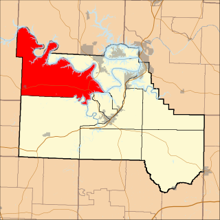
Carter County is a county in the Ozarks of Missouri. At the 2020 census, it had a population of 5,202. The largest city and county seat is Van Buren. The county was officially organized on March 10, 1859, and is named after Zimri A. Carter, a pioneer settler who came to Missouri from South Carolina in 1812.
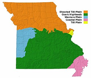
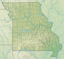
Missouri, a state near the geographical center of the United States, has three distinct physiographic divisions:

The Ozarks, also known as the Ozark Mountains, Ozark Highlands or Ozark Plateau, is a physiographic region in the U.S. states of Missouri, Arkansas, Oklahoma and the extreme southeastern corner of Kansas. The Ozarks cover a significant portion of northern Arkansas and most of the southern half of Missouri, extending from Interstate 40 in central Arkansas to Interstate 70 in central Missouri.
Landforms are categorized by characteristic physical attributes such as their creating process, shape, elevation, slope, orientation, rock exposure, and soil type.
The Ozark – St. Francis National Forest is a United States National Forest that is located in the state of Arkansas. It is composed of two separate forests, Ozark National Forest in the Ozark Mountains; and St. Francis National Forest on Crowley's Ridge. Each forest has distinct biological, topographical, and geological differences.

The Ouachita Mountains, simply referred to as the Ouachitas, are a mountain range in western Arkansas and southeastern Oklahoma. They are formed by a thick succession of highly deformed Paleozoic strata constituting the Ouachita Fold and Thrust Belt, one of the important orogenic belts of North America. The Ouachitas continue in the subsurface to the northeast, where they make a poorly understood connection with the Appalachians and to the southwest, where they join with the Marathon uplift area of West Texas. Together with the Ozark Plateaus, the Ouachitas form the U.S. Interior Highlands. The highest natural point is Mount Magazine at 2,753 feet (839 m).
The Missouri Coteau, or Missouri Plateau, is a large plateau that stretches along the eastern side of the valley of the Missouri River in central North Dakota and north-central South Dakota in the United States. In the Canadian provinces of Saskatchewan and Alberta this physiographic region is classified as the Uplands Missouri Coteau, which is a part of the Great Plains Province or Alberta Plateau Region, which extends across the southwest corner of the province of Saskatchewan as well as the southeast corner of the province of Alberta. Historically, in Canada the area was known as the Palliser's Triangle and regarded as an extension of the Great American Desert and unsuitable for agriculture and thus designated by Canadian geographer and explorer John Palliser. The terrain of the Missouri Coteau features low hummocky, undulating, rolling hills, potholes, and grasslands. Apart from being a geographical area, the Missouri Coteau also has a cultural connection to the people of the area, the Métis people of South Dakota, along with other Indigenous groups. The history of this plateau is large, and the Missouri Coteau has a significance to these people.

Rockbridge is an unincorporated community in northern Ozark County, Missouri, United States. It is the site of an old mill on spring fed Spring Creek, a tributary of Bryant Creek, which still houses the post office. It lies twelve miles north of Gainesville on Missouri Route N, approximately one and one-half miles north of Route 95. The narrow valley floor is only about 650 feet (200 m) wide and at an elevation of 770 feet (230 m) and the Ozark ridges on either side are 200 to 250 feet higher.

The Salt River is a 150-mile-long (240 km) river in the U.S. state of Kentucky that drains 2,920 square miles (7,600 km2). It begins near Parksville, Kentucky, rising from the north slope of Persimmon Knob south of KY 300 between Alum Springs and Wilsonville, and ends at the Ohio River near West Point. Taylorsville Lake is formed from the Salt River, and Guist Creek Lake is also in its drainage basin.

The central U.S. hardwood forests comprise a temperate broadleaf and mixed forests ecoregion in the Eastern United States, as defined by the World Wildlife Fund. It has one of the most diverse herbaceous plant floras of ecoregions in North America.

The Upland South and Upper South are two overlapping cultural and geographic subregions in the inland part of the Southern United States. They differ from the Deep South and Atlantic coastal plain by terrain, history, economics, demographics, and settlement patterns.
Adair Township is one of eleven townships in Camden County, Missouri, USA. At the 2010 census, its population was 5,062.

The geography of Arkansas varies widely. The state is covered by mountains, river valleys, forests, lakes, and bayous in addition to the cities of Arkansas. Hot Springs National Park features bubbling springs of hot water, formerly sought across the country for their healing properties. Crowley's Ridge is a geological anomaly rising above the surrounding lowlands of the Mississippi embayment.
The U.S. state of Tennessee is geographically diverse, with varying terrains and several distinct physiographic regions. Its landforms range from the Blue Ridge Mountains in the eastern part of the state to flat and fertile plains along the Mississippi River. The state is geographically, legally, culturally, and economically divided into three Grand Divisions: East Tennessee, Middle Tennessee, and West Tennessee.

The Ozark Highlands is a Level III ecoregion designated by the Environmental Protection Agency (EPA) in four U.S. states. Most of the region is within Missouri, with a part in Arkansas and small sections in Oklahoma and Kansas. It is the largest subdivision of the region known as the Ozark Mountains, less rugged in comparison to the Boston Mountains in Arkansas, the highest part of the Ozarks.

The Municipality of Mirna Peč is a municipality in southeast Slovenia, located in the traditional region of Lower Carniola. The seat of the municipality, which was established in 1998, is Mirna Peč. With an estimated population of 2,800, the municipality is included in the Southeast Slovenia Statistical Region.

Lost Cove is a small valley in southern Tennessee near the Alabama border. It is noted for its history including Native American and Appalachian Settlements as well as its natural formations including Caves and Sinkholes.

The Sinking Creek Valley Cluster is a region in the Jefferson National Forest recognized by The Wilderness Society for its unique recreational and scenic values as well as the importance of its watershed protection for Johns Creek and Craig Creek. Sinking Creek Valley is one of the most scenic valleys in Virginia.