
Port Shepstone is a large town situated on the mouth of the Mzimkhulu River, the largest river on the KwaZulu-Natal South Coast of South Africa. It is located halfway between Hibberdene and Margate and is positioned 120 km south of Durban. It serves as the administrative, educational, industrial and commercial centre for southern Natal.
Scottburgh is a coastal resort town located along the south coast of KwaZulu-Natal, South Africa. It situated south of the mouth of the Mpambanyoni River (confuser of birds).

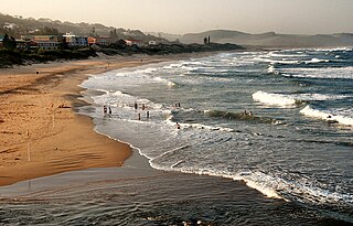
Umkomaas, officially renamed eMkhomazi, a small coastal village on the subtropical south coast of KwaZulu-Natal, South Africa was formed when a harbour was built in 1861 to export sugar. The village rests beside the mouth of the navigable uMkhomazi River, also known as the Mkhomazi or Umkomaas. With the successful dredging of Durban harbour's sandbar and arrival of the railway, like Port Shepstone, the harbour fell into disuse, but the village came to life.
Park Rynie is a small resort town on the South Coast of KwaZulu-Natal in South Africa. It was established in 1857 and possibly named after Renetta Hoets, wife of one of the John Phillip Hoffman, partner in the firm Nosworthy & Co. that bought the original farm for development. There was a whaling station here built during World War I, Park Rynie Whales Ltd. A breakwater, Rocky Bar Pier and a landing ramp were also built.
Umzinto is a town, located in the South Coast of KwaZulu-Natal, South Africa, approximately 67 kilometres south-west of Durban. It was a sugarcane growing area and the town was set up as the centre for a sugar mill.
Winklespruit is a small seaside resort on the South Coast of KwaZulu-Natal in South Africa and now forms part of the coastal town of Kingsburgh and the eThekwini Metropolitan Municipality, the Greater Durban metropolitan area.
Pinetown is a city that forms part of the eThekwini Metropolitan Municipality, based just inland from Durban in KwaZulu-Natal, South Africa. The town is situated 16 km north-west of Durban and 64 km south-east of Pietermaritzburg.
Westville is an area in KwaZulu-Natal, South Africa, and is just west and 10 km inland from the Durban CBD. It was a formerly independent municipality however it became part of the eThekwini Metropolitan Municipality in 2002.

Mount Edgecombe or Mt Edgecombe is a town in KwaZulu-Natal, South Africa, situated just north of Durban, which forms part of eThekwini, the Greater Durban Metropolitan area. Much of the suburb is cordoned off as a gated settlement comprising resorts, golf courses and a retirement home. It was previously a sugar growing area. The population increased by 89% between 2001 and 2011 from 3,874 to 7,323. Its name is derived from the Earl of Mount Edgecombe in Cornwall, United Kingdom.

oThongathi, previously and still commonly known as Tongaat, is a town in KwaZulu-Natal, South Africa, about 40 kilometres (25 mi) north of Durban and 28 kilometres (17 mi) south of KwaDukuza. It now forms part of eThekwini Metropolitan Municipality, or the Greater Durban area. The area is home to the oldest Indian community in South Africa, having been where the first indentured Indian laborers settled in 1860 to work in the sugar-cane plantations. Much of the architectural style in the town was the work of Ivan Mitford-Barberton, and many buildings are in the Cape Dutch style of architecture.

eMdloti, alternatively rendered Umdloti and also known as Umdloti Beach, is a small resort village situated along the KwaZulu-Natal North Coast, South Africa. It lies at the mouth of the Mdloti River approximately 24 km north-east of Durban and 11 km north-east of uMhlanga and now forms part of eThekwini, the Greater Durban Metropolitan Municipality.

Verulam is a town 24 kilometres north of Durban in KwaZulu-Natal, South Africa and forms part of the eThekwini Metropolitan Municipality, governing the Greater Durban metropolitan area.

Umlazi is a township in KwaZulu-Natal, South Africa, located south-west of Durban. Organisationally and administratively it forms part of the eThekwini Metropolitan Municipality and its South Municipal Planning Region.

The N2 is a national route in South Africa that runs from Cape Town through George, Gqeberha, East London, Mthatha, Port Shepstone and Durban to Ermelo. It is the main highway along the Indian Ocean coast of the country. Its current length of 2,255 kilometres (1,401 mi) makes it the longest numbered route in South Africa.
Umbogintwini is a suburb located approximately 23 km south-west of Durban, in the KwaZulu-Natal province of South Africa and it forms part of the eThekwini Metropolitan Municipality.
Magabeni is a small township in the KwaZulu-Natal province of South Africa.

KwaZulu-Natal South Coast is a region along the southern stretch of coastline of KwaZulu-Natal, South Africa, south of the coastal city of Durban.

Narend Singh is a South African politician who is the chief whip of the Inkatha Freedom Party in the National Assembly and the treasurer-general of the party. Prior to joining the National Assembly in 2007, he was a Member of the Executive Council in the KwaZulu-Natal provincial government from 1997 until 2006 and a member of the Senate from 1994 to 1996.
Ilfracombe is a coastal rural community on the South Coast of KwaZulu-Natal, South Africa and forms part of the eThekwini Metropolitan Municipality.

Amandawe also known as Amandawe Mission, or often informally abbreviated as A.M.A or A.M is a small township in the KwaZulu-Natal South Coast region of South Africa. The area is mostly populated with Black Africans.

