Umkomazi River

Last updated

uMkhomazi River
Umkomazi, Mkhomazi, Umkomaas
Umkomaas valley.jpg
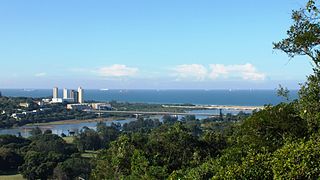
Umkomazi valley
South Africa relief location map.svg
Red pog.svg
Location of the Umkomazi River mouth
EtymologyMeaning 'the place of she-whales' in the Zulu language [1]
Location
Country South Africa
Region KwaZulu-Natal
Physical characteristics
SourceNear Thabana Ntlenyana
  location Drakensberg, Lesotho
  elevation3,000 m (9,800 ft)
Mouth Indian Ocean
  location
Umkomaas
  coordinates
30°12′1″S30°48′4″E / 30.20028°S 30.80111°E / -30.20028; 30.80111
  elevation
0 m (0 ft)

The uMkhomazi River is a river in KwaZulu-Natal, South Africa. [2]

Contents

Course

It rises in some of the highest eastwards-facing slopes of the Drakensberg mountains, near the mighty Thabana Ntlenyana. The river flows southeastwards towards the Indian Ocean, which it enters through a navigable estuary at Umkomaas (eMkhomazi), about 50 km southwest of Durban. [3] Its main tributaries are the Loteni, Nzinga, Mkomazane, Elands and the Xobho River. [4]

Towns on the uMkhomazi drainage basin include Bulwer, Impendle, Ixopo, Craigieburn and Boston. Presently the only dam in its catchment area is the Ixopo Dam, but other dams are planned. [5]

The uMkhomazi is part of the Mvoti to Umzimkulu Water Management Area. [6]

Ecology

The Mkhomazi State Forest and the Mkhomazi Wilderness Area are protected areas in the upper course of the Umkomazi River. [7]

The scaly yellowfish (Labeobarbus natalensis) is a fish found in the uMkhomazi River System as well as in the Umgeni, Umzimkulu, Tukhela and the Umfolozi. It is a common endemic species in KwaZulu-Natal Province and it lives in different habitats between the Drakensberg foothills and the coastal lowlands. [8]

Activities on the river

An annual two-day canoe (kayak) race is held on the river. "The Umko" is the second-oldest river marathon and the only one which neither starts nor finishes in a city or town. First held in 1966 the race was initially over three days. The overall distance has varied from 145 km down to the present length of 68 km. Famed as the roughest water race to be paddled in sprint boats which make negotiating the category 1 - 4 rapids tricky, it also had the longest daily sections when the distance was 130 km over two days. The race is held in a remote and rugged valley which makes access difficult and walking out a challenge if one should break a boat irreparably. Stories of paddlers spending a night in the valley before being able to walk out the next day have regularly made the national press and national radio. This premier wildwater race is organised by Kingfisher Canoe Club of Durban and attracts around 180 to 300 paddlers annually.

2016 saw the 50th running of the event and, remarkably, the 50th consecutive participation of the winner of the very first race, Charles Mason. Mason has completed 49 marathons, failing only in the 1970 event when he broke up 19 km into the 145 km race (one of the "four long years" in which the longest course was paddled from Hella Hella to the sea).

The race has had two starting points: Josephine's Bridge on the Richmond-Ixopo road, and Hella Hella bridge on the Richmond-Donnybrook road. The river between Hella Hella and the Number Eight rapid 20 km downstream has the steepest gradient (a fall of 7,6m per kilometre) and contains the toughest series of rapids. This section has been included in most, but not all, the races. The race has had many finishing points over the years depending mainly on weather, logistics and overland access.

The race has been run for 50 consecutive summers. In the 1971/1972 summer the race was moved to March 1972 resulting in no race in calendar 1971, but no summer has been missed. The current Umko champion Hank McGregor is also the current World Canoe Marathon champion, having won the 2016 world champs in Brandenburg, Germany.

History

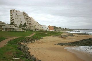
Surf near the uMkhomazi River mouth at Umkomaas, considered to be a safe swimming beach Umkomaas.jpg
Surf near the uMkhomazi River mouth at Umkomaas, considered to be a safe swimming beach

The first recorded trip down the river was in 1951 when Ian Player and Fred Schmidt paddled down from Josephine's bridge to the sea at Umkomaas village where the river flows into the Indian Ocean. Player was at the time famous for having won the first Dusi Canoe marathon earlier that year and later became famous in wildlife conservation, especially for having saved the white rhino from extinction. They took seven days to complete the 113 km distance and were supported by friendly inhabitants of the valley when they ran out of supplies. Various other trips were undertaken culminating in trips in 1965 and 1966 aimed specifically at the feasibility of holding a race, which necessitated scouting the river and roads along the banks for two accessible overnight campsites. Charles Mason was instrumental in that undertaking, succeeding in the scouting of the river and the access roads and in persuading the powers-that-be to sanction the new race on the South African canoeing calendar. He went on to win the first race with Tank Rogers, narrowly beating Paul Chalupsky and Jimmy Potgieter. [9]

Chalupsky went on to win the race seven times up to 1977. Other multiple winners include Tony Scott (six times to 1984); Robbie Herreveld (nine times to 2000); Deon Bruss (six times to 2008); Hank McGregor (seven times to 2016).

Staying overnight in a temporary camp in the remote valley was a compulsory part of the race for many years but in latter years this has changed with the overnight stop now being easily accessible at the Hella Hella bridge (now the start of the second day in a reverse-order format since 2009 which has greatly simplified the challenging logistics of the race and hopefully ensured its survival).

See also

Related Research Articles

<span class="mw-page-title-main">KwaZulu-Natal</span> Province in South Africa

KwaZulu-Natal is a province of South Africa that was created in 1994 when the government merged the Zulu bantustan of KwaZulu and Natal Province.

<span class="mw-page-title-main">Tugela River</span> River in South Africa

The Tugela River is the largest river in KwaZulu-Natal Province, South Africa. With a total length of 560 km (350 mi), and a drop of 1370 metres in the lower 480 km, it is one of the most important rivers of the country.

<span class="mw-page-title-main">Umkomaas</span> Small coastal village in KwaZulu-Natal, South Africa

Umkomaas, also known by its official name eMkhomazi, is a small coastal village on the subtropical South Coast of KwaZulu-Natal, South Africa was formed when a harbour was built in 1861 to export sugar. The village rests beside the mouth of the navigable uMkhomazi River, also known as the Mkhomazi or Umkomaas. With the successful dredging of Durban harbour's sandbar and arrival of the railway, like Port Shepstone, the harbour fell into disuse, but the village came to life. It is administered as eMkhomazi Area, together with the nearby areas of Craigieburn, Clansthal, Crowder, Amahlongwa and Hull Valley as part Ward 99 in the eThekwini Metropolitan Municipality

Harrismith is a large town in the Free State province of South Africa. It was named for Sir Harry Smith, a 19th-century British governor and high commissioner of the Cape Colony. It is situated by the Wilge River, alongside the N3 highway, about midway between Johannesburg, about 275 km to the north-west, and Durban to the southeast. The town is located at the junction of the N5 highway, which continues westward towards the provincial capital Bloemfontein, some 340 km to the south-west. This important crossroads in South Africa's land trade routes is surrounded by mesas and buttes. It is located at the base of one of these called Platberg.
<span class="mw-page-title-main">Umgeni River</span> River in South Africa

The Umgeni River or Mgeni River is a river in KwaZulu-Natal, South Africa. It rises in the "Dargle" in the KZN Midlands, and its mouth is at Durban, some distance north of Durban's natural harbour. It is generally agreed its name means "the river of entrance" in Zulu, though other meanings have been suggested.

<span class="mw-page-title-main">Msunduzi River</span> River in South Africa

The Msunduzi River is a river in KwaZulu-Natal, South Africa. It is also known by its anglicised name, the Dusi River. The original name, Msunduzi, is isiZulu.

<span class="mw-page-title-main">R56 (South Africa)</span> Road in South Africa

The R56 is a provincial route in South Africa that connects Middelburg with Pietermaritzburg via Molteno, Maclear and Kokstad. It is co-signed with the N2 between Kokstad and Stafford's Post for 39 kilometres.

<span class="mw-page-title-main">Umzimkulu River</span> River in South Africa

The Mzimkulu River is a river in South Africa. In the past, the Mzimkulu formed part of the border between Eastern Cape and KwaZulu-Natal provinces. Presently this river is part of the Mvoti to Umzimkulu Water Management Area. In late February of every year, the river is host to one of South Africa's most popular canoe races, the Drak Challenge.

<span class="mw-page-title-main">Dusi Canoe Marathon</span>

The Dusi Canoe Marathon is a marathon canoe race held over three days between Pietermaritzburg and Durban, South Africa. It is run along the Msunduzi and Mgeni Rivers over a total distance of 120 kilometres (75 mi). The race attracts between 1600 and 2000 paddlers each year, making it the biggest canoeing event on the African continent. It is organised by the Natal Canoe Club. The clubhouse is located on the banks of the Msunduzi River, at the exact start point of the race.

<span class="mw-page-title-main">Ohlanga River</span> River in South Africa

The Ohlanga River is a river in KwaZulu-Natal, South Africa, which empties into the Indian Ocean just north of uMhlanga, north of Durban. The river has extensive reed beds in the estuary at its mouth, which is only 7 km southwest from the mouth of the Mdloti River. Presently, this river is part of the Mvoti to Umzimkulu Water Management Area.

<span class="mw-page-title-main">Vulamehlo Local Municipality</span> Local municipality in KwaZulu-Natal, South Africa

Vulamehlo Local Municipality was a local municipality in Ugu District Municipality, KwaZulu-Natal. It was located south of the eThekwini municipality and bordered by uMdoni to the east, Mkhambathini and Richmond to the north and Ubuhlebezwe to the west. There is an almost equal split of land between commercial agriculture and traditional settlement areas. 48% of the area is held under communal ownership through traditional authorities; the balance of the area is privately owned, except for Vernon Crookes Nature Reserve, which is managed by Ezemvelo KZN Wildlife. In 2016 the municipality was divided between eThekwini and uMdoni.

uKhahlamba-Drakensberg Park Part of a world heritage site in KwaZulu-Natal, South Africa

The uKhahlamba-Drakensberg Park is a protected area in the KwaZulu-Natal province of South Africa, covering 2,428.13 km2 (938 sq mi), and is part of the Maloti-Drakensberg Park, a World Heritage Site. The park includes Royal Natal National Park, a provincial park, and covers part of the Drakensberg, an escarpment formation with the highest elevations in southern Africa.

Impendle is a town in Umgungundlovu District Municipality in the KwaZulu-Natal province of South Africa.

St Faith’s is a village in the Umzumbe Local Municipality in the KwaZulu-Natal province of South Africa.

Magabeni is a small township in the KwaZulu-Natal province of South Africa.

The Mvoti River or uMvoti River is a river in the KwaZulu-Natal region of South Africa. The Mvoti River, in the vicinity of KwaDukuza, is subjected to extensive water abstraction, which is then utilised for irrigation, industrial use, urban water requirements and various domestic uses by informal settlements.

<span class="mw-page-title-main">South Coast (KwaZulu-Natal)</span> Coastal region in KwaZulu-Natal, South Africa

KwaZulu-Natal South Coast is a region along the southern stretch of coastline of KwaZulu-Natal, South Africa, south of the coastal city of Durban.

Ilfracombe is a coastal rural community on the South Coast of KwaZulu-Natal, South Africa and forms part of the eThekwini Metropolitan Municipality.
<span class="mw-page-title-main">North Coast (KwaZulu-Natal)</span> Coastal region in KwaZulu-Natal, South Africa

The KwaZulu-Natal North Coast, better known as the North Coast is a coastal region north of Durban in KwaZulu-Natal, South Africa. It stretches from Zinkwazi Beach in the north to Zimbali near Ballito in the south. The coastal region is governed by the KwaDukuza Local Municipality, forming part of the iLembe District Municipality.

References

  1. Dictionary of Southern African Place Names
  2. Meintjes, Malcolm (2005). Remarkable Flyfishing Destinations of Southern Africa. Struik. ISBN   1868729761.
  3. Mkomazi Region
  4. Mvoti to Umzimkulu WMA 11
  5. Mkomazi Region
  6. Is there a role for traditional governance systems in South Africa's new water management regime?
  7. Mkhomazi Wilderness Area
  8. "Technical Report on the State of Yellowfishes in South Africa 2007" (PDF). Archived from the original (PDF) on 29 June 2017. Retrieved 7 April 2012.
  9. Mooney, James (5 July 2017), "The Colonial and Revolutionary Period—1654–1784", Historical Sketch of the Cherokee, Routledge, pp. 19–50, doi:10.4324/9780203790038-3, ISBN   978-0-203-79003-8 , retrieved 30 May 2020

Books

Regularly featured in mainstream Natal newspapers, The Mercury and The Daily News (www.iol.co.za), Durban and The Witness (http://thewitness.newspaperdirect.com/epaper/viewer.aspx), Pietermaritzburg

http://www.kingfishercc.co.za/

http://www.canoesa.org.za