In the United Kingdom, a scheduled monument is a nationally important archaeological site or historic building, given protection against unauthorised change.
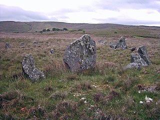
Corick is a megalithic site and townland in the civil parish of Ballynascreen, County Londonderry, Northern Ireland. It includes a stone circle and a stone row. The Corick stone circles and alignments are located 2 km north east of Ballybriest court-tomb, 400 metres south of Corick clachan, near a stream. There are some 5 circles and 3 stone-rows. The stone alignments and circle are Scheduled Historic Monuments in Corick at grid reference: Area of H780 896.
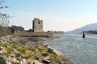
Narrow Water Castle is a famous 16th-century tower house and bawn near Warrenpoint in Northern Ireland. It is beside the A2 road and on the County Down bank of the Clanrye River, which enters Carlingford Lough a mile to the south. Narrow Water Castle was given into state care in 1956. It is a state care historic monument in the townland of Narrow Water, in Newry and Mourne District Council district, at grid ref: J1256 1939.

Gosford Castle is a 19th-century country house situated in Gosford, a townland of Markethill, County Armagh, Northern Ireland. It was built for The 2nd Earl of Gosford, and designed in the Norman revival style by London architect Thomas Hopper. It is a Grade A listed building, and is said to be Ulster's largest. The Earls of Gosford occupied the castle until 1921, and the estate was later purchased by the Ministry of Agriculture to form Gosford Forest Park. The building subsequently deteriorated and in 2006 was sold to a development company who converted the castle into private dwellings.

Moyry Castle is situated in County Armagh, Northern Ireland. It was built during the latter stages of the Nine Years' War in June 1601 by Lord Mountjoy to help secure Moyry Pass and the Gap of the North. It is set in the corner of a small bawn and is a small rectangular tower three storeys high.
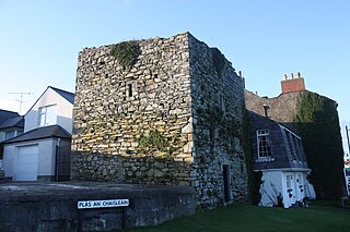
Margaret's Castle is a castle in Ardglass, County Down, Northern Ireland. It is a small Tower house probably built in the 15th century. Only two storeys still exist but there is evidence that it was at least three storeys high. It is vaulted above the ground floor with a rectangular tower with projecting turrets in the north west wall. The doorway between the turrets was protected by a murder-hole. A spiral stairway rises within the west turret.
Bright Castle is a castle near Downpatrick, County Down, Northern Ireland. It is a three-storey Tower house which was probably built in the late 15th century or early 16th century. Less than half of the original structure survives. The east wall, about 6m long externally, and adjoining fragments of the north and south walls stand to roof level but the western portion of the castle has completely disappeared. There are some indications that there may have been a vault above the ground floor.

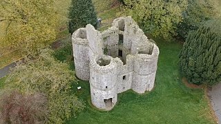
Greencastle is a castle in County Down, Northern Ireland. It is a royal castle built in the 13th century. While it dates mainly from the 13th century, it had substantial 15th- and 16th-century alterations. The large rectangular keep with three vaulted chambers at the ground floor is approached across a rock-cut ditch. It was originally surrounded by outer rectangular walls with four corner towers. It is likely to have been built by Hugh de Lacy, along with Carlingford Castle on the opposite side of Carlingford Lough, to guard the narrow entry channel to the Lough, and the ferry crossing between the two.
Meigh is a small village and townland near Slieve Gullion in County Armagh, Northern Ireland. It had a population of 444 people in the 2001 Census. It lies within the Newry and Mourne District Council area.

Benburb Castle is a castle situated in Benburb, County Tyrone, Northern Ireland. It is a plantation bawn built in 1611 by Sir Richard Wingfield, on the site of an O'Neill strong point on a bend in the Blackwater River thought to have been constructed as early as the 15th century. It is an irregular four-sided bawn with the entrance in the north wall. There are large rectangular flanking towers at the north-east and north-west corners and a smaller round tower at the south-east corner It is built on a limestone cliff overlooking the River Blackwater, the border between County Tyrone and County Armagh. A 19th-century tower house occupies the south west area of the bawn. The castle is in excellent condition having been recently restored and stands in the grounds of the imposing Servite Priory, a religious order based in the village.

Mountjoy Castle is situated near the village of Brockagh, in Magheralamfield townland in County Tyrone, Northern Ireland, on a hill overlooking Lough Neagh. It was built by Lord Mountjoy in 1602 and partly burned in 1643 by Captain Turlough Gruama O'Quin. It is a two-storey brick building and the lower storey is stone-faced on the outside. It consists of a central rectangular block with four spear-shaped angle towers with gun loops. The north west tower is partly demolished and the west curtain wall destroyed. The entrance was on the south side of the east curtain wall. On the first floor there are some wide windows.
Roughan Castle is located about 1 mile (1.6 km) outside Newmills in the south-east of County Tyrone in Northern Ireland, on the Dungannon to Stewartstown road. It was built around 1618 by Andrew Stewart (1590-1639), who was later, in 1628, created a baronet and who, later still, succeeded as The 2nd Baron Castle Stuart, in 1629. He was the eldest son of The 1st Baron Castle Stuart (formerly The 3rd Lord Ochiltree; 1560-1629). Both the 1st and 2nd Barons Castle Stuart had come from Scotland during the Plantation of Ulster and established the nearby town of Stewartstown. Andrew Stewart acquired the land of Ballokevan from Robert Stewart between 1610 and 1619 and built his castle overlooking Roughan Lough. It is a small square castle, three storeys high with a central tower 20 feet (6.1 m) square, flanked by thick rounded towers at each corner.

Lislea is a small village and townland near Slieve Gullion in County Armagh, Northern Ireland. It is within the civil parish of Killevy and the historic barony of Orior Upper. Today it is within the Newry, Mourne and Down District Council area. It borders the townlands of Ballard, Carricnagalliagh, Aghmakane, Duburren and Drumilly. In the 2001 Census it had a population of 84 people.

White Island is an island in Lower Lough Erne, County Fermanagh, Northern Ireland. It is situated in Castle Archdale Bay off the east shore of Lower Lough Erne. The ruins of an ancient church are found near the shore, built on the site of an earlier monastic settlement. It still has an intact arched Romanesque doorway. The Church and carved figures are State Care Historic Monuments sited in the townland of White Island, in Fermanagh and Omagh District Council area, at grid ref: H1753 6000. The rath, earthwork, and area surrounding the state care monument are Scheduled Historic Monuments, at grid ref: H1753 6000. The island is accessed by ferry from the marina in Castle Archdale Country Park, near Irvinestown. Location: Open Street Map Reference

Brackaville or Bracaville is a village and townland near Coalisland in County Tyrone, Northern Ireland. It is situated in the historic barony of Dungannon Middle and the civil parish of Donaghenry and covers an area of 235 acres on the western side of Lough Neagh.

Loughbrickland Crannóg is a Bronze Age man-made island known as a crannóg, four miles (6.5 km) south west of Banbridge, County Down, Northern Ireland. It is situated in the middle of the lough, 1 mile from the village of Loughbrickland. The crannóg in Loughbrickland is a Scheduled Historic Monument in the townland of Drumnahare, in Banbridge District, at grid reference J1113 4118. It is easily visible from the south-bound carriageway of the trunk A1 Belfast-Dublin route, just past the B3 Rathfriland exit.
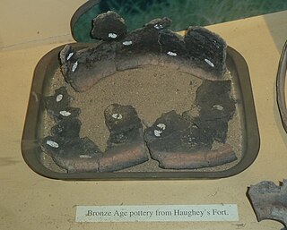
Haughey's Fort is a hill fort in County Armagh, Northern Ireland, 2 1⁄4 miles (3.6 km) west of the city of Armagh. It is named after the farmer who owned the land it is situated on in the later 19th century. The large hilltop enclosure that is Haughey's Fort is a Scheduled Historic Monument in the townland of Tray, in Armagh City and District Council area, at grid ref: H8351 4529.
Dorsey or Dorsy is a small village and townland between Belleeks and Cullyhanna in County Armagh, Northern Ireland. It has an estimated population of 130-160 people and includes about 30-35 houses.

Ringhaddy is a townland on the shores of Strangford Lough, County Down, Northern Ireland, 5 km south of Whiterock. It is in the civil parish of Killinchy and the historic barony of Dufferin.

Poyntzpass is a small village on the border between southern County Armagh and County Down in Northern Ireland. It is situated in the civil parish of Ballymore and the historic barony of Orior Lower within the Armagh City and District Council area. It had a population of 614 people in the 2011 Census. It was a part of the South Armagh constituency and is now part of the Newry and Armagh constituency, and was one of the places in South Armagh where the Ulster Covenant could be signed.