
Montgomery County is located in the State of Alabama. As of the 2020 census, its population was 228,954, making it the fifth-most populous county in Alabama. Its county seat is Montgomery, the state capital. Montgomery County is included in the Montgomery, AL Metropolitan Statistical Area.
The Southeastern League was the name of four separate baseball leagues in minor league baseball which operated in the Southeastern and South Central United States in numerous seasons between 1897 and 2003. Two of these leagues were associated with organized baseball; the third and most recent incarnation was an independent league that operated for two seasons in 2002–03.

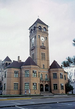
Lee County is a county located in east central Alabama. As of the 2020 census the population was 174,241. The county seat is Opelika, and the largest city is Auburn. The county was established in 1866 and is named for General Robert E. Lee (1807–1870), who served as General in Chief of the Armies of the Confederate States in 1865. Lee County comprises the Auburn-Opelika, AL Metropolitan Statistical Area, which is included in the Columbus-Auburn-Opelika, GA-AL Combined Statistical Area.
Macon County is a county located in the east central part of the U.S. state of Alabama. As of the 2020 census, the population was 19,532. Its county seat is Tuskegee. Its name is in honor of Nathaniel Macon, a member of the United States Senate from North Carolina.

Eufaula is the largest city in Barbour County, Alabama, United States. As of the 2010 census the city's population was 13,137.

Aliceville is a city in Pickens County, Alabama, United States, located thirty-six miles west of Tuscaloosa. At the 2010 census its population was 2,486, down from 2,567 in 2000. Founded in the first decade of the 20th century and incorporated in 1907, the city has become notable for its World War II-era prisoner-of-war camp, Camp Aliceville. Since 1930, it has been the largest municipality in Pickens County.

Macon, officially Macon–Bibb County, is a consolidated city-county in Georgia, United States. Situated near the fall line of the Ocmulgee River, it is 85 miles (137 km) southeast of Atlanta and near the state's geographic center — hence its nickname "The Heart of Georgia."

Sidney Clopton Lanier was an American musician, poet and author. He served in the Confederate States Army as a private, worked on a blockade-running ship for which he was imprisoned, taught, worked at a hotel where he gave musical performances, was a church organist, and worked as a lawyer. As a poet he sometimes used dialects. Many of his poems are written in heightened, but often archaic, American English. He became a flautist and sold poems to publications. He eventually became a professor of literature at the Johns Hopkins University in Baltimore, and is known for his adaptation of musical meter to poetry. Many schools, other structures and two lakes are named for him, and he became hailed in the South as the "poet of the Confederacy". A 1972 US postage stamp honored him as an "American poet".

U.S. Route 80 or U.S. Highway 80 (US 80) is a major east–west United States Numbered Highway in the Southern United States, much of which was once part of the early auto trail known as the Dixie Overland Highway. As the "0" in the route number indicates, it was originally a cross-country route, from the Pacific Ocean to the Atlantic Ocean. Its original western terminus was at Historic US 101 in San Diego, California. However, the entire segment west of Dallas, Texas, has been decommissioned in favor of various Interstate Highways and state highways. Currently, the highway's western terminus is at an interchange with Interstate 30 (I-30) on the Dallas–Mesquite, Texas city line. Its eastern terminus is in Tybee Island, Georgia near the Atlantic Ocean. Between Jonesville, Texas and Kewanee, Mississippi, US 80 runs parallel to or concurrently with Interstate 20. It also currently runs through Dallas, Texas; Shreveport, Louisiana; Jackson, Mississippi; Montgomery, Alabama; Columbus, Georgia; Macon, Georgia; and Savannah, Georgia.

The Tallapoosa River runs 265 miles (426 km) from the southern end of the Appalachian Mountains in Georgia, United States, southward and westward into the Appalachian foothills in Alabama. It is formed by the confluence of McClendon Creek and Mud Creek in Paulding County, Georgia. Lake Martin at Dadeville, Alabama is a large and popular water recreation area formed by a dam on the river. The Tallapoosa joins the Coosa River about 10 miles (16 km) northeast of Montgomery near Wetumpka to form the Alabama River.

The Wiregrass region, also known as the Wiregrass plains or Wiregrass country, is an area of the Southern United States encompassing parts of southern Georgia, southeastern Alabama, and the Florida Panhandle. The region is named for the native Aristida stricta, commonly known as wiregrass due to its texture.

The Central of Georgia Railway started as the Central Rail Road and Canal Company in 1833. As a way to better attract investment capital, the railroad changed its name to Central Rail Road and Banking Company of Georgia. This railroad was constructed to join the Macon and Western Railroad at Macon, Georgia, in the United States, and run to Savannah. This created a rail link from Chattanooga, on the Tennessee River, to seaports on the Atlantic Ocean. It took from 1837 to 1843 to build the railroad from Savannah to the eastern bank of the Ocmulgee River at Macon; a bridge into the city was not built until 1851.
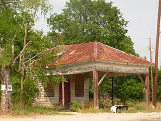
Marvyn, also spelled Marvin, is an unincorporated community located in southern Lee County, Alabama, United States. It sits at the crossroads of Alabama Highway 51 and U.S. Highway 80, and in the Lee County "panhandle" between Russell County and Macon County. It is part of the Columbus, Georgia-Alabama Metropolitan Area.

Fred David Gray is an American civil rights attorney, preacher, activist, and state legislator from Alabama. He handled many prominent civil rights cases, such as Browder v. Gayle, and was elected to the Alabama House of Representatives in 1970, along with Thomas Reed, both from Tuskegee. They were the first black state legislators in Alabama in the 20th century. He served as the president of the National Bar Association in 1985, and in 2001 was elected as the first African-American President of the Alabama State Bar.

George Washington Bonaparte Towns was a United States lawyer, legislator, and politician. He served in the United States House of Representatives on three occasions and was the 39th Governor of Georgia from 1847 to 1851.
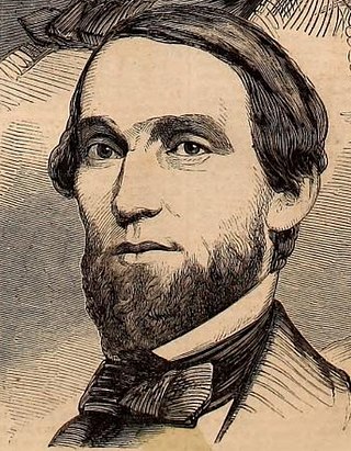
David Clopton was a prominent Alabama politician.
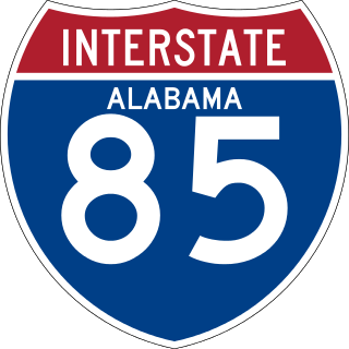
Interstate 85 (I-85) is a part of the Interstate Highway System that runs from Montgomery, Alabama, to Petersburg, Virginia. In Alabama, the Interstate Highway runs 80 miles (130 km) from I-65 in Montgomery northeast to the Georgia state line near Valley. Although it is nominally north–south as it carries an odd number, I-85 travels east–west through the state. It is the primary highway between Montgomery and Atlanta. The Interstate also connects Montgomery with Tuskegee, Auburn, Opelika, and, indirectly, Phenix City and Columbus, Georgia.
U.S. Route 80 (US 80) is a 296-mile-long (476 km) U.S. Highway in the U.S. state of Georgia. It travels west-to-east from the Alabama state line in Columbus across the central portion of the state through cities such as Macon, Dublin, Statesboro, and Savannah to connect to its eastern terminus at an intersection with Tybrisa Street and Inlet Avenue in Tybee Island, near the Atlantic Ocean. Here, the roadway continues as Butler Avenue. US-80 is the main east-west non-Interstate route through Georgia.
Cecil is an unincorporated community in Montgomery County, Alabama, United States. Cecil is located on Alabama State Route 110, 17.6 miles (28.3 km) east-southeast of Montgomery. Cecil had a post office until it closed on May 20, 1986; it still has its own ZIP code, 36013.
For the Methodist institution in Birmingham, Alabama of the same name that existed 1866-1923 see Sherman Industrial Institute


