Danby, New York

Last updated

Danby, New York
USA New York location map.svg
Red pog.svg
Danby, New York
Location within the state of New York
Coordinates: 42°20′15″N76°28′22″W / 42.33750°N 76.47278°W / 42.33750; -76.47278
Country United States
State New York
County Tompkins
Area
[1]
  Total53.77 sq mi (139.28 km2)
  Land53.55 sq mi (138.70 km2)
  Water0.22 sq mi (0.58 km2)
Elevation
1,532 ft (467 m)
Population
 (2020) [2]
  Total3,457 Increase2.svg
  Estimate 
(2021) [2]
3,423
  Density66.01/sq mi (25.49/km2)
Time zone UTC-5 (Eastern (EST))
  Summer (DST) UTC-4 (EDT)
FIPS code 36-19620
GNIS feature ID0978882

Danby is a town in Tompkins County, New York, United States. The population was 3,457 at the 2020 census. [2] The town is in the southern part of the county and is south of the city of Ithaca.

Contents

History

The Cayuga people, one of the Six Nations of the Haudenosaunee, occupied the land at the head of Cayuga Lake for centuries. Indigenous peoples were largely forced out of Upstate New York by the Sullivan-Clinton Expedition in 1779. The land that would become the Town of Danby was a part of the Watkins and Flint Purchase, a 336,380 acre patent granted by New York State to numerous eastern investors in 1794. Danby's first European-American settlers, including Isaac and John Dumond and Jacob and Joseph Yaple, arrived in 1795.

The town of Danby was created from the town of Spencer on February 22, 1811. Danby was part of Tioga County until 1822 when it was annexed by Tompkins County. In 1839, a part of the town of Caroline was added to Danby, and part of Danby was lost to the town of Dryden in 1856.

The Ithaca-Owego Turnpike was completed through Danby in 1811, connecting Cayuga Lake with the Susquehanna River. Today, Route 96B generally follows the same route and continues to provide an important connection between Ithaca and Binghamton and communities downstate.

Notable people

Geography

Tompkins County is often included in the Finger Lakes Region of New York State, but is sometimes included in the Southern Tier Region. The physical geography of Danby mirrors this duality as the drainage divide between the Susquehanna River and Lake Ontario runs across the town. Generally, waters in the northern and western portions of the town flow north into Cayuga Lake, Lake Ontario, and the St. Lawrence River, while waters in the southeastern portion of the town flow south into the Susquehanna River and Chesapeake Bay.

Danby is situated along the northern edge of the Allegheny Plateau, part of the Appalachian Mountains. The town is characterized by three primary land forms:

Elevations range from approximately 450 feet above sea level where Cayuga Inlet crosses the northern town line, to about 1230 feet at Town Hall in Danby Hamlet, to just over 1800 feet at Dawes Hill in the southwestern part of the town and Roundtop in the southeastern part of the town. The dramatic hill and valley lands of Danby have sometimes been referred to as the 'Danby Highlands'.

According to the United States Census Bureau, the town has a total area of 53.8 square miles (139 km2), of which 53.6 square miles (139 km2) is land and 0.2 square miles (0.52 km2) (0.33%) is water.

Demographics

Historical population
CensusPop.Note
1820 2,001
1830 2,48124.0%
1840 2,5703.6%
1850 2,411−6.2%
1860 2,261−6.2%
1870 2,126−6.0%
1880 2,035−4.3%
1890 1,707−16.1%
1900 1,449−15.1%
1910 1,235−14.8%
1920 1,143−7.4%
1930 1,40723.1%
1940 1,253−10.9%
1950 1,55524.1%
1960 2,05932.4%
1970 2,1414.0%
1980 2,44914.4%
1990 2,85816.7%
2000 3,0075.2%
2010 3,32910.7%
2020 3,4573.8%
2021 (est.)3,423 [2] −1.0%
U.S. Decennial Census [4]

As of the census [5] of 2010, there were 3,007 people, 1,187 households, and 830 families residing in the town. There were 1,264 housing units at an average density of 23.6 per square mile (9.1/km2). The racial makeup of the town as 93.65% White, 2.69% African American, 0.17% Native American, 1.06% Asian, 0.43% from other races, and 2.00% from two or more races. Hispanic or Latino of any race were 1.70% of the population.

There were 1,187 households, out of which 33.8% had children under the age of 18 living with them, 56.6% were married couples living together, 8.7% had a female householder with no husband present, and 30.0% were non-families. 21.2% of all households were made up of individuals, and 5.0% had someone living alone who was 65 years of age or older. The average household size was 2.53 and the average family size was 2.94.

In the town, the population was spread out, with 24.5% under the age of 18, 6.7% from 18 to 24, 30.0% from 25 to 44, 28.9% from 45 to 64, and 9.9% who were 65 years of age or older. The median age was 40 years. For every 100 females, there were 103.5 males. For every 100 females age 18 and over, there were 98.2 males.

The median income for a household in the town was $50,348, and the median income for a family was $52,303. Males had a median income of $34,181 versus $30,136 for females. The per capita income for the town was $23,078. About 3.9% of families and 5.1% of the population were below the poverty line, including 5.0% of those under age 18 and 2.8% of those age 65 or over.

Communities and locations in Danby

Transportation

New York State Route 96B (Danby Road) runs north-south through the central portion of the town, generally along the route of the 1811 Ithaca-Owego Turnpike.

New York State Routes 34/96 runs north-south through the western portion of the town, through the valley of the Cayuga Inlet.

A Norfolk Southern Railway branch line between Sayre, PA and Ludlowville, NY runs through the western portion of the town, through the valley of the Cayuga Inlet. This railroad was built in 1871 as the Ithaca & Athens Railroad and later become part of the Lehigh Valley Railroad. There was a depot in West Danby, on the north side of Station Road, east of the tracks. Passenger service to West Danby ended in the 1940s and passenger service on this line ended in 1961.

A former branch line of the Delaware, Lackawanna, and Western Railroad ran across the far northeastern part of the town, along the border with the Town of Caroline. This was originally built in 1834 as the Ithaca and Owego Railroad, one of the first in the United States. The line originally included two inclined planes to descend into Ithaca. These were rebuilt as a switchback railroad and leased to the DL&W in 1855. The line was abandoned in 1956.

The Finger Lakes Trail crosses the town east-west through the Danby State Forest.

Related Research Articles

<span class="mw-page-title-main">Ithaca, New York</span> City in New York, United States

Ithaca is a city in and the county seat of Tompkins County, New York, United States. Situated on the southern shore of Cayuga Lake in the Finger Lakes region of New York, Ithaca is the largest community in the Ithaca metropolitan statistical area. It is named after the Greek island of Ithaca. As of 2020, the city's population was 32,108.

<span class="mw-page-title-main">Tompkins County, New York</span> County in New York, United States

Tompkins County is a county located in the U.S. state of New York. As of the 2020 census, the population was 105,740. The county seat is Ithaca. The name is in honor of Daniel D. Tompkins, who served as Governor of New York and Vice President of the United States. The county is part of the Southern Tier region of the state.

<span class="mw-page-title-main">Harford, New York</span> Town in New York, United States

Harford is a town in Cortland County, New York, United States. The population was 943 at the 2010 census. Harford is in the southwestern corner of Cortland County and is south of Cortland.

<span class="mw-page-title-main">Virgil, New York</span> Town in New York, United States

Virgil is a town in Cortland County, New York, United States. The population was 2,401 at the 2010 census. The name is from the Roman poet Virgil. The town is in the southwestern part of Cortland County and is south of the city of Cortland.

<span class="mw-page-title-main">Ulysses, New York</span> Town in New York, United States

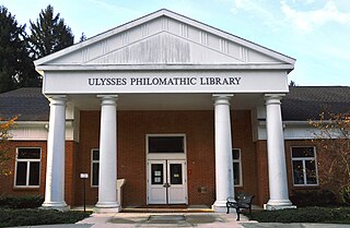
Ulysses is a town located in northwest Tompkins County, New York, U.S. The population was 4,940 at the 2020 census. The town was named after the hero of the Odyssey.

Candor is a town in Tioga County, New York, United States. The population was 5,172 at the 2020 census.

<span class="mw-page-title-main">Owego, New York</span> Town in Tioga County, New York, US

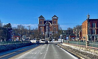
Owego is a town in Tioga County, New York, United States. The population was 18,728 at the 2020 census. The name is derived from the Iroquois word Ahwaga, meaning "where the valley widens".

Spencer is a town in Tioga County, New York, United States. The population was 2,976 at the 2020 census. The town and its primary village are named after Ambrose Spencer. It lies on the western border of the county and is south of Ithaca. Inside the town is the Village of Spencer. The village of Candor borders the town to the east and southeast, with Waverly to the southwest and Van Etten to the west, while Danby is to the north.

<span class="mw-page-title-main">New York State Route 13</span> State highway in New York, US

New York State Route 13 (NY 13) is a state highway that runs mainly north–south for 152.30 miles (245.10 km) between NY 14 in Horseheads and NY 3 west of Pulaski in Central New York in the United States. In between, NY 13 intersects with Interstate 81 (I-81) in Cortland and Pulaski and meets the New York State Thruway (I-90) in Canastota. NY 13 is co-signed with several routes along its routing, most notably NY 34 and NY 96 between Newfield and Ithaca; NY 80 between DeRuyter and Cazenovia; and NY 5 between Chittenango and Canastota.

This is a list of trails in Ithaca, New York.

<span class="mw-page-title-main">New York State Route 96</span> State highway near Finger Lakes, New York, US

New York State Route 96 (NY 96) is a 126.01-mile-long (202.79 km) northwest–southeast state highway in the Finger Lakes region of New York in the United States. The southern terminus of the route is at an interchange with NY 17 in the Southern Tier village of Owego, Tioga County. Its northern terminus is at a junction with East Main Street in the city of Rochester, Monroe County. Between the two endpoints, NY 96 passes through the city of Ithaca and the villages of Waterloo, Victor, and Pittsford. NY 96 is signed north–south for its entire length, although most of the route in Ontario County travels in an east–west direction.

<span class="mw-page-title-main">New York State Route 38</span> Highway in New York

New York State Route 38 (NY 38) is a north–south state highway in the Finger Lakes region of New York in the United States. Its southern terminus is at an intersection with NY 96 in the town of Owego in Tioga County. The northern terminus is at a junction with NY 104A in the town of Sterling in Cayuga County. NY 38 is a two-lane local road for most of its length. The route is the main access road to parts of Auburn, Dryden, Newark Valley and Port Byron. It passes through mountainous terrain in Tioga and Cortland counties, but the terrain levels out as it heads through the Finger Lakes area and Cayuga County.

<span class="mw-page-title-main">New York State Route 79</span> State highway in New York, US

New York State Route 79 (NY 79) is a 93.18-mile-long (149.96 km) east–west state highway in the Southern Tier of New York, in the United States. The western terminus of the route is at the intersection with NY 414 near the southern end of Seneca Lake just northeast of Watkins Glen. Its eastern terminus is at the Pennsylvania state line in the town of Windsor in Broome County, where it connects to Pennsylvania Route 92 (PA 92). NY 79 passes through three regions; it starts in the Finger Lakes region, runs through Central New York and ends on the western fringes of the Catskills. The route is signed east–west, but from Whitney Point to the state line it runs in a north–south orientation and is signed north–south a few miles south of Center Village, a hamlet that is a few miles south of Harpursville.

<span class="mw-page-title-main">New York State Route 89</span> State highway in central New York, US

New York State Route 89 (NY 89) is a north–south state highway in central New York in the United States. It extends for 62.35 miles (100.34 km) from an intersection with NY 13, NY 34, and NY 96 in the Tompkins County city of Ithaca to an interchange with NY 104 in the Wayne County town of Wolcott. The route spans a total of three counties, connecting the heart of the Finger Lakes Region to a point 6 miles (10 km) south of Lake Ontario. Along the way, NY 89 intersects two regionally important highways: the conjoined routes of U.S. Route 20 (US 20) and NY 5 in Seneca Falls and NY 31 in Savannah. NY 89 runs along the western edge of Cayuga Lake from Ithaca to Seneca Falls.

<span class="mw-page-title-main">New York State Route 96B</span> State highway in New York, US

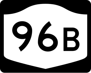
New York State Route 96B (NY 96B) is a north–south state highway in the Southern Tier of New York in the United States. It connects NY 96 in the village of Candor in Tioga County to NY 13, NY 34, and NY 96 in the city of Ithaca in Tompkins County. NY 96B approaches Ithaca from the south as Danby Road and then as South Aurora Street, before turning westward onto Clinton Street and proceeding to its northern terminus at a junction with NY 13, NY 34, and NY 96. The portion of NY 96B from the Ithaca city line to its northern terminus is maintained by the city.

<span class="mw-page-title-main">Ithaca (town), New York</span> Town in New York, United States

Ithaca is a town in Tompkins County, New York, United States. The town's population was 22,283 at the 2020 census. The town is in the central part of the county, in the Finger Lakes–Southern Tier region of New York, and is part of the Ithaca Metropolitan Statistical Area. The Town of Ithaca is a horseshoe-shaped portion of the metropolitan area of Ithaca, New York, surrounding the City of Ithaca and being the city's only border. Ithaca College is located in the South Hill section of the town.

Lansing is a town in Tompkins County, New York, United States. The population was 11,565 at the 2020 census.

<span class="mw-page-title-main">Cayuga and Susquehanna Railroad</span> Railroad in New York, United States

The Cayuga and Susquehanna Railroad was a railroad in the state of New York, in the United States. Its line ran from Ithaca, New York, to Owego, New York. It was founded in 1829 and began operations in 1834. The Delaware, Lackawanna and Western Railroad (Lackawanna) leased the company in 1855, but it remained in existence as a non-operating subsidiary. It was conveyed to Conrail in the bankruptcy of the Erie Lackawanna Railway, successor to the Lackawanna, in 1976.

West Danby is a hamlet and census-designated place (CDP) in the town of Danby, Tompkins County, New York, United States. It was first listed as a CDP prior to the 2020 census.

Danby is the primary hamlet and a census-designated place (CDP) in the town of Danby, Tompkins County, New York, United States. It was first listed as a CDP prior to the 2020 census.

References

  1. "2016 U.S. Gazetteer Files". United States Census Bureau. Retrieved July 5, 2017.
  2. 1 2 3 4 Bureau, US Census. "City and Town Population Totals: 2020—2021". Census.gov. US Census Bureau. Retrieved October 7, 2022.
  3. "FATHER OF INVENTIONS WILSON GREATBATCH TO BE HONORED FOR GREATEST CONTRIBUTION". The Buffalo News. January 13, 2001. Retrieved January 29, 2020.
  4. "Census of Population and Housing". Census.gov. Retrieved June 4, 2015.
  5. "U.S. Census website". United States Census Bureau . Retrieved January 31, 2008.

42°21′08″N76°28′51″W / 42.35222°N 76.48083°W / 42.35222; -76.48083