Northeast Ithaca, New York

Last updated

Northeast Ithaca, New York
CDP
USA New York location map.svg
Red pog.svg
Northeast Ithaca, New York
Location within the state of New York
Coordinates: 42°28′12″N76°27′51″W / 42.47000°N 76.46417°W / 42.47000; -76.46417
Country United States
State New York
County Tompkins
Area
[1]
  Total1.47 sq mi (3.82 km2)
  Land1.47 sq mi (3.81 km2)
  Water0.00 sq mi (0.01 km2)
Population
 (2020)
  Total2,701
  Density1,838.67/sq mi (709.68/km2)
Time zone UTC-5 (Eastern (EST))
  Summer (DST) UTC-4 (EDT)
FIPS code 36-51915

Northeast Ithaca is a census-designated place (CDP) in Ithaca (town), New York in Tompkins County, New York, United States. The population was 2,655 at the 2000 census.

Contents

Northeast Ithaca is a suburb of adjacent Ithaca, New York.

History

Northeast Ithaca was settled in the 1950s and 1960s. It was one of the first suburbs of Ithaca, NY.

Geography

Northeast Ithaca is located at 42°28′12″N76°27′51″W / 42.47000°N 76.46417°W / 42.47000; -76.46417 (42.469927, -76.464236). [2]

According to the United States Census Bureau, the CDP has a total area of 1.5 square miles (3.9 km2), all land.

Demographics

Historical population
CensusPop.Note
2020 2,701
U.S. Decennial Census [3]

As of the census [4] of 2000, there were 2,655 people, 1,058 households, and 692 families residing in the CDP. While the CDP is called Northeast Ithaca, most local residents just know it as 'the Northeast'. The population density was 1,825.2 inhabitants per square mile (704.7/km2). There were 1,096 housing units at an average density of 753.5 per square mile (290.9/km2). The racial makeup of the CDP was 74.65% White, 6.03% African American, 0.08% Native American, 15.63% Asian, 1.39% from other races, and 2.22% from two or more races. Hispanic or Latino of any race were 3.99% of the population.

There were 1,058 households, out of which 36.2% had children under the age of 18 living with them, 56.0% were married couples living together, 7.6% had a female householder with no husband present, and 34.5% were non-families. 24.7% of all households were made up of individuals, and 6.3% had someone living alone who was 65 years of age or older. The average household size was 2.50 and the average family size was 3.02.

In the CDP, the population was spread out, with 26.7% under the age of 18, 7.9% from 18 to 24, 35.1% from 25 to 44, 21.2% from 45 to 64, and 9.0% who were 65 years of age or older. The median age was 33 years. For every 100 females, there were 92.8 males. For every 100 females age 18 and over, there were 89.4 males.

The median income for a household in the CDP was $50,855, and the median income for a family was $65,833. Males had a median income of $51,250 versus $30,474 for females. The per capita income for the CDP was $24,239. About 7.3% of families and 12.1% of the population were below the poverty line, including 10.0% of those under age 18 and 3.8% of those age 65 or over.

Related Research Articles

<span class="mw-page-title-main">Nazlini, Arizona</span> CDP in Apache County, Arizona

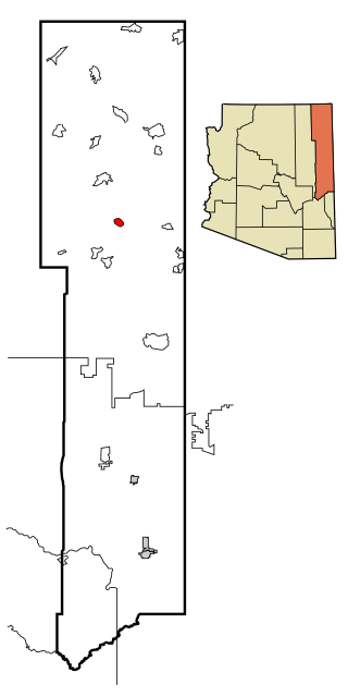
Nazlini is a census-designated place (CDP) in Apache County, Arizona, United States. The population was 489 at the 2010 census. Nearby are Nazlini Creek and Nazlini Canyon. Nazlini Canyon is the site of many Native American ruins and campsites that were abandoned when erosion made them unusable.

<span class="mw-page-title-main">Rosedale, California</span> Census-designated place in California, United States

Rosedale is a census-designated place (CDP) in Kern County, California, United States. The population was 14,058 at the 2010 census, up from 8,445 at the 2000 census. Formerly a country town 10 miles (16 km) west of Bakersfield, it is now surrounded by suburban housing and currently has the highest household income in Kern County, according to Census estimates.

<span class="mw-page-title-main">South Gate Ridge, Florida</span> Census-designated place in Florida, United States

South Gate Ridge is a census-designated place (CDP) in Sarasota County, Florida, United States. The population was 5,688 at the 2010 census. It is part of the Bradenton–Sarasota–Venice Metropolitan Statistical Area.

<span class="mw-page-title-main">Poipu, Hawaii</span> Census-designated place in Hawaii, United States

Poʻipū is a census-designated place (CDP) in Kauaʻi County on the southern side of the island of Kauaʻi in the U.S. state of Hawaiʻi. The population was 1,299 at the 2020 census. The town features a group of high-end hotels, resorts and two main shopping centers.

<span class="mw-page-title-main">Springvale, Maine</span> Place in Maine, United States

Springvale is a village and former census-designated place in the city of Sanford in York County, Maine, United States. The population was 3,292 at the 2010 census. It is part of the Portland–South Portland–Biddeford, Maine metropolitan statistical area. The CDP was abolished when the town of Sanford reincorporated as a city.

<span class="mw-page-title-main">Perryman, Maryland</span> Census-designated place in Maryland, United States

Perryman is an unincorporated community and census-designated place (CDP) in Harford County, Maryland, United States. The population was 2,342 at the 2010 census.

<span class="mw-page-title-main">St. James, Maryland</span> CDP in Maryland, United States

St. James is a census-designated place (CDP) in Washington County, Maryland, United States. The population was 1,657 at the 2000 census. It is also the home of St. James School, Hagerstown, a small, Episcopalian, boarding school. St. James was formerly named "Lydia."

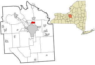
Munsons Corners is a hamlet and census-designated place (CDP) in Cortland County, New York, United States. The population was 2,728 at the 2010 census.

<span class="mw-page-title-main">Mattydale, New York</span> Census-designated place in New York, United States

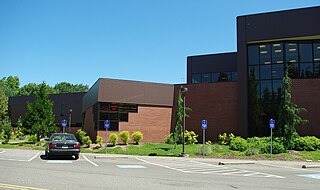
Mattydale is a hamlet in Onondaga County, New York, United States. The population was 6,446 at the 2010 census.

East Ithaca is a suburban community in Tompkins County, New York, United States. The population was 2,231 at the 2010 census.

<span class="mw-page-title-main">Forest Home, New York</span> CDP in New York, United States

Forest Home is a census-designated place (CDP) in Tompkins County, New York, United States. The population was 572 at the 2010 census.

Newfield is a census-designated place (CDP) in Tompkins County, New York, United States. The population was 759 at the 2010 census.

Northwest Ithaca is a census-designated place (CDP) in Tompkins County, New York, United States. The population was 1,115 at the 2000 census.

<span class="mw-page-title-main">South Hill, New York</span> CDP in New York, United States

South Hill is a census-designated place (CDP) in Tompkins County, New York, United States. The population was 7,245 at the 2020 census.

<span class="mw-page-title-main">Pigeon Creek, Ohio</span> CDP in Ohio, United States

Pigeon Creek is a census-designated place (CDP) in Summit County, Ohio, United States. The population was 945 at the 2000 census. It is part of the Akron metropolitan statistical area.

<span class="mw-page-title-main">Hayesville, Oregon</span> Unincorporated community in the state of Oregon, United States

Hayesville is a census-designated place and unincorporated community in Marion County, Oregon, United States, just outside the city limits of Salem but within the city's urban growth boundary. It is part of the Salem Metropolitan Statistical Area. For statistical purposes, the United States Census Bureau has defined Hayesville as a census-designated place (CDP). The census definition of the area may not precisely correspond to local understanding of the area with the same name. The population of the CDP was 21,891 at the 2020 census.

<span class="mw-page-title-main">Northwest Harborcreek, Pennsylvania</span> Census-designated place in Pennsylvania, United States

Northwest Harborcreek is a census-designated place (CDP) in Erie County, Pennsylvania, United States. The population was 8,949 at the 2010 census. It includes the unincorporated communities of Fairfield and Brookside and is part of the Erie Metropolitan Statistical Area.

<span class="mw-page-title-main">Sanatoga, Pennsylvania</span> Census-designated place in Pennsylvania, United States

Sanatoga is a community and census-designated place (CDP) that is located in Lower Pottsgrove Township, Montgomery County, Pennsylvania, United States. It is situated immediately east of the borough of Pottstown on U.S. Route 422.

<span class="mw-page-title-main">East Gaffney, South Carolina</span> Census-designated place in South Carolina, United States

East Gaffney is a census-designated place (CDP) in Cherokee County, South Carolina, United States. The population was 3,085 at the 2010 United States Census.

<span class="mw-page-title-main">Thomaston (CDP), Maine</span> Census-designated place in Maine, United States

Thomaston is a census-designated place (CDP) comprising the main village in the town of Thomaston in Knox County, Maine, United States. The population was 1,875 at the 2010 census, out of 2,781 in the town of Thomaston as a whole.

References

  1. "ArcGIS REST Services Directory". United States Census Bureau. Retrieved September 20, 2022.
  2. "US Gazetteer files: 2010, 2000, and 1990". United States Census Bureau. February 12, 2011. Retrieved April 23, 2011.
  3. "Census of Population and Housing". Census.gov. Retrieved June 4, 2016.
  4. "U.S. Census website". United States Census Bureau . Retrieved January 31, 2008.