Newfield, New York

Last updated

Newfield, New York
USA New York location map.svg
Red pog.svg
Newfield, New York
Location within the state of New York
Coordinates: 42°21′16″N76°36′1″W / 42.35444°N 76.60028°W / 42.35444; -76.60028
CountryUnited States
State New York
County Tompkins
Area
[1]
  Total58.97 sq mi (152.73 km2)
  Land58.84 sq mi (152.40 km2)
  Water0.13 sq mi (0.33 km2)
Elevation
1,601 ft (488 m)
Population
 (2020) [2]
  Total5,184 Increase2.svg
  Estimate 
(2021) [2]
5,107
  Density90.45/sq mi (34.92/km2)
Time zone UTC-5 (Eastern (EST))
  Summer (DST) UTC-4 (EDT)
ZIP code
14867
Area code 607
FIPS code 36-50254
GNIS feature ID0979263

Newfield is a town in Tompkins County, New York, United States. The population was 5,184 at the 2020 census. [2] The town's name is derived from the many unoccupied tracts of land that were once in the town.

Contents

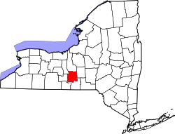
The Town of Newfield is in the southwest part of the county and is southwest of Ithaca, New York.

History

Newfield was formed, before Tompkins County was created, from the Town of Spencer (in Tioga County) in 1811 as the "Town of Cayuta." In 1822, the town assumed its current name.

During the Depression many abandoned farms were turned into conservation lands. Newfield contains one of New York State's few remaining covered bridges. The Newfield Covered Bridge was listed on the National Register of Historic Places in 2000. [3]

Geography

According to the United States Census Bureau, the town has a total area of 59.0 square miles (153 km2), of which, 58.9 square miles (153 km2) of it is land and 0.1 square miles (0.26 km2) of it (0.15%) is water.

The south and west town lines are the border of Schuyler County.

New York State Route 13 is a northeast to southwest highway in Newfield. Conjoined New York State Route 34 and New York State Route 96 form a north–south highway in the eastern part of the town.

Demographics

Historical population
CensusPop.Note
1830 2,664
1840 3,56733.9%
1850 3,8167.0%
1860 2,984−21.8%
1870 2,602−12.8%
1880 2,6080.2%
1890 2,214−15.1%
1900 1,902−14.1%
1910 1,509−20.7%
1920 1,456−3.5%
1930 1,451−0.3%
1940 1,5214.8%
1950 1,89124.3%
1960 2,19316.0%
1970 3,39054.6%
1980 4,40129.8%
1990 4,86710.6%
2000 5,1085.0%
2010 5,1791.4%
2020 5,1840.1%
2021 (est.)5,107 [2] −1.5%
U.S. Decennial Census [4]

As of the census [5] of 2000, there were 5,108 people, 2,052 households, and 1,352 families residing in the town. The population density was 86.8 inhabitants per square mile (33.5/km2). There were 2,203 housing units at an average density of 37.4 per square mile (14.4/km2). The racial makeup of the town was 96.06% White, 1.08% African American, 0.55% Native American, 0.37% Asian, 0.49% from other races, and 1.45% from two or more races. Hispanic or Latino of any race were 1.04% of the population.

There were 2,052 households, out of which 34.4% had children under the age of 18 living with them, 50.0% were married couples living together, 11.4% had a female householder with no husband present, and 34.1% were non-families. 25.0% of all households were made up of individuals, and 7.6% had someone living alone who was 65 years of age or older. The average household size was 2.49 and the average family size was 2.98.

In the town, the population was spread out, with 27.2% under the age of 18, 7.6% from 18 to 24, 31.5% from 25 to 44, 24.9% from 45 to 64, and 8.8% who were 65 years of age or older. The median age was 36 years. For every 100 females, there were 93.4 males. For every 100 females age 18 and over, there were 91.7 males.

The median income for a household in the town was $36,693, and the median income for a family was $43,147. Males had a median income of $29,353 versus $27,064 for females. The per capita income for the town was $17,735. About 6.9% of families and 9.1% of the population were below the poverty line, including 11.3% of those under age 18 and 3.0% of those age 65 or over.

Communities and locations in Newfield

Related Research Articles

<span class="mw-page-title-main">Chenango, New York</span> Town in New York, United States

Chenango is a town in Broome County, New York, United States. The population was 10,983 at the 2020 census.

<span class="mw-page-title-main">Fenton, New York</span> Town in New York, United States

Fenton is a town in Broome County, New York, United States. The population was 6,441 at the 2020 census. The town was named after Reuben Fenton, a governor of New York.

Coldspring is a town in Cattaraugus County, New York, United States. As of the 2020 census it had a population of 661. It is located in the southwest part of the county, west of the city of Salamanca.

<span class="mw-page-title-main">Jay, New York</span> Town in New York, United States

Jay is a town in Essex County, New York, United States. The population was 2,506 at the 2010 census. The town is named after John Jay, governor of New York when the town was formed.

<span class="mw-page-title-main">Salisbury, Herkimer County, New York</span> Town in New York, United States

Salisbury is a town in Herkimer County, New York, United States. The population was 1,958 at the 2010 census. The town is on the eastern edge of the county, north of the city of Little Falls. The northern part of the town is in the Adirondack Park.

<span class="mw-page-title-main">Verona, New York</span> Town in New York, United States

Verona is a town in southwestern Oneida County, New York, United States. The population was 6,293 at the 2010 census. The town was named after Verona, Italy.

<span class="mw-page-title-main">Carlton, New York</span> Town in New York, United States

Carlton is a town in Orleans County, New York, United States. The population was 2,994 at the 2010 census. The name is derived from Carleton, a shipbuilding district near Ottawa, Ontario, Canada.

<span class="mw-page-title-main">Richland, New York</span> Town in New York, United States

Richland is a town in the northeastern part of Oswego County, New York, United States. The population was 5,718 at the 2010 census.

<span class="mw-page-title-main">Moreau, New York</span> Town in New York, United States

Moreau is a town in Saratoga County, New York, United States. The population was 16,202 at the 2020 census. The town is located in the northeast part of the county, north of Saratoga Springs. Moreau is named after Jean Victor Moreau, a French general, who visited the area just before the town was formed. The town contains a village called South Glens Falls.

<span class="mw-page-title-main">Blenheim, New York</span> Town in New York, United States

Blenheim is a town in the southwestern part of Schoharie County, New York, United States. It is located east of Oneonta. At the 2020 census, the population was 308. The town was named after a land patent, which itself was named after the Battle of Blenheim.

<span class="mw-page-title-main">Pierrepont, New York</span> Town in New York, United States

Pierrepont is a town and hamlet in St. Lawrence County, New York, United States. As of the 2020 census, the town population was 2,523. It was named after Hezekiah Pierrepont, the early owner of much of the town's territory. The Town of Pierrepont is centrally located in the county and is southeast of Canton. A hamlet of the same name is in the town of Pierrepont. Pierrepont Manor, however, is located in Jefferson County.

Enfield is a town in Tompkins County, New York, United States. The population was 3,401 at the 2020 census.

<span class="mw-page-title-main">Cortlandt, New York</span> Town in New York, United States

Cortlandt is a town in Westchester County, New York, United States, located at the northwestern edge of the county, at the eastern terminus of the Bear Mountain Bridge. The town includes the villages of Buchanan and Croton-on-Hudson.

<span class="mw-page-title-main">Keeseville, New York</span> Hamlet and CDP in New York, United States

Keeseville is a hamlet in Clinton and Essex counties, New York, United States. The population was 1,815 at the 2010 census. The hamlet was named after the Keese family, early settlers from Vermont. It developed along the Ausable River, which provided water power for mills and industrial development.

<span class="mw-page-title-main">Delhi, New York</span> Town in New York, United States

Delhi is a town in Delaware County, New York, United States. The population was 4,795 at the 2020 census. The town is in the east-central part of the county and contains the village of Delhi. The State University of New York at Delhi is located in the town.

<span class="mw-page-title-main">Manlius, New York</span> Town in New York, United States

Manlius is a town to the east of Syracuse in Onondaga County. As of the 2020 Census, the population was 33,712, making it the third largest suburb in metropolitan Syracuse. In 2005, the town was ranked 98th on CNN's list of Best Places to Live.

<span class="mw-page-title-main">Norfolk, New York</span> Town in New York, United States

Norfolk is a town in St. Lawrence County in the U.S. state of New York. The town is in the northern part of the county and is north of Potsdam. The population was 4,453 at the 2020 census.

Spencer is a town in Tioga County, New York, United States. The population was 2,976 at the 2020 census. The town and its primary village are named after Ambrose Spencer. It lies on the western border of the county and is south of Ithaca. Inside the town is the Village of Spencer. The village of Candor borders the town to the east and southeast, with Waverly to the southwest and Van Etten to the west, while Danby is to the north.

Portage is a town in the southwest corner of Livingston County, New York, United States. The town is at the south end of Letchworth State Park. The name of the town stems from the need to portage (carry) canoes around the falls of the Genesee River. The population of Portage was 884 at the 2010 census.

<span class="mw-page-title-main">Gardiner, New York</span> Town in New York, United States

Gardiner is a town in the south-central part of Ulster County, New York, United States. The population was 5,610 at the 2020 census.

References

  1. "2016 U.S. Gazetteer Files". United States Census Bureau. Retrieved July 5, 2017.
  2. 1 2 3 4 Bureau, US Census. "City and Town Population Totals: 2020—2021". Census.gov. US Census Bureau. Retrieved October 7, 2022.
  3. "National Register Information System". National Register of Historic Places . National Park Service. March 13, 2009.
  4. "Census of Population and Housing". Census.gov. Retrieved June 4, 2015.
  5. "U.S. Census website". United States Census Bureau . Retrieved January 31, 2008.
  6. "Newfield | New York State Covered Bridge Society" . Retrieved February 15, 2020.
  7. "Newfield School District". newfieldschools.org. Retrieved February 15, 2020.