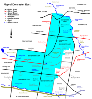
Doncaster East is a suburb of Melbourne, Victoria, Australia, 22 km north-east of Melbourne's Central Business District in the local government area of the City of Manningham. At the 2011 Census, Doncaster East had a population of 27,047.

Prospect is the seat of the City of Prospect and an inner northern suburb of greater Adelaide. It is located 5 km (3.1 mi) north of Adelaide's centre.
Cardiff is a suburb of the City of Lake Macquarie, New South Wales, Australia. It is located 13 kilometres (8 mi) west-southwest of Newcastle's central business district in the City of Lake Macquarie North Ward.
Rossmore is a suburb of Sydney, in the state of New South Wales, Australia.
Kemps Creek is a suburb of Sydney, in the state of New South Wales, Australia. It is approximately 39 kilometres (24 mi) west of the Sydney central business district, in the local government areas of the City of Penrith and City of Liverpool. It is part of the Greater Western Sydney region.

Cartwright is a suburb in south-western Sydney, in the state of New South Wales, Australia 38 kilometres south-west of the Sydney central business district, in the local government area of the City of Liverpool.

Ningi is a town and locality in the Moreton Bay Region, Queensland, Australia. It is near Caboolture.

Bailup is a Western Australian locality and rural residential estate located 62 kilometres (39 mi) north-east of the state capital, Perth, along Toodyay Road. The area is split between the Shire of Toodyay and Shire of Mundaring, the latter of which contains most of the land area.
The State Parks of New South Wales are eighteen protected areas in New South Wales, Australia reserved for camping, water sports and recreational uses. State Parks are maintained by the New South Wales Department of Lands and managed by community trust boards.

Collingwood Heights is a north-eastern suburb of Albany, Western Australia, between the Albany city centre and Emu Point within the local government area of the City of Albany.
East Tamworth is a suburb of Tamworth, New South Wales, Australia, in the city's east. It is located between the suburbs of North Tamworth, Tamworth CBD and the satellite suburb of Nemingha. East Tamworth is one of the oldest settled areas of Tamworth, and therefore is known for its wide streets and historical buildings and homes. Many of these historical buildings are the highest valued properties in Tamworth. East Tamworth is home to ANZAC Park, Tamworth Public School and Calrossy Anglican School for Girls.
South Tamworth is a suburb of Tamworth, New South Wales, Australia and is situated south from the cities Central Business District. It is a largely residential suburb and is a mixture of both new housing estates and well established estates. Southgate Shopping Centre, Robert Street Shopping Centre, Chaffey Park and Hyman Park are all located in South Tamworth.
Oxley Vale is a suburb of Tamworth, New South Wales, Australia, which runs either side of Manilla road. It is between the suburbs of North Tamworth and the satellite suburb of Hallsville. Oxley Vale is a largely residential suburb. Nazareth House nursing house is located there.

Hillvue is a suburb of Tamworth, New South Wales, Australia. It is a largely residential suburb of Tamworth and is south of South Tamworth. It has the second highest population estimate of any area of Tamworth, with over six thousand people in 2011.

Nemingha is an outer suburb of Tamworth, New South Wales, Australia, 5 km south of the Tamworth Central Business District on the New England Highway. Northwest of Nemingha is East Tamworth and the Tamworth Central Business District.
Kingswood is an outer-suburb of Tamworth, New South Wales, located south of the city. It is located off the New England Highway and is located south of the suburb Hillvue and is a largely rural residential suburb. North East/East of Kingswood is the suburb Calala.
Warral is a small locality south of Tamworth in the New England region of New South Wales, Australia. It lies on the Werris Creek Road and the Main North railway line. A station was located there between 1910 and 1975.
Port Curtis is a suburb of Rockhampton in the Rockhampton Region, Queensland, Australia.

Hallsville is a small satellite town of Tamworth located 12.5 km along the Manilla Road north of Tamworth. The suburb is part of the Moore Creek-Daruka-Tintinhull-Hallsville district, where settlement was historically known to start in the mid-1800s. Agriculture has been one of the major sources of livelihood in the area as well as grazing and crop production.


