West Tamworth, New South Wales

Last updated

West Tamworth
Tamworth,  New South Wales
St Paul's Anglican Church West Tamworth.jpg
St Paul's Anglican Church, West Tamworth
Australia New South Wales location map blank.svg
Red pog.svg
West Tamworth
Coordinates 31°06′S150°55′E / 31.100°S 150.917°E / -31.100; 150.917
Population5,417 (2021 census) [1]
Postcode(s) 2340
LGA(s) Tamworth Regional Council
State electorate(s) Tamworth,
Federal division(s) New England
Suburbs around West Tamworth:
North Tamworth Tamworth Central Business District
Taminda West Tamworth
South Tamworth

West Tamworth is a suburb of Tamworth, New South Wales, Australia, in the city's west. It is between South Tamworth and Taminda (Tamworth Industrial Area). It is an important commercial and residential area of Tamworth. In West Tamworth is the important commercial area of Bridge Street, which is one of the main roads connecting the northern side of Tamworth with the southern. The Oxley Highway runs through part of West Tamworth.

Contents

Commercial area

Bridge Street is an important commercial area for Tamworth and many businesses serving the southern side and whole of Tamworth are located upon it. Bridge Street becomes Brisbane Street on the northern side of the Peel River, however Bridge Street is not viewed as a part of the Tamworth Central Business District> Instead, it is viewed as a separate commercial area. Tamworth Shopping World is located on Bridge Street and is a major commercial centre in Tamworth.

Clubs

West Tamworth League Club is located in West Tamworth, and is home of the West Tamworth Lions rugby league club. It is also a popular venue during the Tamworth Country Music Festival in January and artists such as John Butler Trio, The Baileys, John Williamson, Pete Murray, The Waifs, Missy Higgins, Grinspoon, Xavier Rudd and Kasey Chambers have all played at the club. Wests and Wests' Diggers (Kable Avenue in the CBD) are part of the Wests Entertainment Group.

Sport

The Tamworth netball courts, baseball and softball fields are located riverside on the western side of the Peel River. This area is in both West Tamworth and the industrial suburb Taminda. The Tamworth Touch fields are also located riverside in West Tamworth. The West Tamworth Lions rugby league club play at the West Tamworth Leagues Club at their fields are known as Scully Park. Former Australian representative and St. George, player Nathan Blacklock played one game for the West Lions in early 2007. The Tamworth Pirates rugby club play at grounds near the West Lions Scully Park ground, and across the road from the West and South Tamworth Scully Park Olympic Pool. This Olympic pool is council owned and many swimmers use it for training and competition.

Rivalries

There is a rich tradition of rivalries in Rugby league and Rugby Union between West Tamworth and North Tamworth as the suburbs' football teams represent the western and northern suburbs of Tamworth respectively. In rugby league this rivalry is between the West Tamworth Lions and the North Tamworth Bears, with their clash drawing large crowds each year. In rugby union this rivalry is between the Pirates rugby club and the Tamworth Magpies, with their clash each year also drawing large crowds.

Coledale

Coledale is a section of West Tamworth known to the residents as the area with Gunnedah Road to the north, Duri road to the east and Cole road to the west. [2] Coledale was originally a subdivision named after the late Tamworth mayor Stan Cole. Coledale is notorious for drugs, crime and poverty. Coledale is home to many first nations residents and attracts many racist and derogatory nicknames such as ''Vegimite Village". [3] Coledale has a population of 3,068 down 2.8% from 2001, there are 884 Indigenous residents which make up 28.8% of the population. Coledale underperforms in almost all metrics with a median income 25% lower, and an unemployment rate 3 times higher than the national average. Coledale also has more people without formal educational qualifications, more labourers and less professional workers than the rest of Australia. [4]

Coledale also has a significant amount of social housing consisting of 408 dwellings managed by different authorities. Coledale is a hotspot for crime [5] [6] and various plans by Tamworth Regional Council have been made to reduce crime including their 2017-2022 Crime Prevention Plan. [4] [7]

Schools

Related Research Articles

<span class="mw-page-title-main">Gosford</span> Suburb of Central Coast, New South Wales, Australia

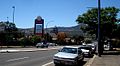
Gosford is a waterfront city at the northern end of Brisbane Water on the Central Coast in the state of New South Wales, Australia. The Gosford waterfront is known for its boating and scenic views on the shores of Brisbane Water. Gosford is the main commercial hub and gateway of the Central Coast. It is situated approximately 77 km (48 mi) north of Sydney and 86 km (53 mi) south of Newcastle. Gosford is located in the local government area of the Central Coast Council.

<span class="mw-page-title-main">Tamworth, New South Wales</span> City in New South Wales, Australia

Tamworth is a city and administrative centre of the north-western region of New South Wales, Australia. Situated on the Peel River within the local government area of the Tamworth Regional Council, it is the largest and most populated city in the region, with a population of 63,920 in 2021, making it the second largest inland city in New South Wales. Tamworth is 318 km (198 mi) from the Queensland border and is located almost midway between Brisbane and Sydney.

<span class="mw-page-title-main">Mascot, New South Wales</span> Suburb of Sydney, New South Wales, Australia

Mascot is a suburb in the Inner-South of Sydney, in the state of New South Wales, Australia. Mascot is located 7 kilometres south of the Sydney central business district and is one of the administrative centres of the Bayside Council. A small part of Mascot is located in the Inner West Council. Mascot is on the north-west side of Botany Bay and contains Sydney Airport.

<span class="mw-page-title-main">Rhodes, New South Wales</span> Suburb of Sydney, New South Wales, Australia

Rhodes is an Inner West suburb of Sydney, in the state of New South Wales, Australia. Rhodes is located 12 kilometres west of the Sydney central business district, in the local government area of the City of Canada Bay. It was formerly part of Concord Municipality until a merger with Drummoyne Council to form Canada Bay in December 2000.

<span class="mw-page-title-main">Hurstville, New South Wales</span> Suburb of Sydney, New South Wales, Australia

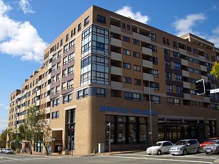
Hurstville is a suburb in Southern Sydney, New South Wales, Australia. It is 16 km (9.9 mi) south of the Sydney CBD and is part of the St George area. Hurstville is the administrative centre of the local government area of the Georges River Council.

<span class="mw-page-title-main">Caringbah</span> Suburb of Sydney, New South Wales, Australia

Caringbah is a suburb in Southern Sydney, in the state of New South Wales, Australia. Caringbah is 24 kilometres (15 mi) south of the Sydney central business district in the local government area of Sutherland Shire.

<span class="mw-page-title-main">Leichhardt, New South Wales</span> Suburb of Sydney, New South Wales, Australia

Leichhardt is a suburb in the Inner West of Sydney, in the state of New South Wales, Australia. Leichhardt is located 5 kilometres west of the Sydney central business district (CBD) and is the administrative centre for the local government area (LGA) of the Inner West Council. The suburb is bordered by Haberfield to the west, Annandale to the east, Lilyfield to the north and Petersham, Lewisham and Stanmore to the south.

<span class="mw-page-title-main">North Sydney, New South Wales</span> Suburb of Sydney, New South Wales, Australia

North Sydney is a suburb and major commercial district on the Lower North Shore of Sydney, New South Wales, Australia. It is located three kilometres north of the Sydney central business district and is the administrative centre for the local government area of North Sydney Council.

<span class="mw-page-title-main">West Wyalong</span> Town in New South Wales, Australia

West Wyalong is the main town of the Bland Shire in the Riverina region of New South Wales, Australia. Located 467 kilometres (290 mi) west of Sydney as well as being 262 m (860 ft) above sea level, it is situated on the crossroads of the Newell Highway between Melbourne and Brisbane, and the Mid-Western Highway between Sydney and Adelaide.

<span class="mw-page-title-main">Stockton, New South Wales</span> Suburb of Newcastle, New South Wales, Australia

Stockton is a suburb of Newcastle, New South Wales, Australia, located 600 m (0.4 mi) from Newcastle's central business district. It is the only residential suburb of the City of Newcastle that lies north of the Hunter River.

<span class="mw-page-title-main">Yagoona, New South Wales</span> Suburb of Sydney, New South Wales, Australia

Yagoona, a suburb of the local government area City of Canterbury-Bankstown, is located 20 kilometres south-west of the Sydney central business district, in the state of New South Wales, Australia. It is a part of the South-western Sydney region. Yagoona is an Aboriginal word meaning 'now' or 'today'. It was the site of the first McDonald's restaurant to open in Australia in December 1971.

<span class="mw-page-title-main">Quirindi</span> Town in New South Wales, Australia

Quirindi is a small town on the North West Slopes region of New South Wales, Australia, in Liverpool Plains Shire. At the 2016 census, Quirindi had a population of 3,444. It is the nearest link to Gunnedah to the northwest and Tamworth to the north. The local economy is based on agriculture, with broadacre farming dominant on the black soil plains to the west and livestock grazing in the hilly eastern part of the district.

<span class="mw-page-title-main">Drummoyne</span> Suburb of Sydney, New South Wales, Australia

Drummoyne is a suburb in the Inner West of Sydney, in the state of New South Wales, Australia. Drummoyne is six kilometres west of the Sydney central business district and is the administrative centre for the local government area of the City of Canada Bay.

<span class="mw-page-title-main">Calala, New South Wales</span> Suburb of Tamworth, New South Wales, Australia

Calala is a suburb of the Northern New South Wales city of Tamworth, administered by Tamworth Regional Council. In the 2016 census, Calala had a population of 3,927.

Group 4 is a rugby league competition in the New England and north west area of New South Wales, run under the auspices of the Country Rugby League.

<span class="mw-page-title-main">Tamworth Regional Council</span> Local government area in New South Wales, Australia

Tamworth Regional Council is a local government area in the New England region of New South Wales, Australia. The area under administration is located adjacent to the New England Highway and the Main North railway line. It was established in March 2004 through the amalgamation of the former City of Tamworth with surrounding shires of Barraba, Manilla, Nundle and Parry.

<span class="mw-page-title-main">Nundle, New South Wales</span> Town in New South Wales, Australia

Nundle is a village in the New England region of New South Wales, Australia. It was formerly the centre of Nundle Shire, but most of this area, including the village of Nundle, was absorbed into Tamworth Regional Council in 2004. The village is 400 km north of Sydney and about 56 km south east of Tamworth past Chaffey Dam via a good sealed road. In the 2006 census Nundle had a population of 289. Nundle is located at the southern end of Fossickers Way.

<span class="mw-page-title-main">Concord Oval</span> Rugby stadium in Sydney

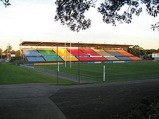
Concord Oval, is a rugby football stadium in the inner-west Sydney suburb of Concord, Australia. The stadium is able to hold 5,000 people as of November 2022, down from 20,000 when the Concord Oval was opened in 1985. As of 2022, it is used mostly for rugby union matches and hosted eight matches during the 1987 Rugby World Cup. It is also a venue for soccer matches and local rugby league matches.

<span class="mw-page-title-main">North Tamworth, New South Wales</span> Suburb of Tamworth, New South Wales, Australia

North Tamworth is a suburb of Tamworth, New South Wales, Australia, in the city's north. It is on the northerly side of the Peel River between the suburbs of East Tamworth and Oxley Vale. North of North Tamworth are the satellite suburbs Hills Plain, and Moore Creek. The Tamworth Base Hospital, Tamara Private Hospital, and many medical professionals' clinics. The suburb contains Northgate Shopping Centre and many sporting fields.

<span class="mw-page-title-main">Northern Sydney</span> Region of Sydney in New South Wales, Australia

Northern Sydney is a large metropolitan area in Greater Sydney, New South Wales, Australia on the north shore of Sydney Harbour and Parramatta River. The region embraces suburbs in Sydney's north-east, north and inner north west. Northern Sydney is divided into distinctive regions such as the North Shore, Northern Beaches and Forest District.

References

  1. Australian Bureau of Statistics (31 October 2012). "West Tamworth". 2011 Census QuickStats. Retrieved 10 April 2013. OOjs UI icon edit-ltr-progressive.svg
  2. The Northern Daily Leader (18 July 2012). "Coledale needs another name". The Northern Daily Leader. p. 1. Retrieved 27 December 2023.
  3. Clarke, Alan (4 June 2018). "Footsteps on the Tracks". ABC News. Retrieved 27 December 2023.
  4. 1 2 https://apps.planningportal.nsw.gov.au/prweb/PRRestService/DocMgmt/v1/PublicDocuments/DATA-WORKATTACH-FILE%20PEC-DPE-EP-WORK%20PP-2020-1768!20201127T232133.291%20GMT
  5. Chillingworth, Breanna (31 August 2019). "Coledale ban: 31-year-old man banned from entering Coledale suburb in Tamworth in sentencing in Tamworth court". The Northern Daily Leader. p. 1. Retrieved 27 December 2023.
  6. Johanna, McOwen (5 May 2015). "NSW Governor concerned about ice epidemic in regional and rural areas". ABC News. p. 1. Retrieved 27 December 2023.
  7. https://www.tamworth.nsw.gov.au/ArticleDocuments/418/Community%20Safety%20and%20Crime%20Prevention%20Plan%202023-28.pdf.aspx
Preceding stationFormer ServicesFollowing station
Tamworth
towards Wallangarra
Main North Line Warral
towards Sydney