
Tamworth is a city and the administrative centre of the North Western region of New South Wales, Australia. Situated on the Peel River within the local government area of Tamworth Regional Council, it is the largest and most populated city in the North Western region, with a population of 42,872 in June 2018, making it the second largest inland city in New South Wales. Tamworth is 318 km (198 mi) from the Queensland border, and it is located almost midway between Brisbane and Sydney.

Beverly Hills is a southern suburb of Sydney, in the state of New South Wales, Australia. Beverly Hills is located 15 kilometres southwest of the Sydney central business district and is part of the St George area and is split between the local government areas of the Georges River Council and the City of Canterbury-Bankstown. It is often colloquially referred to as "Bevo". The postcode is 2209, which it shares with neighbouring Narwee.

Hurlstone Park is a suburb in the Inner West of Sydney, New South Wales, Australia. Hurlstone Park is located nine kilometres south-west of the Sydney central business district and is mostly in the local government area of the City of Canterbury-Bankstown, and partly in the Inner West Council. The suburb is bounded by: the Cooks River to the south, Garnet Street to the east, New Canterbury Road to the north, Canterbury Road to the north-west, and Church Street to the west.
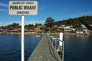
Saratoga is a residential south-eastern village and suburb of the Central Coast region of New South Wales, Australia, located on a peninsula of Brisbane Water and part of the Central Coast Council local government area. The suburb is characterised by its largely settled shoreline, with houses extending up coastal slopes to the base of the tall hills that comprise the core of the peninsula.

Turramurra is a suburb on the Upper North Shore of Sydney, in the state of New South Wales, Australia. It is located 16 kilometres (10 mi) north-west of the Sydney central business district, in the local government area of Ku-ring-gai Council. It shares the postcode of 2074 with the adjacent suburbs of North Turramurra, South Turramurra and Warrawee.
Eastwood is a suburb of Sydney, Australia. Eastwood is located 17 kilometres north-west of the Sydney central business district in the local government areas of the City of Ryde and the City of Parramatta. Eastwood is in the Northern Sydney region.

Winmalee is a town in New South Wales, Australia. Winmalee is located 80 kilometres west of Sydney, in the local government area of the City of Blue Mountains. At the 2011 census, Winmalee had a population of 6,593.

Collaroy is a suburb in northern Sydney, in the state of New South Wales, Australia. Collaroy is 22 kilometres north-east of the Sydney central business district, in the local government area of Northern Beaches Council. It is part of the Northern Beaches region. Nicknamed "The Roy" by many of the locals.

North Turramurra is a suburb on the Upper North Shore of Sydney, in the state of New South Wales, Australia. North Turramurra is located 20 kilometres (12 mi) north-west of the Sydney central business district, in the local government area of Ku-ring-gai Council. Turramurra and South Turramurra are separate suburbs.

Telopea is a suburb of Greater Western Sydney, in the state of New South Wales, Australia. Telopea is located 23 kilometres north-west of the Sydney central business district, in the local government area of the City of Parramatta. The suburb is bordered by Kissing Point Road to the south and Pennant Hills Road to the north.

St Clair is a suburb of Sydney, in the state of New South Wales, Australia. It is 39 kilometres west of the Sydney central business district, in the local government area of the City of Penrith and is part of the Greater Western Sydney region. St Clair is within view of the Blue Mountains.
Horsley Park is a suburb of Sydney in the state of New South Wales, Australia. Horsley Park is located 39 kilometres west of the Sydney central business district in the local government area of the City of Fairfield. Horsley Park is part of the Greater Western Sydney region. It is a semi-rural suburb, located 5 km west of Wetherill Park and 11 km north-west of Fairfield.

Kootingal is a town in New South Wales, Australia in the Tamworth Regional Council area. It is commonly called a satellite suburb of Tamworth because of its closeness and the fact that its residents use Tamworth's services. Founded as an Aboriginal mission, Kootingal traces its name roots to the local Aboriginal Kamilaroi language. At the 2016 census, Kootingal had a population of 2,126 people.

Tamworth Regional Council is a local government area in the New England region of New South Wales, Australia. The area under administration is located adjacent to the New England Highway and the Main North railway line. It was established in March 2004 through the amalgamation of the former City of Tamworth with surrounding shires of Barraba, Manilla, Nundle and Parry.
Telarah is a suburb in the City of Maitland, New South Wales, Australia. The suburb was formerly known as Homeville, however use of this name was abandoned in the 1950s. It is located on the New England Highway and is also the site of a major rail junction, where the North Coast line and the once extensive, privately owned South Maitland Railway system meet the Main North line. A station on the North Coast line opened in 1911 and is served by NSW TrainLink's Hunter Line, with services to Newcastle and Dungog. Telarah has its own fire brigade as well as bowling club, supermarket, pharmacy, takeaway shop and newsagents.

Bundarra is a small town on the Northern Tablelands of New South Wales, Australia. The town is located on Thunderbolts Way and on the banks of the Gwydir River, in the Uralla Shire local government area, 563 kilometres (350 mi) from the state capital, Sydney. At the 2016 census, Bundarra had a population of 394 and the surrounding area had 676 persons.

Hillvue is a suburb of Tamworth, New South Wales, Australia. It is a largely residential suburb of Tamworth and is south of South Tamworth. It has the second highest population estimate of any area of Tamworth, with over six thousand people in 2011.
Maryland is a suburb of Newcastle, New South Wales, Australia, located 14 kilometres (9 mi) from Newcastle's central business district. It is part of the City of Newcastle local government area.
Somerton is a village between Tamworth and Gunnedah on the Oxley Highway in northern New South Wales Australia. In the 2016 census, there were 277 people in Somerton. Somerton Village adjoins the plentiful Peel River.
Caddens is a suburb of Sydney, in the state of New South Wales in Australia. It is a new masterplanned residential neighbourhood located 45 kilometres west of the Sydney central business district, in the local government area of the City of Penrith featuring views of the scenic Blue Mountains. The suburb's postcode is 2747.


