Denison, Kansas

Last updated

Denison, Kansas
Jackson County Kansas Incorporated and Unincorporated areas Denison Highlighted.svg
Location within Jackson County and Kansas
Map of Jackson Co, Ks, USA.png
Coordinates: 39°23′38″N95°37′42″W / 39.39389°N 95.62833°W / 39.39389; -95.62833 [1]
Country United States
State Kansas
County Jackson
Township Garfield & Cedar
Founded1887
Incorporated 1904
Area
[2]
  Total0.11 sq mi (0.29 km2)
  Land0.11 sq mi (0.29 km2)
  Water0.00 sq mi (0.00 km2)
Elevation
[1]
1,056 ft (322 m)
Population
 (2020) [3]
  Total146
  Density1,300/sq mi (500/km2)
Time zone UTC-6 (CST)
  Summer (DST) UTC-5 (CDT)
ZIP code
66419
Area code 785
FIPS code 20-17625
GNIS ID 2394515 [1]

Denison is a city in Jackson County, Kansas, United States. [1] As of the 2020 census, the population of the city was 146. [3]

Contents

History

19th century

Denison was founded as a result of the Kansas City, Wyandotte and Northwestern Railway laying tracks that would connect the communities of Valley Falls and Holton. The railroad was slated to come through one mile south of an existing village, Tippinville, and in September 1887, A.D. Walker and Hollis Tucker, land speculators, laid out lots for a new town, which was named after Tucker's hometown, Denison, Ohio. Most of the houses and two churches in Tippinville were bodily moved to the new townsite, which is primarily in Garfield Township, with a small portion in Cedar Township (it was all Cedar Township at first). By August 1890, Tippinvile had been officially vacated and by 1894 Denison had a population of 150.[ citation needed ]

A number of Civil War veterans are buried in the Denison Cemetery (and nearby cemeteries, North and South Cedar Cemeteries), and there is one veteran of the Mexican–American War, G. W. White, buried at Denison. Eliza Cody Myers (Mrs. George Myers), sister of William F. "Buffalo Bill" Cody is also buried there. It was a truly exciting event for school children when Buffalo Bill came to Denison to visit his niece, Nellie Myers Copas, and her family.[ citation needed ]

A post office, named North Cedar, was established in 1867. The first school, built of logs, was established in 1858 south of present-day Denison, on the site of the North Cedar Cemetery. The first church in the area, of the Christian denomination was founded in 1856 by the Rev. J.T. Gardiner. The Reformed Presbyterian Church was established in 1871, with the Rev. J.S.T. Milligan the founding pastor; the United Presbyterian Church, in 1880; and the Denison Methodist Episcopal Church, in 1889. The Christian, United Presbyterian and Methodist churches united to become the Denison Union Church in 1958, and later became the Denison Bible Church. The Denison Christian Church building, erected in 1878, now houses the Denison Historical Museum, and is one of three Jackson Co. buildings included in the State Register of Historic Places.[ citation needed ]

20th century

The Denison State Bank was founded in 1901, and after its second robbery, in 1938, was moved to Holton, the county seat, where it thrives today under the same name. The Denison Rural High School was established in 1916, and a brick building was erected. It burned in 1938 and a new school building was completed in 1941. Due to school district unification, the last class to graduate from Denison High School was in 1969. However the school continued to serve lower grades until it closed its doors in 1990. Area students now attend schools in Holton.[ citation needed ]

Geography

According to the United States Census Bureau, the city has a total area of 0.11 square miles (0.28 km2), all of it land. [4]

Demographics

Historical population
CensusPop.Note
1910 295
1920 240−18.6%
1930 202−15.8%
1940 176−12.9%
1950 166−5.7%
1960 18410.8%
1970 24834.8%
1980 231−6.9%
1990 225−2.6%
2000 2312.7%
2010 187−19.0%
2020 146−21.9%
U.S. Decennial Census

Denison is part of the Topeka, Kansas Metropolitan Statistical Area.

2020 census

The 2020 United States census counted 146 people, 63 households, and 42 families in Denison. [5] [6] The population density was 1,303.6 per square mile (503.3/km2). There were 82 housing units at an average density of 732.1 per square mile (282.7/km2). [6] [7] The racial makeup was 89.73% (131) white or European American (89.04% non-Hispanic white), 0.68% (1) black or African-American, 2.74% (4) Native American or Alaska Native, 0.0% (0) Asian, 0.0% (0) Pacific Islander or Native Hawaiian, 0.0% (0) from other races, and 6.85% (10) from two or more races. [8] Hispanic or Latino of any race was 0.68% (1) of the population. [9]

Of the 63 households, 31.7% had children under the age of 18; 42.9% were married couples living together; 23.8% had a female householder with no spouse or partner present. 28.6% of households consisted of individuals and 17.5% had someone living alone who was 65 years of age or older. [6] The average household size was 1.9 and the average family size was 2.8. [10] The percent of those with a bachelor’s degree or higher was estimated to be 2.1% of the population. [11]

22.6% of the population was under the age of 18, 11.6% from 18 to 24, 24.0% from 25 to 44, 28.1% from 45 to 64, and 13.7% who were 65 years of age or older. The median age was 38.0 years. For every 100 females, there were 94.7 males. [6] For every 100 females ages 18 and older, there were 101.8 males. [6]

The 2016-2020 5-year American Community Survey estimates show that the median household income was $48,889 (with a margin of error of +/- $20,930) and the median family income was $85,000 (+/- $40,191). [12] The median income for those above 16 years old was $24,844 (+/- $12,517). [13] Approximately, 11.5% of families and 24.0% of the population were below the poverty line, including 35.3% of those under the age of 18 and 12.5% of those ages 65 or over. [14] [15]

2010 census

As of the census [16] of 2010, there were 187 people, 76 households, and 50 families residing in the city. The population density was 1,700.0 inhabitants per square mile (656.4/km2). There were 87 housing units at an average density of 790.9 per square mile (305.4/km2). The racial makeup of the city was 96.3% White, 0.5% Native American, and 3.2% from two or more races. Hispanic or Latino of any race were 1.1% of the population.

There were 76 households, of which 31.6% had children under the age of 18 living with them, 46.1% were married couples living together, 11.8% had a female householder with no husband present, 7.9% had a male householder with no wife present, and 34.2% were non-families. 30.3% of all households were made up of individuals, and 11.8% had someone living alone who was 65 years of age or older. The average household size was 2.46 and the average family size was 2.94.

The median age in the city was 31.8 years. 27.8% of residents were under the age of 18; 8.6% were between the ages of 18 and 24; 24.6% were from 25 to 44; 26.8% were from 45 to 64; and 12.3% were 65 years of age or older. The gender makeup of the city was 46.5% male and 53.5% female.

2000 census

As of the census [17] of 2000, there were 231 people, 82 households, and 62 families residing in the city. The population density was 1,973.8 inhabitants per square mile (762.1/km2). There were 88 housing units at an average density of 751.9 per square mile (290.3/km2). The racial makeup of the city was 93.94% White, 1.30% African American, 2.60% Native American, 1.73% from other races, and 0.43% from two or more races. Hispanic or Latino of any race were 1.73% of the population.

There were 82 households, out of which 34.1% had children under the age of 18 living with them, 59.8% were married couples living together, 12.2% had a female householder with no husband present, and 23.2% were non-families. 19.5% of all households were made up of individuals, and 11.0% had someone living alone who was 65 years of age or older. The average household size was 2.77 and the average family size was 3.19.

In the city, the population was spread out, with 28.1% under the age of 18, 12.1% from 18 to 24, 24.7% from 25 to 44, 23.8% from 45 to 64, and 11.3% who were 65 years of age or older. The median age was 33 years. For every 100 females, there were 100.9 males. For every 100 females age 18 and over, there were 102.4 males.

The median income for a household in the city was $27,500, and the median income for a family was $33,250. Males had a median income of $24,375 versus $17,778 for females. The per capita income for the city was $13,378. About 9.3% of families and 15.0% of the population were below the poverty line, including 36.6% of those under the age of eighteen and 5.6% of those 65 or over.

Education

The community is served by Holton USD 336 public school district.

Related Research Articles

<span class="mw-page-title-main">Isabel, Kansas</span> City in Kiowa County, Kansas

Isabel is a city in Barber County, Kansas, United States. As of the 2020 census, the population of the city was 68.

<span class="mw-page-title-main">Powhattan, Kansas</span> City in Brown County, Kansas

Powhattan is a city in Brown County, Kansas, United States. As of the 2020 census, the population of the city was 69.

<span class="mw-page-title-main">Green, Kansas</span> City in Clay County, Kansas

Green is a city in Clay County, Kansas, United States. As of the 2020 census, the population of the city was 95.

<span class="mw-page-title-main">Glasco, Kansas</span> City in Cloud County, Kansas

Glasco is a city in Cloud County, Kansas, United States. As of the 2020 census, the population of the city was 441.

<span class="mw-page-title-main">Waverly, Kansas</span> City in Coffey County, Kansas

Waverly is a city in Coffey County, Kansas, United States. As of the 2020 census, the population of the city was 574.

<span class="mw-page-title-main">Hepler, Kansas</span> City in Crawford County, Kansas

Hepler is a city in Crawford County, Kansas, United States. As of the 2020 census, the population of the city was 90.

<span class="mw-page-title-main">Norcatur, Kansas</span> City in Decatur County, Kansas

Norcatur is a city in Decatur County, Kansas, United States. As of the 2020 census, the population of the city was 159.

<span class="mw-page-title-main">Denton, Kansas</span> City in Doniphan County, Kansas

Denton is a city in Doniphan County, Kansas, United States. As of the 2020 census, the population of the city was 130.

<span class="mw-page-title-main">Lecompton, Kansas</span> City in Kansas, United States

Lecompton is a city in Douglas County, Kansas, United States. As of the 2020 census, the population of the city was 588. Lecompton was the de jure territorial capital of Kansas from 1855 to 1861, and the Douglas County seat from 1855 to 1858. Anti-slavery Lawrence became the de facto capital during the latter part of this period, when the county seat was moved there. This time period was known as Bleeding Kansas, due to the violence perpetrated by the pro-slavery, and to a lesser extent the anti-slavery, factions in the eastern part of the state. Lecompton was a hotbed of pro-slavery sentiment during the mid-1800s.

<span class="mw-page-title-main">Holton, Kansas</span> City in Jackson County, Kansas

Holton is a city in and the county seat of Jackson County, Kansas, United States. As of the 2020 census, the population of the city was 3,401.

<span class="mw-page-title-main">Dighton, Kansas</span> City in Lane County, Kansas

Dighton is a city in and the county seat of Lane County, Kansas, United States. As of the 2020 census, the population of the city was 960. Dighton is named for Dick Dighton, a surveyor.

<span class="mw-page-title-main">Pleasanton, Kansas</span> City in Kansas, United States

Pleasanton is a city in Linn County, Kansas, United States. As of the 2020 census, the population of the city was 1,208.

<span class="mw-page-title-main">Meade, Kansas</span> City in Meade County, Kansas

Meade is a city in and the county seat of Meade County, Kansas, United States. As of the 2020 census, the population of the city was 1,505.

<span class="mw-page-title-main">Corning, Kansas</span> City in Nemaha County, Kansas

Corning is a city in Nemaha County, Kansas, United States. As of the 2020 census, the population of the city was 212.

<span class="mw-page-title-main">Ness City, Kansas</span> City in Ness County, Kansas

Ness City is a city in and the county seat of Ness County, Kansas, United States. As of the 2020 census, the population of the city was 1,329. Ness City is famous for its four-story Old Ness County Bank Building located downtown, and nicknamed Skyscraper of the Plains.

<span class="mw-page-title-main">Lyndon, Kansas</span> City in Osage County, Kansas

Lyndon is a city in, and the county seat of Osage County, Kansas, United States. As of the 2020 census, the population of the city was 1,037.

<span class="mw-page-title-main">Belleville, Kansas</span> City in Republic County, Kansas

Belleville is a city in and the county seat of Republic County, Kansas, United States. As of the 2020 census, the population of the city was 2,007.

<span class="mw-page-title-main">Munden, Kansas</span> City in Republic County, Kansas

Munden is a city in Republic County, Kansas, United States. As of the 2020 census, the population of the city was 96.

<span class="mw-page-title-main">Colwich, Kansas</span> City in Sedgwick County, Kansas

Colwich is a city in Sedgwick County, Kansas, United States, located northwest of Wichita. As of the 2020 census, the population of the city was 1,455.
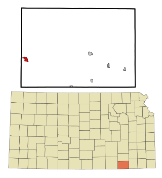
<span class="mw-page-title-main">St. John, Kansas</span> City in Stafford County, Kansas

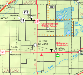
St. John is a city in and the county seat of Stafford County, Kansas, United States. As of the 2020 census, the population of the city was 1,228.

References

  1. 1 2 3 4 U.S. Geological Survey Geographic Names Information System: Denison, Kansas
  2. "2019 U.S. Gazetteer Files". United States Census Bureau. Retrieved July 24, 2020.
  3. 1 2 "Profile of Denison, Kansas in 2020". United States Census Bureau. Archived from the original on June 9, 2022. Retrieved June 8, 2022.
  4. "US Gazetteer files 2010". United States Census Bureau. Archived from the original on January 25, 2012. Retrieved July 6, 2012.
  5. "US Census Bureau, Table P16: HOUSEHOLD TYPE". data.census.gov. Retrieved January 2, 2024.
  6. 1 2 3 4 5 "US Census Bureau, Table DP1: PROFILE OF GENERAL POPULATION AND HOUSING CHARACTERISTICS". data.census.gov. Retrieved January 2, 2024.
  7. Bureau, US Census. "Gazetteer Files". Census.gov. Retrieved December 30, 2023.
  8. "US Census Bureau, Table P1: RACE". data.census.gov. Retrieved January 2, 2024.
  9. "US Census Bureau, Table P2: HISPANIC OR LATINO, AND NOT HISPANIC OR LATINO BY RACE". data.census.gov. Retrieved January 2, 2024.
  10. "US Census Bureau, Table S1101: HOUSEHOLDS AND FAMILIES". data.census.gov. Retrieved January 2, 2024.
  11. "US Census Bureau, Table S1501: EDUCATIONAL ATTAINMENT". data.census.gov. Retrieved January 2, 2024.
  12. "US Census Bureau, Table S1903: MEDIAN INCOME IN THE PAST 12 MONTHS (IN 2020 INFLATION-ADJUSTED DOLLARS)". data.census.gov. Retrieved January 2, 2024.
  13. "US Census Bureau, Table S2001: EARNINGS IN THE PAST 12 MONTHS (IN 2020 INFLATION-ADJUSTED DOLLARS)". data.census.gov. Retrieved January 2, 2024.
  14. "US Census Bureau, Table S1701: POVERTY STATUS IN THE PAST 12 MONTHS". data.census.gov. Retrieved January 2, 2024.
  15. "US Census Bureau, Table S1702: POVERTY STATUS IN THE PAST 12 MONTHS OF FAMILIES". data.census.gov. Retrieved January 2, 2024.
  16. "U.S. Census website". United States Census Bureau . Retrieved July 6, 2012.
  17. "U.S. Census website". United States Census Bureau . Retrieved January 31, 2008.

Further reading