
Shawnee County is located in northeast Kansas, in the central United States. As of the 2020 census, the population was 178,909, making it the third-most populous county in Kansas. Its most populous city, Topeka, is the state capital and county seat. The county was one of the original 33 counties created by the first territorial legislature in 1855, and it was named for the Shawnee tribe of Native Americans.

Pottawatomie County is a county located in the U.S. state of Kansas. As of the 2020 census, the county population was 25,348. The county seat is Westmoreland. The county takes its name from the Potawatomi tribe of Native Americans.

Nemaha County is a county located in the northeastern part of the U.S. state of Kansas. As of the 2020 census, the county population was 10,273. The county seat is Seneca.
Marshall County is a county located in the U.S. state of Kansas. As of the 2020 census, the county population was 10,038. The largest city and county seat is Marysville.

Jackson County is a county in the U.S. state of Kansas. As of the 2020 census, the county population was 13,232. Its county seat and most populous city is Holton. The county, first named Calhoun County for pro-slavery South Carolina Senator John C. Calhoun, was renamed in 1859 for President Andrew Jackson. The Prairie Band Potawatomi Indian Reservation, near the center of the county, comprises about 18.5% of the county's area.

Kansas's 1st congressional district is a congressional district in the U.S. state of Kansas. Commonly known as "The Big First", the district encompasses all or part of 64 counties spanning more than half of the state, making it the seventh-largest district in the nation that does not cover an entire state.

Adrian Township is a township in Jackson County, Kansas, United States. As of the 2000 census, its population was 150.

Banner Township is a township in Jackson County, Kansas, USA. As of the 2000 census, its population was 300. The southernmost part of the township is located within the Prairie Band Potawatomi Indian Reservation.

Douglas Township is a township in Jackson County, Kansas, USA. As of the 2000 census, its population was 2,135.

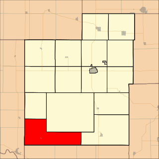
Grant Township is a township in Jackson County, Kansas, USA. As of the 2000 census, its population was 212. The southeasternmost part of the township is located within the Prairie Band Potawatomi Indian Reservation.

Jefferson Township is a township in Jackson County, Kansas, USA. As of the 2000 census, its population was 494.

Liberty Township is a township in Jackson County, Kansas, USA. As of the 2000 census, its population was 513.

Lincoln Township is a township in Jackson County, Kansas, USA. As of the 2000 census, its population was 1,046. The township is located entirely within the Prairie Band Potawatomi Indian Reservation.

Netawaka Township is a township in Jackson County, Kansas, USA. As of the 2000 census, its population was 361.
Washington Township is a township in Jackson County, Kansas, USA. As of the 2000 census, its population was 516.

Rock Creek Township is a township in Jefferson County, Kansas, USA. As of the 2000 census, its population was 2,718.

Richland Township is a township in Jewell County, Kansas, United States. As of the 2000 census, its population was 36.

Sinclair Township is a township in Jewell County, Kansas, USA. As of the 2000 census, its population was 67.

Prairie Township is a township in Davis County, Iowa, USA. As of the 2000 census, its population was 394.

K-62 is an approximately 13.3-mile-long (21.4 km) state highway in the U.S. state of Kansas. It is a north-south highway that serves towns in the northeastern part of the state. It parallels Soldier Creek for its entire length. K-62's southern terminus is at K-16 west of Holton and the northern terminus is at K-9 southwest of Goff.

