
Armagh is the county town of County Armagh and a city in Northern Ireland, as well as a civil parish. It is the ecclesiastical capital of Ireland – the seat of the Archbishops of Armagh, the Primates of All Ireland for both the Roman Catholic Church and the Church of Ireland. In ancient times, nearby Navan Fort was a pagan ceremonial site and one of the great royal capitals of Gaelic Ireland. Today, Armagh is home to two cathedrals and the Armagh Observatory, and is known for its Georgian architecture.

Keady is a village and civil parish in County Armagh, Northern Ireland. It is south of Armagh and near the border with the Republic of Ireland. It is situated mainly in the historic barony of Armagh with six townlands in the barony of Tiranny. It had a population of 3,036 people in the 2011 Census.

Loughgall is a small village, townland and civil parish in County Armagh, Northern Ireland. It is in the historic baronies of Armagh and Oneilland West. It had a population of 282 people in the 2011 Census.
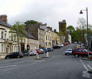
Richhill or Rich Hill is a large village and townland in County Armagh, Northern Ireland. It lies between Armagh and Portadown. It had a population of 2,821 people in the 2011 Census.

Tynan is a village, townland and civil parish in County Armagh, Northern Ireland. It is situated largely in the historic barony of Tiranny, with some areas in the barony of Armagh. It had a population of 71 people in the 2011 Census.

Acton is a hamlet and townland of 22 acres in County Armagh, Northern Ireland, about a half mile north of Poyntzpass. It is situated in the civil parish of Ballymore and the historic barony of Orior Lower and within the Armagh City, Banbridge and Craigavon Borough Council area. It had a population of 72 people in the 2011 Census.
Annahugh is a small village and townland near Loughgall in County Armagh, Northern Ireland. While most of the settlement is within the townland of Annahugh, part of it extends into the neighbouring townland of Ballyhagan. Hence, the two names are sometimes used to refer to the same settlement. It is situated within the Armagh City and District Council area. It had a population of 275 people in the 2011 Census.
Ardress is a hamlet and townland between Loughgall and Annaghmore in County Armagh, Northern Ireland. It is made up of Ardress East and Ardress West. It is within the civil parish of Loughgall and barony of Oneilland West. It had a population of 90 people in the 2011 Census.
Broomhill is a small village in County Armagh, Northern Ireland. It is within the townland of Drumnahunshin and the Armagh City and District Council area. It had a population of 197 people in the 2011 Census.
Edenaveys is a small village and townland in County Armagh, Northern Ireland. It lies southeast of Armagh and is within the Armagh City and District Council area. Historically, it has been anglicized as Edenafeagh amongst other variations. It had a population of 190 people in the 2011 Census.
Lisnadill is a hamlet, townland and civil parish in County Armagh, Northern Ireland. In the 2001 Census it had a population of 54 people. It lies about 3 miles south of Armagh and is within the Armagh City and District Council area.

Loughgilly is a small village, townland and civil parish in County Armagh, Northern Ireland. It is on the main Armagh to Newry road, about halfway between the two. It is within the Armagh City and District Council area. It had a population of 84 people in the 2011 Census.
Derrynoose is a village and civil parish in south County Armagh, Northern Ireland, 4.5 km south-west of Keady.

Killyman is a small village and a civil parish in Northern Ireland, situated on the eastern boundary of County Tyrone and extending into County Armagh. The majority of townlands are in the historic barony of Dungannon Middle in County Tyrone, the rest being in the barony of Oneilland West in County Armagh.

Granemore is a townland of 785 acres in County Armagh, Northern Ireland, about seven miles from Armagh and three miles from Keady. It is situated in the civil parish of Keady and historic barony of Armagh.

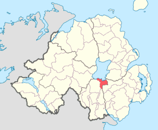
Armagh is a barony in County Armagh, Northern Ireland. It lies in the west of the county, bordering County Tyrone with its north-western boundary, and bordering the Republic of Ireland with its southern boundary. It is bordered by five other baronies in Northern Ireland: Tiranny to the west, Dungannon Middle to the north-west, Oneilland West to the north-east, Fews Lower to the east, and Fews Upper to the south-east. It also borders to the south the barony of Cremorne in the Republic of Ireland.

Oneilland West is a barony in County Armagh, Northern Ireland. It is also called Clancann, after the Mac Cana clan. It lies in the north of the county on the south-western shore of Lough Neagh and the border of County Tyrone. Oneilland West is bordered by five other baronies: Armagh to the west; Dungannon Middle to the north-west; Oneilland East to the north-east; Orior Lower to the south-east; and Kinelarty to the south.
Oneilland East is a barony in the north-east of County Armagh, Northern Ireland. It is also called Clanbrasil. It lies in the north-east corner of the county, on the south-eastern shore of Lough Neagh and the boundary with County Down. Oneilland East is bordered by three other baronies: Oneilland West to the west; Iveagh Lower to the east; and Orior Lower to the south.

Annaghmore is a small village and townland near Loughgall in County Armagh, Northern Ireland. It is situated in the civil parish of Loughgall and the historic barony of Oneilland West. It is within the Armagh City and District Council area. It had a population of 265 people in the 2011 Census.

