
Greencastle is a hamlet in County Tyrone, Northern Ireland. It is within the townland of Sheskinshule.

Aghagallon is a small village and civil parish in County Antrim, Northern Ireland. It is about three miles northeast of Lurgan and had a population of 824 in the 2001 Census.

Blackwatertown is a small village in County Armagh, Northern Ireland. It sits on the River Blackwater, in the townland of Lisbofin, at the border with County Tyrone. The village is around 8 kilometres (5 mi) north of Armagh city, and the villages of Benburb and Moy are nearby. Blackwatertown had a population of 376 in the 2011 Census. The River Blackwater enters Lough Neagh west of Derrywarragh Island and is navigable from Maghery to Blackwatertown.
Moneyslane is a small village and townland in County Down, Northern Ireland, on the main route from Castlewellan to Banbridge. In the 2001 Census, Moneyslane had a population of 147.
Derrytrasna is a small village and townland in County Armagh, Northern Ireland. The village is on a plateau surrounded mainly by bogland in the north of the county. It lies between Lough Neagh, Lough Gullion and the River Bann. In the 2001 Census it had a population of 249 people. Derrytrasna is within the Armagh City, Banbridge and Craigavon Borough Council area.
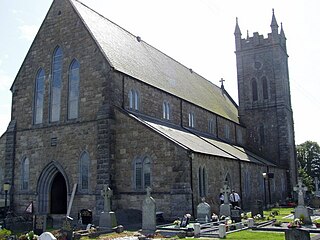
Broomhill is a small village in County Armagh, Northern Ireland. It is within the townland of Drumnahunshin and the Armagh City and District Council area. It had a population of 197 people in the 2011 Census.

Cladymore or Clady More is a small village and townland in County Armagh, Northern Ireland. It is within the Armagh City and District Council area. It had a population of 139 people in the 2011 Census.
Edenaveys is a small village and townland in County Armagh, Northern Ireland. It lies southeast of Armagh and is within the Armagh City and District Council area. Historically, it has been anglicized as Edenafeagh amongst other variations. It had a population of 190 people in the 2011 Census.

Lisnadill is a hamlet, townland and civil parish in County Armagh, Northern Ireland. In the 2001 Census it had a population of 54 people. It lies about 3 miles south of Armagh and is within the Armagh City and District Council area.

Loughgilly is a small village, townland and civil parish in County Armagh, Northern Ireland. It is on the main Armagh to Newry road, about halfway between the two. It is within the Armagh City and District Council area. It had a population of 84 people in the 2011 Census.
Mullaghbrack, Mullabrack or Mullaghbrac is a small village, townland and civil parish in County Armagh, Northern Ireland. It is on the road between Markethill and Hamiltonsbawn, just north of Gosford Forest Park. It had a population of 54 people in the 2011 Census.
Dromintee or Drumintee is a small village and townland in County Armagh, Northern Ireland. In the 2001 Census it had a population of 364 people. It lies within the Newry and Mourne District Council area. It sits within the Ring of Gullion AONB.

Lislea is a small village and townland near Slieve Gullion in County Armagh, Northern Ireland. It is within the civil parish of Killevy and the historic barony of Orior Upper. Today it is within the Newry, Mourne and Down District Council area. It borders the townlands of Ballard, Carricnagalliagh, Aghmakane, Duburren and Drumilly. In the 2001 Census it had a population of 84 people.

Mullaghglass is a small village and townland north of Newry in County Armagh, Northern Ireland. It was named after the nearby townland of Mullaghglass, although the village itself is within the townland of Latt. In the 2001 Census it had a population of 135. It is within the Newry and Mourne District Council area.
Dorsey or Dorsy is a small village and townland between Belleeks and Cullyhanna in County Armagh, Northern Ireland. It has an estimated population of 130-160 people and includes about 30-35 houses.

Mullaghbawn, or Mullaghbane, is a small village and townland near Slieve Gullion in County Armagh, Northern Ireland. In the 2011 Census it had a population of 596.
Derrymore is a small village and townland in County Antrim, Northern Ireland. In the 2001 Census it had a population of 243 people. It lies on the shores of Lough Neagh, within the Armagh City, Banbridge and Craigavon Borough Council area.
Killeen or Killean is a small village and townland in the civil parish of Killeavy, County Armagh, Northern Ireland. It lies about four miles (6.5 km) south of Newry, near the border with County Louth in the Republic of Ireland.

Madden Raparees Gaelic Athletic Club is a Gaelic Athletic Association club from the townland of Madden, southern County Armagh, Northern Ireland. The club is part of Armagh GAA and plays Gaelic football in the Armagh Senior Championship. They play at Raparee Park.

Annaghmore is a small village and townland near Loughgall in County Armagh, Northern Ireland. It is situated in the civil parish of Loughgall and the historic barony of Oneilland West. It had a population of 265 people in the 2011 Census.

