Richmond is a city in the coastal Lower Mainland region of British Columbia, Canada. Mainly a suburban city, it occupies almost the entirety of Lulu Island, between the two estuarine distributaries of the Fraser River. Encompassing the adjacent Sea Island and several other smaller islands and uninhabited islets to its north and south, the suburb neighbours Vancouver and Burnaby on the Burrard Peninsula to the north, New Westminster and Annacis Island to the east, Delta to the south, and the Strait of Georgia to the west.

Vancouver International Airport is an international airport located on Sea Island in Richmond, British Columbia, serving the city of Vancouver and the Lower Mainland region. It is located 12 km (7.5 mi) from Downtown Vancouver. YVR is the second busiest airport in Canada by passenger traffic, behind Toronto Pearson International Airport in Ontario. As a trans-Pacific hub, the airport has more direct flights to China than any other airport in North America or Europe. It is a hub for Air Canada and WestJet. Vancouver International Airport is one of eight Canadian airports that have US Border Pre-clearance facilities. It is also one of the few major international airports to have a terminal for scheduled float planes.

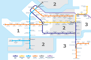
The Canada Line is a rapid transit line in Greater Vancouver, British Columbia, Canada, that is part of the SkyTrain system. The line is owned by TransLink and InTransitBC and is operated by ProTrans BC. Coloured turquoise on route maps, it operates as an airport rail link between Vancouver, Richmond, and the Vancouver International Airport (YVR). The line comprises 16 stations and 19.2 kilometres (11.9 mi) of track; the main line runs from Vancouver to Richmond while a 4-kilometre (2.5 mi) spur line from Bridgeport station connects to the airport. It opened on August 17, 2009, ahead of the 2010 Winter Olympics.
The settlement of Steveston, founded in the 1880s, is a neighbourhood of Richmond in Metro Vancouver. On the southwest tip of Lulu Island, the village is a historic port and salmon canning centre at the mouth of the South Arm of the Fraser River. The early 1900s style architecture attracts both the film and tourism industries.

Arthur Laing was a Canadian politician from British Columbia. Though actively involved with the BC Liberals, his primary achievements were federally as a Liberal Member of Parliament. He served in the cabinets of prime ministers Lester B. Pearson and Pierre Trudeau.

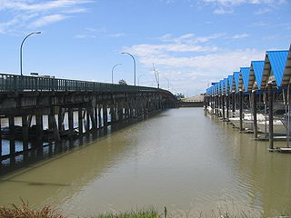
The Arthur Laing Bridge is a crossing over the north arm of the Fraser River, and several minor roads, in Metro Vancouver.

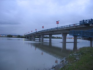
The Knight Street Bridge is a crossing over the north arm of the Fraser River, the Canadian National Railway (CNR) line, and several roads, in Metro Vancouver.

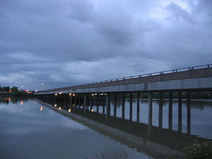
The Oak Street Bridge is a crossing over the north arm of the Fraser River, the Canada Line, and several roads, in Metro Vancouver.
The Moray Bridge, also known as the Moray Channel Bridge, and formerly the Middle Arm Bridge, is a crossing over the middle arm of the Fraser River in Metro Vancouver. Richard Moody, who would name geographical features, such as this channel, after acquaintances, honoured Jonathan Moray (1824–84), a sergeant in the Corps of Royal Engineers, and later the New Westminster police chief.

The Sea Island Connector, is a crossing over the middle arm of the Fraser River in Metro Vancouver.

Airport station was a TransLink public transit exchange on Sea Island, Richmond, in Metro Vancouver. Most bus operations using the location ceased September 7, 2009, two and a half weeks after the opening of the Canada Line, when the exchange downgraded to a regular bus stop.

Sea Island is an island in the Fraser River estuary in the city of Richmond, British Columbia, Canada. It is located south of the city of Vancouver and northwest of Lulu Island.
Transportation in Vancouver, British Columbia, has many of the features of modern cities worldwide. Unlike many large metropolises, Vancouver has no freeways into or through the downtown area. A proposed freeway through the downtown was rejected in the 1960s by a coalition of citizens, community leaders and planners. This event "signalled the emergence of a new concept of the urban landscape" and has been a consistent element of the city's planning ever since.
The No. 2 Road Bridge is a crossing over the middle arm of the Fraser River, and River Rd., in Metro Vancouver.

The Marpole CP Rail Bridge was a partially dismantled crossing over the north arm of the Fraser River, and River Dr., in Metro Vancouver.

Grant McConachie Way is a three-to-six lane arterial route and thoroughfare in Richmond and Vancouver, British Columbia, Canada. Named for aviator Grant McConachie, it is the primary access road into Vancouver International Airport on Sea Island. It is also one of the three roads entering Vancouver from the south, along with Knight Street and Oak Street. Upon entering Vancouver, the road becomes Southwest Marine Drive.
McArthurGlen Designer Outlet Vancouver Airport is an outlet mall on Sea Island in Richmond, British Columbia. It is located in close proximity to Vancouver International Airport. It currently has around 80 retailers over 340,000 square feet.
The Vancouver Greenway Network is a collection of greenways across Vancouver, British Columbia, Canada. Greenways are streets where pedestrians and cyclists are prioritized over motorized vehicles, through structures such as road closures and road diverters to prevent or limit motor vehicle traffic, widened sidewalk-promenades, narrowed road space, speed restrictions, bike lanes, raised sidewalks and speed bumps. The City of Vancouver hopes to create and maintain the trend of constructing new greenways to establish a network where, potentially, every citizen could access a city greenway within a 25-minute walking or a 10-minute cycling distance of their home.
The Marpole Bridge (1889–1957), a.k.a. Eburne Bridge, North Arm Bridge, Sea Island Bridge, or Middle Arm Bridge, was consecutive crossings over the north and middle arms of the Fraser River in Metro Vancouver.
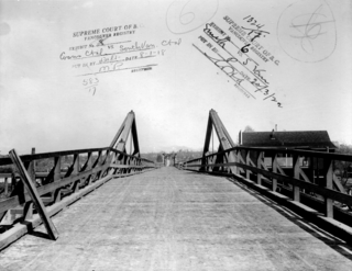
The Fraser St. Bridge (1894–1974), also known as the Fraser Ave. Bridge, North Arm Bridge, No. 5 Rd. Bridge, or Twigg Island Bridge, was a crossing over the north arm of the Fraser River in Metro Vancouver.