
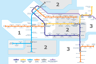
SkyTrain is the medium-capacity rapid transit system serving the Metro Vancouver region in British Columbia, Canada. SkyTrain has 79.6 km (49.5 mi) of track and uses fully automated trains on grade-separated tracks running on underground and elevated guideways, allowing SkyTrain to hold consistently high on-time reliability. In 2022, the system had a ridership of 116,569,000, or about 403,000 per weekday as of the first quarter of 2023.

The Fairmont Hotel Vancouver, formerly and still informally called the Hotel Vancouver, is a historic hotel in Vancouver, British Columbia. Located along West Georgia Street the hotel is situated within the city's Financial District, in Downtown Vancouver. The hotel was designed by two architects, John Smith Archibald, and John Schofield. The hotel is currently managed by Fairmont Hotels and Resorts.

The Expo Line is the oldest line of the SkyTrain rapid transit system in the Metro Vancouver region of British Columbia, Canada. The line is owned and operated by BC Rapid Transit Company, a subsidiary of TransLink, and links the cities of Vancouver, Burnaby, New Westminster and Surrey.

The Millennium Line is the second line of the SkyTrain rapid transit system in the Metro Vancouver region of British Columbia, Canada. The line is owned and operated by BC Rapid Transit Company, a subsidiary of TransLink, and links the cities of Vancouver, Burnaby, Coquitlam and Port Moody. The line was opened in 2002 and was named in recognition of the new millennium.

The Canada Line is a rapid transit line in Greater Vancouver, British Columbia, Canada, that is part of the SkyTrain system. The line is owned by TransLink and InTransitBC and is operated by ProTrans BC. Coloured turquoise on route maps, it operates as an airport rail link between Vancouver, Richmond, and the Vancouver International Airport (YVR). The line comprises 16 stations and 19.2 kilometres (11.9 mi) of track; the main line runs from Vancouver to Richmond while a 4-kilometre (2.5 mi) spur line from Bridgeport station connects to the airport. It opened on August 17, 2009, ahead of the 2010 Winter Olympics.

Waterfront station is a major intermodal public transportation facility and the main transit terminus in Vancouver, British Columbia, Canada. It is located on West Cordova Street in Downtown Vancouver, between Granville and Seymour Street. The station is also accessible via two other street-level entrances, one on Howe Street to the west for direct access to the Expo Line and another on Granville Street to the south for direct access to the Canada Line.

False Creek is a short narrow inlet in the heart of Vancouver, separating the Downtown and West End neighbourhoods from the rest of the city. It is one of the four main bodies of water bordering Vancouver, along with English Bay, Burrard Inlet, and the Fraser River. Granville Island is located within the inlet.
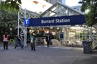
Burrard is an underground station on the Expo Line of Metro Vancouver's SkyTrain rapid transit system. The station is located in Downtown Vancouver on Burrard Street, where Melville and Dunsmuir Streets meet, and is the western terminus of the R5 Hastings St that provides service to Simon Fraser University.

Granville is an underground station on the Expo Line of Metro Vancouver's SkyTrain rapid transit system. The station is located in Downtown Vancouver on the portion of Granville Street that is known as the Granville Mall. The station is accessible from the surface via entrances on Granville Street and Seymour Street, and the Dunsmuir entrance between Granville and Seymour.

Stadium–Chinatown is an elevated station on the Expo Line of Metro Vancouver's SkyTrain rapid transit system. The station is located in Vancouver, British Columbia, Canada, at the eastern entrance of the Dunsmuir Tunnel. It is one of four stations on the Expo Line that serve Downtown Vancouver.

Main Street–Science World is an elevated station on the Expo Line of Metro Vancouver's SkyTrain rapid transit system in Vancouver, British Columbia, Canada. The station is accessible from both sides of Main Street at the intersection of Main Street and Terminal Avenue and is adjacent to Pacific Central Station, the city's inter-city railway and bus terminal.
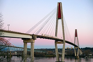
The SkyBridge is a cable-stayed railway bridge in Metro Vancouver, British Columbia, Canada. Built between 1987 and 1989, it carries trains of the Expo Line of TransLink's SkyTrain across the Fraser River between New Westminster and Surrey. The SkyBridge opened for revenue use on March 16, 1990, with the second half of the Phase II extension of SkyTrain to Scott Road station.
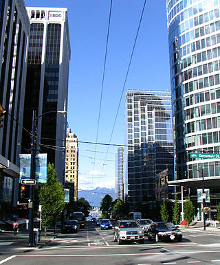
Burrard Street is a major thoroughfare in Vancouver, British Columbia, Canada. It is the central street of Downtown Vancouver and the Financial District. The street is named for Burrard Inlet, located at its northern terminus, which in turn is named for Sir Harry Burrard-Neale.

The Cambie Bridge is a six-lane, precast, box girder bridge spanning False Creek in Vancouver, British Columbia. The current bridge opened in 1985, but is the third bridge at the same location. Often referred to as the Cambie Street Bridge, it connects Cambie Street on the south shore of False Creek to both Nelson and Smithe Streets in the downtown peninsula. It is the easternmost of False Creek's fixed crossings; the Burrard and Granville bridges are a little more than a kilometre to the west, and the new Canada Line SkyTrain tunnel is built just west of the Cambie Bridge.

The 98 B-Line was a bus rapid transit line in Metro Vancouver, British Columbia, Canada. It linked Richmond to Downtown Vancouver, with a connection to Vancouver International Airport. It travelled mainly along Granville Street in Vancouver and a dedicated bus lane on No. 3 Road in Richmond. It was operated by Coast Mountain Bus Company and was funded by TransLink. The route was 16 kilometres (9.9 mi) long. The line carried over 18,000 passengers daily. It was discontinued on September 7, 2009, two and a half weeks after the opening of the Canada Line, which replaced it.

Downtown Vancouver is the central business district and the city centre neighbourhood of Vancouver, Canada, on the northwestern shore of the Burrard Peninsula in the Lower Mainland region of British Columbia. It occupies most of the north shore of the False Creek inlet, which cuts into the Burrard Peninsula creating the Downtown Peninsula, where the West End neighbourhood and Stanley Park are also located.
Transportation in Vancouver, British Columbia, has many of the features of modern cities worldwide. Unlike many large metropolises, Vancouver has no freeways into or through the downtown area. A proposed freeway through the downtown was rejected in the 1960s by a coalition of citizens, community leaders and planners. This event "signalled the emergence of a new concept of the urban landscape" and has been a consistent element of the city's planning ever since.

Olympic Village is an underground station on the Canada Line of Metro Vancouver's SkyTrain rapid transit system. The station is located at the intersection of Cambie Street and West 2nd Avenue, adjacent to the Cambie Street Bridge in Vancouver, British Columbia, Canada.

The Financial District is a highrise office commercial area within the central business district of Vancouver, British Columbia, Canada. Located roughly along Burrard and West Georgia Streets on the Downtown Peninsula, the Financial District contains more than 60% of Greater Vancouver's office space, and is home to headquarters of forest products and mining companies. The area contains numerous federal and non-governmental organizations (NGO) offices, overseas missions and consulates, and headquarter and branch offices of national and international banks and financial services, accounting and law firms, and luxury hotels.

Commercial–Broadway is a rapid transit station complex in Metro Vancouver's SkyTrain system in Vancouver, British Columbia, Canada. It serves an elevated portion of the Expo Line and a below-grade portion of the Millennium Line. It is a major transit hub, with the third-highest number of boardings of any SkyTrain station, and a terminus of the region's busiest bus route, the 99 B-Line.

