Waterfront station (Vancouver)

Last updated

Waterfront
TransLink station
Vancouver Waterfront Station.jpg
General information
Location
  • 601 West Cordova Street, Vancouver
  • 439 Granville Street, Vancouver
Coordinates 49°17′09″N123°06′42″W / 49.28583°N 123.11167°W / 49.28583; -123.11167
Owned by
Operated by TransLink
Platforms3 separate sets of centre platforms
Tracks6
Connections Translinkbusrapid.svg R5 Hastings St
Construction
Structure typeAt-grade and underground
Bicycle facilitiesOutside bike racks
AccessibleYes
ArchitectBarott, Blackader and Webster
Other information
Station codeWF
Fare zone1
History
OpenedAugust 1, 1914;109 years ago (1914-08-01)
Key dates
1977 SeaBus opens
1985SkyTrain: Expo Line opens
1995 West Coast Express opens
2002SkyTrain: Millennium Line opens
2009SkyTrain: Canada Line opens
2016SkyTrain: Millennium Line rerouted
Passengers
2023 [1]
  • 9,889,900 (Expo and Canada Lines) 25.3% Increase2.svg
  • 614,000 (West Coast Express) 49.0% Increase2.svg
Rank
  • 1 of 53 (Expo and Canada Lines)
  • 1 of 8 (West Coast Express)
Services
Preceding station TransLink Following station
Terminus Expo Line Burrard
Canada Line Vancouver City Centre
SeaBus Lonsdale Quay
Terminus
West Coast Express Moody Centre
towards Mission City
Former services
Preceding station Canadian Pacific Railway Following station
TerminusMain Line Heatley Avenue
Preceding station TransLink Following station
Terminus Millennium Line Burrard
towards VCC–Clark via Columbia

Waterfront station is a major intermodal public transportation facility and the main transit terminus in Vancouver, British Columbia, Canada. It is on West Cordova Street in Downtown Vancouver, between Granville and Seymour Street. The station is also accessible via two other street-level entrances, one on Howe Street to the west for direct access to the Expo Line and another on Granville Street to the south for direct access to the Canada Line.

Contents

The station is within walking distance of Vancouver's historical Gastown district, Canada Place, Vancouver Convention Centre, Harbour Centre, Sinclair Centre, and the Vancouver Harbour Flight Centre float plane terminal. A heliport operated by Helijet, along with the downtown campuses for Simon Fraser University and the British Columbia Institute of Technology, are also located within the vicinity of the station.

History

Waterfront station c. 1923 Waterfront Station Vancouver 1923.jpg
Waterfront station c.1923

Waterfront station was built by the Canadian Pacific Railway (CPR) and opened on August 1, 1914. [2] It was the Pacific terminus for the CPR's transcontinental passenger trains to Montreal, Quebec, and Toronto, Ontario. The current station is the third CPR station. The previous CPR station was located one block west, at the foot of Granville and, unlike the current classical-styled Waterfront station, was built in "railway gothic" like the CPR's many railway hotels. [3] [4]

In 1978, when Via Rail took over the passenger operations of the CPR and the Canadian National Railway, it continued using both railways' stations in Vancouver, but a year later, Via consolidated its Vancouver operations at Pacific Central Station, the CN station near False Creek, and ceased using the CPR station. The last scheduled Via passenger train to use Waterfront station departed on October 27, 1979. [2]

Waterfront station's transformation into a public intermodal transit facility began in 1977.[ citation needed ] That year, the SeaBus began operating out of a purpose-built floating pier that was connected to the main terminal building via an overhead walkway above the CPR tracks. The CPR's passenger platform and some of its tracks were torn up in the early 1980s to make way for the guideway of the original SkyTrain line (Expo Line), which opened on December 11, 1985. During Expo 86, SkyTrain operated special shuttle trains between Waterfront station and Stadium–Chinatown station (then named Stadium station), connecting the Canadian Pavilion at Canada Place to the main Expo site along False Creek.[ citation needed ]

A private ferry company, Royal SeaLink Express, ran passenger ferries from a new dock on the west side of the SeaBus terminal to Victoria and Nanaimo in the early 1990s, but ultimately folded.[ citation needed ] In 2003, HarbourLynx began operating out of Royal Sealink's old facility at the SeaBus terminal. In 2006, following major engine problems with their only vessel, they folded as well.

In 1995, platforms were built adjacent to the SkyTrain station for the West Coast Express, which uses the existing CPKC tracks. The platforms for the West Coast Express were built in the same location as the old CPR platforms.

In 2002, Millennium Line trains began to share tracks with the Expo Line at Waterfront station. The lines continued to share tracks until late 2016, when an Expo Line branch to Production Way–University station was created in replacement of the Millennium Line service between VCC–Clark and Waterfront stations. [5]

In 2009, the Canada Line opened with separate platforms which are accessible via the main station building, but require leaving the fare-paid zone when transferring between other modes. Waterfront station serves as a common terminus point for both the Expo Line and the Canada Line.

Waterfront station was one of the first stations to receive TransLink's "T" signage, denoting a transit station. [6] This signage was originally installed in the downtown core of Vancouver to help visitors during the 2010 Olympics.

In 2018, TransLink announced that Waterfront's Canada Line platforms, as well as two other stations on the line within downtown Vancouver, would receive an accessibility upgrade including additional escalators, as most Canada Line stations were built with only up-escalators initially. [7] Construction began in early 2019 and was completed in December. [8] [9]

In 2020, TransLink started work on replacing the escalators connecting to the Expo Line. [10] The first step in this project was to close access to the Expo Line from Cordova Street for three weeks in June. The closure forced passengers to access the Expo Line from the Howe Street entrance. Because the construction blocked access to the elevators to the Expo Line platforms, a temporary shuttle bus service between the SeaBus terminal, the main concourse area, and Burrard station was instated.

In 2022, TransLink relocated the in-person service centre at Stadium–Chinatown station and opened a new 580-square-metre (6,200 sq ft) customer service centre at Waterfront station on September 23. [11] [12]

Architecture

Waterfront station Waterfront Station 201807.jpg
Waterfront station
Waterfront's main concourse Waterfront Station Concourse 201807.jpg
Waterfront's main concourse
Waterfront station, Vancouver Waterfront station Vancouver (42914420220).jpg
Waterfront station, Vancouver

Waterfront's main station building was designed in a neoclassical style, with a symmetrical red-brick facade dominated by a row of smooth, white Ionic order columns. The Ionic columns are repeated in the grand interior hall, flanking the perimeter of the space. The main hall features two large clocks facing each other high on the east and west walls. Paintings depicting various scenic Canadian landscapes, completed in 1916 by Adelaide Langford, line the walls above the columns. The Montreal architecture firm Barott, Blackader and Webster was responsible for designing the main station building. [13]

The station building is owned by Cadillac Fairview and underwent renovations in 2015 to restore its brick facade. [14]

Services

Station information

The Howe Street entrance to Waterfront station, serving SkyTrain's Expo Line Waterfront stn skytrain enterance.jpg
The Howe Street entrance to Waterfront station, serving SkyTrain's Expo Line
Expo Line platform (Platforms 1 & 2) Expo Line platform of Waterfront station.jpg
Expo Line platform (Platforms 1 & 2)
The digital "next arrival" sign at the Expo Line island platform Waterfront Station screen-Vancouver.jpg
The digital "next arrival" sign at the Expo Line island platform
SkyTrain's Canada Line platform Vancouver 064.jpg
SkyTrain's Canada Line platform
West Coast Express platform WCE Waterfront.JPG
West Coast Express platform

Station layout

SStreetCordova Street, Howe Street, Granville Street entrances
Concourse
(Cordova)
Main connection points between various modes of transportation
Compass ticketing machines, ATM, shops, fare gates (Expo Line)
CConcourse
(Howe)
Serving Expo Line
Connections to Sinclair Centre and Waterfront Center
Compass ticketing machines, fare gates (Expo Line)
Concourse
(Granville)
Serving Canada Line
Compass ticketing machines, shops, fare gates (Canada Line)
TPlatform 1
  Expo Line termination track
Island platform ; doors will open on the left
Platform 2
Outbound
  Expo Line towards King George and Production Way–University (Burrard)
   West Coast Express towards Mission City (Moody Centre)
Island platform ; doors will open on the left or right
   West Coast Express towards Mission City (Moody Centre)
Lower Concourse
(Cordova)
Compass ticketing machines, fare gates (Canada Line)
Platform 3
Outbound
  Canada Line towards Richmond–Brighouse and YVR–Airport (Vancouver City Centre)
Island platform ; doors will open on the left or right
Platform 4
Outbound
  Canada Line towards Richmond–Brighouse and YVR–Airport (Vancouver City Centre)
Lower Concourse
(SeaBus)
Fare gates(Helipad Exit), washrooms
Connection to HeliJet heliport
 Unused
Island platform ; doors will open on the right
   SeaBus outbound towards Lonsdale Quay (Terminus)
Island platform ; doors will open on the left or right
   SeaBus outbound towards Lonsdale Quay (Terminus)
Island platform ; doors will open on the left
 Unused

Entrances

Transit connections

Bus services load on Cordova Street. Additional stops are on Hastings Street, adjacent to the Canada Line entrance near Granville Street for the R5 RapidBus service. [15]

BayLocationRouteNotes
1Cordova Street
Westbound
44 UBC
  • Express, weekday only. No evening service.
2Cordova Street
Westbound
2 Macdonald
3Cordova Street
Westbound
50 False Creek South
4Cordova Street
Eastbound
3 Main
4 Powell
7 Nanaimo Station
8 Fraser
10 Downtown
50 Waterfront Station
N8 Fraser Nightbus
Hastings Street
Westbound
R5 Hastings Street to Burrard Station
Hastings Street
Eastbound
R5 Hastings Street to SFU
  • RapidBus service

See also

Related Research Articles

<span class="mw-page-title-main">SkyTrain (Vancouver)</span> Automated rapid transit system in Metro Vancouver, Canada

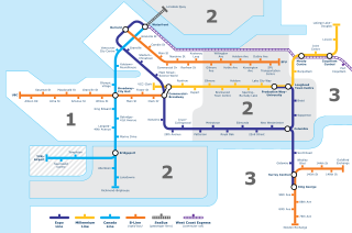
SkyTrain is the medium-capacity rapid transit system serving the Metro Vancouver region in British Columbia, Canada. SkyTrain has 79.6 km (49.5 mi) of track and uses fully automated trains on grade-separated tracks running on underground and elevated guideways, allowing SkyTrain to hold consistently high on-time reliability. In 2023, the system had a ridership of 141,339,300, or about 446,400 per weekday as of the fourth quarter of 2023.

<span class="mw-page-title-main">Expo Line (SkyTrain)</span> Rapid transit line in Metro Vancouver, Canada

The Expo Line is the oldest line of the SkyTrain rapid transit system in the Metro Vancouver region of British Columbia, Canada. The line is owned and operated by BC Rapid Transit Company, a subsidiary of TransLink, and links the cities of Vancouver, Burnaby, New Westminster and Surrey.

<span class="mw-page-title-main">Millennium Line</span> Rapid transit line in Metro Vancouver, Canada

The Millennium Line is the second line of the SkyTrain rapid transit system in the Metro Vancouver region of British Columbia, Canada. The line is owned and operated by BC Rapid Transit Company, a subsidiary of TransLink, and links the cities of Vancouver, Burnaby, Coquitlam and Port Moody. The line was opened in 2002 and was named in recognition of the new millennium.

<span class="mw-page-title-main">Burrard station</span> Metro Vancouver SkyTrain station

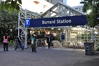
Burrard is an underground station on the Expo Line of Metro Vancouver's SkyTrain rapid transit system. The station is located in Downtown Vancouver on Burrard Street, where Melville and Dunsmuir Streets meet, and is the western terminus of the R5 Hastings St that provides service to Simon Fraser University.

<span class="mw-page-title-main">Granville station (SkyTrain)</span> Metro Vancouver SkyTrain station

Granville is an underground station on the Expo Line of Metro Vancouver's SkyTrain rapid transit system. The station is located in Downtown Vancouver on the portion of Granville Street that is known as the Granville Mall. The station is accessible from the surface via entrances on Granville Street and Seymour Street, and the Dunsmuir entrance between Granville and Seymour.

<span class="mw-page-title-main">Stadium–Chinatown station</span> Metro Vancouver SkyTrain station

Stadium–Chinatown is an elevated station on the Expo Line of Metro Vancouver's SkyTrain rapid transit system. The station is located in Vancouver, British Columbia, Canada, at the eastern entrance of the Dunsmuir Tunnel. It is one of four stations on the Expo Line that serve Downtown Vancouver.

<span class="mw-page-title-main">Main Street–Science World station</span> Metro Vancouver SkyTrain station

Main Street–Science World is an elevated station on the Expo Line of Metro Vancouver's SkyTrain rapid transit system in Vancouver, British Columbia, Canada. The station is accessible from both sides of Main Street at the intersection of Main Street and Terminal Avenue and is adjacent to Pacific Central Station, the city's inter-city railway and bus terminal.

<span class="mw-page-title-main">Metrotown station</span> Metro Vancouver SkyTrain station

Metrotown is an elevated station on the Expo Line of Metro Vancouver's SkyTrain rapid transit system, and is located along Central Boulevard, directly across from the Metropolis at Metrotown shopping centre, in Burnaby, British Columbia, Canada. As of 2022, it is the second-busiest station in the SkyTrain system.

<span class="mw-page-title-main">Columbia station (SkyTrain)</span> Metro Vancouver SkyTrain station

Columbia is an underground station on the Expo Line of Metro Vancouver's SkyTrain rapid transit system. The station is located on Columbia Street in New Westminster, British Columbia, and is a major transfer point between the two branches of the Expo Line, which separate from the main line at the flying junction just east of the station, with one terminating at King George station in Surrey and the other at Production Way–University station in Burnaby.

<span class="mw-page-title-main">Lougheed Town Centre station</span> Metro Vancouver SkyTrain station

Lougheed Town Centre is an elevated station on the Expo and Millennium Lines of Metro Vancouver's SkyTrain rapid transit system. The station is located at Lougheed Highway and Austin Road in Burnaby, British Columbia, Canada. Initially a Millennium Line station, a reorganization of SkyTrain service patterns in 2016 brought a branch of the Expo Line over the existing tracks to serve the station. It is one of three stations where transfer between the Expo Line and the Millennium Line is possible, the other two such points of transfer being Commercial–Broadway and Production Way–University stations.

<span class="mw-page-title-main">Production Way–University station</span> Metro Vancouver SkyTrain station

Production Way–University is an elevated station on the Expo and Millennium Lines of Metro Vancouver's SkyTrain rapid transit system. The station is located at the intersection of Lougheed Highway and Production Way in Burnaby, British Columbia, Canada. Initially a Millennium Line station, a reorganization of SkyTrain service patterns in 2016 made Production Way–University a terminus for a branch of the Expo Line.

<span class="mw-page-title-main">98 B-Line</span> Former express bus service in Metro Vancouver, Canada

The 98 B-Line was a bus rapid transit line in Metro Vancouver, British Columbia, Canada, that began service in September 2000. It linked Richmond to Downtown Vancouver, with a connection to Vancouver International Airport. It travelled mainly along Granville Street in Vancouver and a dedicated bus lane on No. 3 Road in Richmond. It was operated by Coast Mountain Bus Company and was funded by TransLink. The route was 16 kilometres (9.9 mi) long. The line carried over 18,000 passengers daily. It was discontinued in September 2009, shortly after the opening of the Canada Line, which replaced it.

<span class="mw-page-title-main">Downtown Vancouver</span> Neighbourhood of Vancouver in British Columbia, Canada

Downtown Vancouver is the central business district and the city centre neighbourhood of Vancouver, Canada, on the northwestern shore of the Burrard Peninsula in the Lower Mainland region of British Columbia. It occupies most of the north shore of the False Creek inlet, which cuts into the Burrard Peninsula creating the Downtown Peninsula, where the West End neighbourhood and Stanley Park are also located.

<span class="mw-page-title-main">Transportation in Vancouver</span>

Transportation in Vancouver, British Columbia, has many of the features of modern cities worldwide. Unlike many large metropolises, Vancouver has no freeways into or through the downtown area. A proposed freeway through the downtown was rejected in the 1960s by a coalition of citizens, community leaders and planners. This event "signalled the emergence of a new concept of the urban landscape" and has been a consistent element of the city's planning ever since.

<span class="mw-page-title-main">Marine Drive station</span> Metro Vancouver SkyTrain station

Marine Drive is an elevated station on the Canada Line of Metro Vancouver's SkyTrain rapid transit system. The station is located at the intersection of Cambie Street and SW Marine Drive in Vancouver, British Columbia.

<span class="mw-page-title-main">Yaletown–Roundhouse station</span> Metro Vancouver SkyTrain station

Yaletown–Roundhouse is an underground station on the Canada Line of Metro Vancouver's SkyTrain rapid transit system. The station is located on Davie Street at Mainland Street, approximately 80 metres (260 ft) northwest of Pacific Boulevard, and serves the residential and retail areas of Yaletown and Downtown Vancouver in Vancouver, British Columbia, Canada.

<span class="mw-page-title-main">Vancouver City Centre station</span> Metro Vancouver SkyTrain station

Vancouver City Centre is an underground station on the Canada Line of Metro Vancouver's SkyTrain rapid transit system. The station is located on Granville Street, between West Georgia Street and Robson Street in Downtown Vancouver, and serves the shopping and entertainment districts along Granville and Robson streets, and the office and shopping complexes of Pacific Centre and Vancouver Centre.

<span class="mw-page-title-main">R5 Hastings St</span> Express bus service in Metro Vancouver, Canada

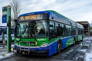
The R5 Hastings St is an express bus service with bus rapid transit elements in Metro Vancouver, Canada. Part of TransLink's RapidBus network, it travels along Hastings Street, a major east–west route, and connects Simon Fraser University to the SkyTrain system's Burrard station on the Expo Line in Downtown Vancouver. It replaced the 95 B-Line route on January 6, 2020.

<span class="mw-page-title-main">Commercial–Broadway station</span> Metro Vancouver SkyTrain station

Commercial–Broadway is a rapid transit station complex in Metro Vancouver's SkyTrain system in Vancouver, British Columbia, Canada. It serves an elevated portion of the Expo Line and a below-grade portion of the Millennium Line. It is a major transit hub, with the third-highest number of boardings of any SkyTrain station, and a terminus of the region's busiest bus route, the 99 B-Line.

References

  1. "2023 Transit Service Performance Review – SkyTrain Stations Summaries". tableau.com. TransLink. April 17, 2024. Archived from the original on April 30, 2024. Retrieved May 1, 2024.
  2. 1 2 "By the Numbers: Waterfront Station turns 100". The Province . July 31, 2014. Retrieved April 3, 2018.
  3. Photograph of CPR Station, foot of Granville, 1906, British Columbia Archives.
  4. CPR station, undated photograph Archived June 7, 2011, at the Wayback Machine , British Columbia Archives, at Columbia Pacific.
  5. "TransLink introduces new SkyTrain operating pattern on October 22". TransLink. September 19, 2016. Archived from the original on March 14, 2020. Retrieved November 5, 2016.
  6. "More T signage is now up in downtown Vancouver", The Buzzer Blog, TransLink, January 27, 2010.
  7. Chan, Kenneth (July 9, 2018). "More escalators to be installed at every Canada Line station in downtown Vancouver". Daily Hive . Retrieved February 10, 2019.
  8. "Canada Line Escalator Enhancement Project". TransLink. Archived from the original on February 9, 2019. Retrieved February 10, 2019.
  9. Chan, Kenneth (February 1, 2019). "Construction begins on new escalators for all downtown Canada Line stations". Daily Hive . Retrieved February 10, 2019.
  10. Chan, Kenneth (June 8, 2020). "Main entrance for Waterfront Station's Expo Line to close for three-week renovation". Daily Hive Vancouver. Retrieved June 30, 2020.
  11. Kertcher, Sarah (September 22, 2022). "TransLink unveils new Customer Service Centre at Waterfront Station". The Buzzer Blog. TransLink. Retrieved September 23, 2022.
  12. Chan, Kenneth (September 22, 2022). "Inside TransLink's new Customer Service Centre at Waterfront Station". Daily Hive. Retrieved September 23, 2022.
  13. "Waterfront Station". Vancouver Historic Building Atlas. Simon Fraser University . Retrieved April 7, 2019.
  14. Lazaruk, Susan (July 12, 2015). "By the Numbers: Waterfront Station gets a major overhaul". The Province. Retrieved June 28, 2023.
  15. Waterfront Station (PDF) (Map). TransLink. January 2022. Retrieved June 6, 2022.

Commons-logo.svg Media related to Waterfront station at Wikimedia Commons