
A trail, also known as a path or track, is an unpaved lane or a small paved road not intended for usage by motorized vehicles, usually passing through a natural area. In the United Kingdom and the Republic of Ireland, a path or footpath is the preferred term for a pedestrian or hiking trail. The term is also applied in North America to accompanying routes along rivers, and sometimes to highways. In the US, the term was historically used for a route into or through wild territory used by explorers and migrants. In the United States, "trace" is a synonym for trail, as in Natchez Trace.

Burnaby is a city in the Lower Mainland region of British Columbia, Canada. Located in the centre of the Burrard Peninsula, it neighbours the City of Vancouver to the west, the District of North Vancouver across the confluence of the Burrard Inlet with its Indian Arm to the north, Port Moody and Coquitlam to the east, New Westminster and Surrey across the Fraser River to the southeast, and Richmond on the Lulu Island to the southwest.

The Trans Canada Trail, officially named The Great Trail between September 2016 and June 2021, is a cross-Canada system of greenways, waterways, and roadways that stretches from the Atlantic to the Pacific to the Arctic oceans. The trail extends over 24,000 km (15,000 mi); it is now the longest recreational, multi-use trail network in the world. The idea for the trail began in 1992, shortly after the Canada 125 celebrations. Since then it has been supported by donations from individuals, corporations, foundations, and all levels of government.
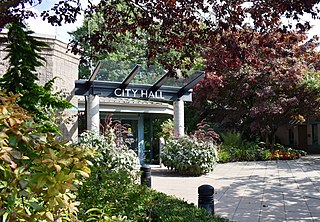
Pitt Meadows is a municipality of Metro Vancouver in southwestern British Columbia, Canada. Incorporated in 1914, it has a land area of 86.34 square kilometres (33.34 sq mi) and a population of 19,146 as of 2021. The municipality received its name from the Pitt River and Pitt Lake. Pitt Meadows is one of 21 municipalities plus Electoral Area A that comprises the Metro Vancouver Regional District.
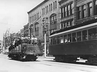
The British Columbia Electric Railway (BCER) was an historic railway which operated in southwestern British Columbia, Canada. Originally the parent company for, and later a division of, BC Electric Company, the BCER assumed control of existing streetcar and interurban lines in southwestern British Columbia in 1897, and operated the electric railway systems in the region until the last interurban service was discontinued in 1958. During and after the streetcar era, BC Electric also ran bus and trolleybus systems in Greater Vancouver and bus service in Greater Victoria; these systems subsequently became part of BC Transit, and the routes in Greater Vancouver eventually came under the control of TransLink. Trolley buses still run in the City of Vancouver with one line extending into Burnaby.
Highway 99A is a series of former highways in the southwestern part of British Columbia, Canada. It was the designation of the former 1942 alignment of Highway 99 as well a various alternate routes which existed in the 1950s and 1960s. The last official use of '99A' was decommissioned in 2006, although some present-day, commercially published road maps still show it and some remnant signage still remains.

The City of Langley, commonly referred to as Langley City, or just Langley, is a municipality in the Metro Vancouver Regional District in British Columbia, Canada. It lies directly east of Surrey, adjacent to the Cloverdale area, and is surrounded elsewhere by the Township of Langley, bordered by its neighbourhoods of Willowbrook to the north, Murrayville to the east, and Brookswood and Fern Ridge to the south.

Metrotown is an elevated station on the Expo Line of Metro Vancouver's SkyTrain rapid transit system, and is located along Central Boulevard, directly across from the Metropolis at Metrotown shopping centre, in Burnaby, British Columbia, Canada. As of 2022, it is the second-busiest station in the SkyTrain system.
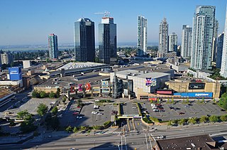
Metropolis at Metrotown is a three-storey shopping mall complex in the Metrotown area of Burnaby, British Columbia, Canada. Opened in 1986, it is the largest mall in British Columbia and the third-largest in Canada, behind Alberta's West Edmonton Mall and Ontario's Square One Shopping Centre, with 27 million customer visits annually. The mall is located adjacent to Metrotown station on the SkyTrain rapid transit system. Three office buildings are part of the complex along Central Boulevard.

A greenway is usually a shared-use path along a strip of undeveloped land, in an urban or rural area, set aside for recreational use or environmental protection. Greenways are frequently created out of disused railways, canal towpaths, utility company rights of way, or derelict industrial land. Greenways can also be linear parks, and can serve as wildlife corridors. The path's surface may be paved and often serves multiple users: walkers, runners, bicyclists, skaters and hikers. A characteristic of greenways, as defined by the European Greenways Association, is "ease of passage": that is that they have "either low or zero gradient", so that they can be used by all "types of users, including mobility impaired people".
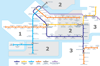
Transportation in Vancouver, British Columbia, has many of the features of modern cities worldwide. Unlike many large metropolises, Vancouver has no freeways into or through the downtown area. A proposed freeway through the downtown was rejected in the 1960s by a coalition of citizens, community leaders and planners. This event "signalled the emergence of a new concept of the urban landscape" and has been a consistent element of the city's planning ever since.

Coquitlam Central station is an intermodal rapid transit station in Metro Vancouver served by both the Millennium Line—part of the SkyTrain system—and the region's West Coast Express commuter rail system. The station is located on the north side of the Canadian Pacific Railway (CPR) tracks in Coquitlam, just west of the Lougheed Highway rail overpass, near the Coquitlam Centre shopping mall. 601 parking spaces are available on site. All services are operated by TransLink.
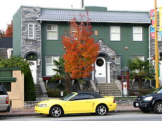
North Burnaby is a general name for a large neighbourhood in the City of Burnaby, British Columbia, that includes a number of smaller ones. It stretches from Boundary Road in the west to Burnaby Mountain with Simon Fraser University in the east and is bounded by Burrard Inlet to the north and the Lougheed Highway to the south. It is a desirable place to live for many local and immigrant families, which is reflected by real-estate prices that keep climbing and have doubled in the last 15 years.

The Kenilworth Trail is a paved bicycle trail in Minneapolis, Minnesota, United States. It runs nearly 1.5 miles (2.4 km) and acts as a connector between the Cedar Lake Trail in the north and the Midtown Greenway in the south. Like the Cedar Lake Trail, most of the route is composed of a triple-divided cycleway/pedway with a pair of one-way paths for bicycles and another path for pedestrians. On some maps, a southern segment of the Kenilworth Trail is called the Burnham Trail. The trail corridor has been considered the most highly trafficked in the Minneapolis park system.
The Vancouver Greenway Network is a collection of greenways across Vancouver, British Columbia, Canada. Greenways are streets where pedestrians and cyclists are prioritized over motorized vehicles, through structures such as road closures and road diverters to prevent or limit motor vehicle traffic, widened sidewalk-promenades, narrowed road space, speed restrictions, bike lanes, raised sidewalks and speed bumps. The City of Vancouver hopes to create and maintain the trend of constructing new greenways to establish a network where, potentially, every citizen could access a city greenway within a 25-minute walking or a 10-minute cycling distance of their home.
Better Environmentally Sound Transportation (BEST) is a Vancouver-based charity focused on promoting walking, cycling, public transit, and other forms of sustainable transportation in Metro Vancouver. The organization was founded in 1991 and has several active projects as of 2019.

Hiawatha LRT Trail is a 4.7-mile (7.6 km), multi-use path adjacent to a light-rail transit line in Minneapolis, Minnesota, United States, that is popular with bicycle commuters. Users travel along the Metro Blue Line and Hiawatha Avenue transit corridor, reaching downtown Minneapolis near an indoor sports stadium at the trail’s northern end, and reaching a bridge above Minnehaha Creek at the trail’s southern end. Hiawatha LRT Trail provides a vital link between several Minneapolis neighborhoods and the city’s downtown area.

The Orange Line Bikeway is a cycle route in Los Angeles County, California, that runs 17.9 miles (28.8 km) and “spans the lengths of the San Fernando Valley’s major communities” from Chatsworth to North Hollywood, “connecting such places as Pierce College, the Sepulveda Basin Recreation Area, the Van Nuys Government Center and Valley College.”


