
Richmond is a city in the coastal Lower Mainland region of British Columbia, Canada. It occupies almost the entirety of Lulu Island, between the two estuarine distributaries of the Fraser River. Encompassing the adjacent Sea Island and several other smaller islands and uninhabited islets to its north and south, it neighbours Vancouver and Burnaby on the Burrard Peninsula to the north, New Westminster and Annacis Island to the east, Delta to the south, and the Strait of Georgia to the west.

Burnaby is a city in the Lower Mainland region of British Columbia, Canada. Located in the centre of the Burrard Peninsula, it neighbours the City of Vancouver to the west, the District of North Vancouver across the confluence of the Burrard Inlet with its Indian Arm to the north, Port Moody and Coquitlam to the east, New Westminster and Surrey across the Fraser River to the southeast, and Richmond on the Lulu Island to the southwest.

New Westminster is a city in the Lower Mainland region of British Columbia, Canada, and a member municipality of the Metro Vancouver Regional District. It was founded by Major-General Richard Moody as the capital of the Colony of British Columbia in 1858 and continued in that role until the Mainland and Island colonies were merged in 1866. It was the British Columbia Mainland's largest city from that year until it was passed in population by Vancouver during the first decade of the 20th century.

The Township of Langley is a district municipality immediately east of the City of Surrey in southwestern British Columbia, Canada. It extends south from the Fraser River to the Canada–United States border, and west of the City of Abbotsford. Langley Township is not to be confused with the City of Langley, which is adjacent to the township but politically is a separate entity. Langley is located in the eastern part of Metro Vancouver.
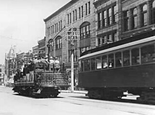
The British Columbia Electric Railway (BCER) was an historic railway which operated in southwestern British Columbia, Canada. Originally the parent company for, and later a division of, BC Electric Company, the BCER assumed control of existing streetcar and interurban lines in southwestern British Columbia in 1897, and operated the electric railway systems in the region until the last interurban service was discontinued in 1958. During and after the streetcar era, BC Electric also ran bus and trolleybus systems in Greater Vancouver and bus service in Greater Victoria; these systems subsequently became part of BC Transit, and the routes in Greater Vancouver eventually came under the control of TransLink. Trolley buses still run in the City of Vancouver with one line extending into Burnaby.
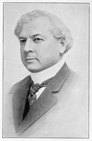
Sir Richard McBride, was a British Columbia politician and is often considered the founder of the British Columbia Conservative Party. McBride was first elected to the provincial legislature in the 1898 election and served in the cabinet of James Dunsmuir from 1900 to 1901. McBride believed that the province's system of non-party government was unstable and hindered development. After the lieutenant-governor appointed him the 16th premier in June 1903 and McBride announced that his government was a Conservative Party administration and would contest the upcoming election along party lines. On October 3, 1903, McBride's party, the British Columbia Conservative Party won the first provincial election to be fought along party lines with a two-seat majority.

The Burrard Peninsula is a peninsula in the Lower Mainland region of British Columbia, Canada, bounded by the Burrard Inlet to the north, the Georgia Strait to the west, the North Arm of Fraser River to the south, and the Pitt River and Douglas Island to the east. The City of Vancouver occupies almost all of the western half of the peninsula, and the Cities of Burnaby and New Westminster occupy more than half of the eastern half. At its northeastern end, the peninsula is connected to the Eagle Mountain and Mount Burke of the Coast Mountains via a small isthmus at the center of the Tri-Cities.

Sapperton is an elevated station on the Expo Line of Metro Vancouver's SkyTrain rapid transit system. The station is located on Brunette Avenue, above a Canadian Pacific Kansas City rail right-of-way in the Sapperton neighbourhood in New Westminster, British Columbia, Canada. Located nearby is the Royal Columbian Hospital. TransLink's head offices are also located within the vicinity of the station.

Braid is an elevated station on the Expo Line of Metro Vancouver's SkyTrain rapid transit system. The station is located near the intersect of Braid Street and Brunette Avenue in the Brunette Creek neighbourhood of New Westminster, British Columbia, Canada. Positioned near the Coquitlam border, the station is a major transfer point for bus routes serving the Tri-City area.
Thrifty Foods is a chain of supermarkets located in British Columbia, Canada.

Marpole, originally a Musqueam village named c̓əsnaʔəm, is a mostly residential neighbourhood of 23,832 in 2011, located on the southern edge of the city of Vancouver, British Columbia, immediately northeast of Vancouver International Airport, and is approximately bordered by Angus Drive to the west, 57th Avenue to the north, Ontario Street to the east and the Fraser River to the south. It has undergone many changes in the 20th century, with the influx of traffic and development associated with the construction of the Oak Street Bridge and the Arthur Laing Bridge.

Sea Island is an island in the Fraser River estuary in the city of Richmond, British Columbia. It is located south of the city of Vancouver and north and west of Lulu Island. Sea Island is the home to Vancouver International Airport (YVR), a nature conservation area, and a permanent resident population of 814, most of which live in the neighbourhood of Burkeville. A small part of the island is under the administration of the Musqueam Indian Band.

Queensborough is a neighbourhood in the city of New Westminster, British Columbia, Canada. It is on the eastern tip of Lulu Island on the Fraser River.
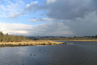
Burnaby Lake is a lake located in Burnaby, British Columbia and is the focal geographic feature and namesake of Burnaby Lake Regional Park. The lake occupies 3.11 square kilometres of land, and is home to a large variety of wildlife. At least 70 species of birds make the lake and surrounding areas their home, and about 214 species of birds visit the lake throughout the year. The park has been managed by the Metro Vancouver Parks Department since 1977.
The Brunette River runs through East Burnaby, New Westminster and Coquitlam, flowing out of Burnaby Lake and to the Fraser River. It is the final outflow of the Central Valley Watershed, which consists of most streams between the Ulksen and Burnaby Heights. According to a map and materials by Heritage Advisory Committee and Environment and Waste Management Committee of the City of Burnaby (1993), the number of native campsites discovered on the shores of the Fraser River, Burrard Inlet and Deer Lake and some petroglyphs suggest that the area was used extensively by local aboriginal peoples such as the Squamish, Musqueam and Kwantlen for hunting and fishing before the arrival of European settlers.
The Central Valley Greenway (CVG) is a 24-kilometre pedestrian and cyclist route in Metro Vancouver, running from Science World in Vancouver to New Westminster, through Burnaby. The greenway officially opened on June 27, 2009, with opening celebrations, guided bike tours, and walking tours on sections of the route. Despite its official opening, some sections are complete on an interim basis and are anticipated to be upgraded in the future.
Glenora is a residential neighbourhood in the city of Edmonton, Alberta, Canada, overlooking the North Saskatchewan River valley.
Two different neighbourhoods located in Langford, British Columbia in Greater Victoria on southern Vancouver Island include the name Goldstream.

Royal Columbian Hospital (RCH) is among the oldest hospitals in British Columbia and one of the busiest in the Fraser Health Authority. It is located in New Westminster overlooking the Fraser River and is the only hospital in the Lower Mainland that is immediately adjacent to a Skytrain station (Sapperton).
Fraser Mills was a municipality in British Columbia on the north bank of the Fraser River that was incorporated in 1913, but has since amalgamated with the City of Coquitlam.


