
Poplar Island is an uninhabited island located at the east end of the northern arm of the Fraser River in the City of New Westminster, [1] British Columbia. It is the last large undiked island in the Fraser River's North Arm.
Poplar Island is an uninhabited island located at the east end of the northern arm of the Fraser River in the City of New Westminster, [1] British Columbia. It is the last large undiked island in the Fraser River's North Arm.

In 1879, the federal government allocated four reserves to people from "All Coastal Tribes", and designated the "common reserve" as the New Westminster Indian Band, which included 27 acres (110,000 m2) on Poplar Island. [2] The reserve on Poplar Island was used as an Aboriginal smallpox victim quarantine area and a cemetery. Informants from the New Westminster Indian Band identified the reserve as a site of burials for people from the Kwantlen First Nation. [3] For decades, the Poplar Island reserve was designated as belonging to "all coast tribes". [4]
During World War I the New Westminster Construction and Engineering Company built both a massive shipyard on the island and a bridge connecting it to New Westminster. During the war years, hundreds of workers built, among other things, four warships for the government of France. [4] Cargo vessels built in the shipyard include the War Kitimat, War Comox, War Edensaw, and the War Ewen . [5] [6] Ship launching ways are still visible on the island’s upriver end. [7]
The B.C. government included the island in its "nature legacy" program in 1995, and it was to be held by the Metro Vancouver's park department as a strictly protected nature reserve, in perpetuity. [4]

Comox is a town on the southern coast of the Comox Peninsula in the Strait of Georgia on the eastern coast of Vancouver Island, British Columbia. Thousands of years ago, the warm dry summers, mild winters, fertile soil, and abundant sea life attracted First Nations, who called the area kw'umuxws.

The Regional District of Comox-Strathcona was a regional district of British Columbia, Canada, from 1967 to 2008. On February 15, 2008, the regional district was abolished and replaced by two successor regional districts, Comox Valley and Strathcona.
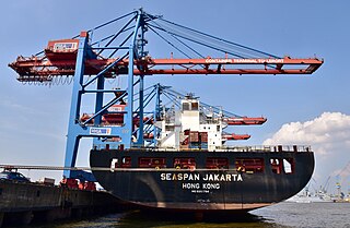
Seaspan ULC provides marine-related services to the Pacific Northwest. Within the Group are three shipyards, an intermodal ferry and car float business, along with a tug and barge transportation company that serves both domestic and international markets. Seaspan, is part of the Washington Companies that are owned by Dennis Washington. Kyle Washington, is the Executive Chairman of Seaspan, who has become a Canadian citizen.

The Musqueam Nation is a First Nation whose traditional territory encompasses the western half of what is now Greater Vancouver, in British Columbia, Canada. It is governed by a band council and is known officially as the Musqueam Indian Band under the Indian Act. "Musqueam" is an anglicization of the Hunquminum name xʷməθkʷəy̓əm, which means "place of the river grass" or "place where the river grass grows".
The Skatin First Nations, aka the Skatin Nations, are a band government of the In-SHUCK-ch Nation, a small group of the larger St'at'imc people who are also referred to as Lower Stl'atl'imx. The Town of Skatin - the St'at'imcets version of the Chinook Jargon Skookumchuck- is located 4 km south of T'sek Hot Spring- alt. spelling T'sek Hot Spring - commonly & formerly named both St. Agnes' Well & Skookumchuck Hot Springs The community is 28 km south of the outlet of Lillooet Lake on the east side of the Lillooet River. It is approximately 75 km south of the town of Pemberton and the large reserve of the Lil'wat branch of the St'at'imc at Mount Currie. Other bands nearby are Samahquam at Baptiste Smith IR on the west side of the Lillooet River at 30 km. and Xa'xtsa First Nations; the latter is located at Port Douglas, near the mouth of the Lillooet River where it enters the head of Harrison Lake. The N'Quatqua First Nation on Anderson Lake, between Mount Currie and Lillooet, was at one time involved in joint treaty negotiations with the In-SHUCK-ch but its members have voted to withdraw, though a tribal council including the In-SHUCK-ch bands and N'Quatqua remains, the Lower Stl'atl'imx Tribal Council.
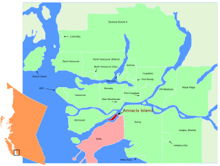
Annacis Island is a narrow island under the jurisdiction of City of Delta in Lower Mainland, British Columbia, located just downstream of the south arm of the Fraser River bifurcation between Lulu Island to the north and the Delta peninsula to the south. The island is now mostly an industrial zone, and contains one of Metro Vancouver's secondary wastewater treatment plants, the Annacis Island Wastewater Treatment Plant. The island is also home to the British Columbia Institute of Technology's Annacis Island campus.
The Red Bluff First Nation is a Dakelh First Nations government located in the northern Fraser Canyon region of the Canadian province of British Columbia. It is a member of the Carrier-Chilcotin Tribal Council, which includes both Tsilhqot'in and Carrier (Dakelh) communities.
The Tlʼetinqox-tʼin Government Office is a First Nations government located in the Chilcotin District in the western Central Interior region of the Canadian province of British Columbia. Governing a reserve communities near Alexis Creek known as Anaham Reserve First Nations or Anaham, it is a member of the Tsilhqotʼin Tribal Council aka known as the Tsilhqotʼin National Government. The main reserve is officially known as Anahim's Flat No. 1, and is more commonly as Anaham. Other reserves are Anahim's Meadow No. 2 and 2A, and Anahim Indian Reserves Nos. 3 through 18. Anaham, or Anahim and Alexis were chiefs of the Tsilhqotʼin during the Chilcotin War of 1864, although they and their people did not take part in the hostilities.
McMillan Island is an island in the Fraser River, British Columbia, Canada, also known as McMillan Slough..
The ƛoʔos Klahoose are one of the three groups comprising the ʔayʔaǰuθəm Tla'Amin or Mainland Comox. The other two divisions of this once-populous group are the χʷɛmaɬku Homalco and Sliammon. The Klahoose, Homalco and Sliammon are, according to oral tradition, the descendants of the survivors of the Great Flood. The three groups were split by colonialism into different band councils but united historically as the Tla A'min, known as the Mainland Comox, and K’ómoks, the larger grouping of the Comox people, also known as the Island Comox and before the merger with the Laich-kwil-tach culture. Historically both groups are a subgroup of the Coast Salish though the K’ómoks name is from, and their language today, is the Lik'wala dialect of Kwak'wala. The ancestral tongue is the Comox language, though the Sahtloot/Island dialect is extinct.
The Comox Valley Regional District is a regional district in British Columbia, Canada. It was created on February 15, 2008, encompassing the southeastern portions of the former Regional District of Comox-Strathcona, and centred about the Comox Valley. The partition left the new Comox Valley Regional District with only 8.4 percent of the former Comox-Strathcona's land area, but 57.9 percent of its population. The CVRD covers an area of 2,425 square kilometres, of which 1,725 square kilometres is land, and serves a population of 72,445 according to the 2023 Census. The district borders the Strathcona Regional District to the northwest, the Alberni-Clayoquot Regional District to the southwest, and the Regional District of Nanaimo to the southeast, as well as the qathet Regional District along the Strait of Georgia to the east.

The Katzie First Nation or Katzie Nation is the band government of the Katzie people of the Lower Fraser Valley region of British Columbia, Canada.
The Sq'éwlets First Nation (Scowlitz) is the band government of Skaulits subgroup of the Stó:lō people located on Harrison Bay in the Upper Fraser Valley region between Chehalis (E) and Lake Errock, British Columbia, Canada (W). They are a member government of the Stó:lō Tribal Council.
The New Westminster Indian Band is an Indian Act band government based at suite 105 – 3680 Rae Avenue in Vancouver, British Columbia. The band administration uses the unofficial name "Qayqayt First Nation" in its public communication. The New Westminster Indian Band is one of the smallest First Nations in Canada and the only one registered without a land base.
The Tlowitsis Nation, formerly the Klowitsis Tribe, the Turnour Island Band and the Tlowitsis-Mumtagila First Nation, is the Indian Act band government of the Ławit'sis (Tlowitsis) tribe of the Kwakwaka'wakw peoples, located in the Queen Charlotte Strait-Johnstone Strait area in the Discovery Islands between Vancouver Island and the British Columbia mainland in Canada. Ławit'sis territory covers parts of northern Vancouver Island, Johnstone Strait, and adjoining inlets of the mainland. Kalugwis, on Turnour Island, was their principal community in times past, but the band's offices are in the city of Campbell River to the southeast. Hanatsa IR No. 6 on Port Neville is the most populated of the band's Indian reserves.
Port Hammond, commonly known as Hammond, is a community on the Fraser River within the city of Maple Ridge, British Columbia, Canada, near its border with the City of Pitt Meadows and just east of the Golden Ears Bridge.
The Leq'á:mel First Nation, formerly known as Lakahahmen First Nation, is a First Nations band government whose community and offices are located in the area near Deroche, British Columbia in the Fraser Valley region in Canada, about 12 kilometres east of the District of Mission. They are a member government of the Sto:lo Nation Chiefs Council, which is one of two tribal councils of the Sto:lo.
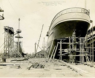
SS War Kitimat was a freighter built in Canada for wartime service during the First World War. She was steam-powered, with a hull made of wood.
The company built four ships, the War Comox, War Edensaw, War Kitimat and War Ewen. The War Comox was first launched in April, 1918, but completion was held up as the shipyard waited for equipment from suppliers.
![]() Media related to Poplar Island, British Columbia at Wikimedia Commons
Media related to Poplar Island, British Columbia at Wikimedia Commons
49°12′00″N122°56′00″W / 49.20000°N 122.93333°W
Neighbourhoods in New Westminster, British Columbia | |
|---|---|
| Main neighbourhoods | |
| Other areas | |