Queensborough, New Westminster

Last updated

Queensborough
Koonspa
Neighbourhood of New Westminster
Poplar Island and Fraser River, New Westminster - panoramio.jpg
Queensborough in foreground
Map of Queensborough within New Westminster.png
Location of Queensborough shown in red
15 Metro Vancouver Regional District British Columbia.svg
Red pog.svg
Queensborough
Location of Queensborough within Metro Vancouver
Coordinates: 49°11′00″N122°56′00″W / 49.18333°N 122.93333°W / 49.18333; -122.93333
CountryCanada
ProvinceBritish Columbia
Region Lower Mainland
Regional District Metro Vancouver
City New Westminster
Incorporated1911
Government
   Mayor Patrick Johnstone
   MP (Fed.) Peter Julian (NDP)
   MLA (Prov.) Aman Singh (BC NDP)
Population
 (2021)
  Total10,983 [1]
Time zone UTC−8 (PST)
  Summer (DST) UTC−7 (PDT)

Queensborough is a neighbourhood in the city of New Westminster, British Columbia, Canada. It is on the eastern tip of Lulu Island on the Fraser River. [2]

Contents

At the north end of Queensborough is a new development called Port Royal. To the south is Thompson's Landing, to the west is the industrial area of Tree Island, and to the east is the Fraser River. Access to Annacis Island, an industrial park area and site of one of the GVRD's sewage plants, is via a bridge towards the east end of Queensborough, though the island itself is not part of the City of New Westminster.

History

Queensborough was the name originally chosen for the colonial capital by Royal Engineers Commander Colonel Richard Clement Moody. Queen Victoria designated New Westminster instead of Queensborough as her new capital's name. In the 1860s, a survey of Lulu Island by the Royal Engineers resulted in the eastern tip of the island being designated a military reserve for the defense of New Westminster. This portion of land was not incorporated into the new Township of Richmond in 1879. Instead the rapidly growing City of New Westminster annexed the area in 1889. The City received title to the entire Military Reserve from the Provincial Government and it decided to subdivide the area for sale in 1890. A bridge was constructed to reach the area from the Mainland and the lands sold at auction.

The name Queensborough for this neighbourhood of the City was formally established in 1911 when the Queensborough Post Office was opened by early community leader and Italian immigrant Anthony Sprice. [3] In the Chinook Jargon, it is said that an adaption of the name Queensborough – "Koonspa" – is the usual name for New Westminster as a whole. [4]

With its many lumber mills and canneries the area became a focus of new immigrants looking for employment and cheap lots to establish family homes. These early groups built their own cultural halls, churches and had many different mutual aid societies. However, the entire community united at time under the Queensborough Ratepayers Association founded in 1911. This group continues to operate and is often cited as the oldest ratepayers association in British Columbia. Early immigrants came from Asia and Europe; including the Japanese, Chinese, Indians, Italians, Greeks, Slovaks, Ukrainians, and Finns. The community grew slowly but developed a unique sense of place because of its unique cultural composition.

Queensborough Bridge Queensborough Bridge.jpg
Queensborough Bridge

Queensborough is today a growing suburban district with a rapidly redeveloped waterfront area known as Port Royal. Queensborough is connected to the rest of New Westminster by the Queensborough Bridge and Annacis Island in Delta by the Derwent Way Bridge. Furthermore, the city of New Westminster has also implemented a ferry service that takes city inhabitants and tourists from Port Royal in Queensborough to the Westminster Quay. [5] It is served by Highway 91A. Many new homes in the area are built to resemble old heritage-style homes.

In the heart of Queensborough is Ryall Park. This is also where Queensborough Community Centre is located. The park has several features which include playgrounds, a spray park and Boro All Wheel Park (a skatepark and a bike park). Renovations are currently under way converting Ryall's bike park section of Boro All Wheel Park into an off-leash park for dogs. This park will be split and will have designated areas for small dogs, and all other dogs. Queensborough Middle School and Queen Elizabeth Elementary School are also located in the same park-block.

In 2004 a shopping centre called Queensborough Landing was built.

Demographics

Queensborough Sikh temple, 1931 GurdwaraSukhSagar1931.jpg
Queensborough Sikh temple, 1931
Population history
YearPop.±%
2001 4,553    
2006 5,502+20.8%
2011 7,125+29.5%
2016 8,727+22.5%
2021 10,983+25.9%
Source: Statistics Canada

A legacy of early 20th century settlement, the neighbourhood has a large South Asian population. In recent decades the European and East Asian population have grown with the area witnessing increasing residential development and infill. In the 1960s, there were many new European immigrants; Italians, Portuguese, Polish, Romanian and Russian. In the 1970s, Asian immigration increased; a new wave of Indian immigrants settled in the area, along with Chinese and Filipino newcomers.[ citation needed ]

Panethnic groups in Queensborough, New Westminster (2001−2021)
Panethnic group2021 [6] [1] 2016 [7] 2011 [8] 2006 [9] 2001 [10] [11]
Pop. %Pop.%Pop.%Pop.%Pop.%
South Asian 2,9902,3702,6002,0801,940
European [lower-alpha 1] 2,4602,5702,2351,8551,645
East Asian [lower-alpha 2] 2,0801,620865595305
Southeast Asian [lower-alpha 3] 2,0101,470915455175
Latin American 31512017010015
Middle Eastern [lower-alpha 4] 3107511055155
African 20015565110165
Indigenous 1601604018565
Other/multiracial [lower-alpha 5] 410160854075
Total responses10,9308,6957,0955,4804,545
Total population10,9838,7277,1255,5024,553

Education

One elementary school, Queen Elizabeth Elementary School, and one middle school, Queensborough Middle School, are located in the neighbourhood.

A Library and community centre were also recently opened. The community centre has a newly renovated exercise area and a gymnasium where local residents partake in physical games.

See also

Notes

  1. Statistic includes all persons that did not make up part of a visible minority or an indigenous identity.
  2. Statistic includes total responses of "Chinese", "Korean", and "Japanese" under visible minority section on census.
  3. Statistic includes total responses of "Filipino" and "Southeast Asian" under visible minority section on census.
  4. Statistic includes total responses of "West Asian" and "Arab" under visible minority section on census.
  5. Statistic includes total responses of "Visible minority, n.i.e." and "Multiple visible minorities" under visible minority section on census.

Related Research Articles

<span class="mw-page-title-main">Lower Mainland</span> Region in British Columbia, Canada

The Lower Mainland is a geographic and cultural region of the mainland coast of British Columbia that generally comprises the regional districts of Metro Vancouver and the Fraser Valley. Home to approximately 3.05 million people as of the 2021 Canadian census, the Lower Mainland contains sixteen of the province's 30 most populous municipalities and approximately 60% of the province's total population.

<span class="mw-page-title-main">Richmond, British Columbia</span> City in British Columbia, Canada

Richmond is a city in the coastal Lower Mainland region of British Columbia, Canada. Mainly a suburban city, it occupies almost the entirety of Lulu Island, between the two estuarine distributaries of the Fraser River. Encompassing the adjacent Sea Island and several other smaller islands and uninhabited islets to its north and south, the suburb neighbours Vancouver and Burnaby on the Burrard Peninsula to the north, New Westminster and Annacis Island to the east, Delta to the south, and the Strait of Georgia to the west.

<span class="mw-page-title-main">View Royal</span> Town in British Columbia, Canada

View Royal is a town in Greater Victoria and a member municipality of the Capital Regional District of British Columbia, Canada. View Royal has a population of 11,575 residents. With over 700 hectares of parkland, View Royal includes Thetis, McKenzie, Pike, and Prior Lakes and portions of Esquimalt Harbour and Portage Inlet.

<span class="mw-page-title-main">Golden, British Columbia</span> Town in British Columbia, Canada

Golden is a town in southeastern British Columbia, Canada, 262 kilometres (163 mi) west of Calgary, Alberta, and 713 kilometres (443 mi) east of Vancouver.

<span class="mw-page-title-main">Sunshine Coast Regional District</span> Regional district in British Columbia, Canada

The Sunshine Coast Regional District is a regional district in British Columbia, Canada. It is located on the southern mainland coast, across Georgia Strait from Vancouver Island. It borders on the qathet Regional District to the north, the Squamish-Lillooet Regional District to the east, and, across Howe Sound, the Metro Vancouver District to the south. The regional district offices are located in the District Municipality of Sechelt.

<span class="mw-page-title-main">North Cowichan</span> District municipality in British Columbia, Canada

North Cowichan is a district municipality established in 1873 on Vancouver Island, in British Columbia, Canada. The municipality is part of the Cowichan Valley Regional District. North Cowichan is noted for a landscape including forests, beaches, rivers, and lakes. The municipality encompasses the communities of Chemainus; Westholme; Crofton; Maple Bay; and "the South End". The latter is an informal name for a built-up area which is essentially a suburb of the City of Duncan, a separate municipality.

<span class="mw-page-title-main">Central Saanich</span> District municipality in British Columbia, Canada

Central Saanich is a district municipality in Greater Victoria, British Columbia, Canada, and a member municipality of the Capital Regional District. It is located on the Saanich Peninsula, in the far south-east of Vancouver Island. It is the traditional territory of the W̱SÁNEĆ people. The district began as a farming community, and many hobby farms, along working farms and vineyards, still exist. In recent decades, the area has seen increasing residential, commercial, and industrial development, especially around the neighbourhoods of Brentwood Bay and Saanichton, which are occasionally referred to as separate communities.

The District of Metchosin is a municipality and community in Greater Victoria on the southern tip of Vancouver Island in British Columbia, Canada. It is a coastal community adjacent to the Strait of Juan de Fuca. Metchosin is part of the Western Communities and one of the 13 regional municipalities.

<span class="mw-page-title-main">South Asian Canadians</span> Ethnic group

South Asian Canadians are Canadians who were either born in or can trace their ancestry to South Asia or the Indian subcontinent, which includes the nations of India, Pakistan, Bangladesh, Afghanistan, Nepal, Bhutan, Sri Lanka and the Maldives. The term also includes immigrants from South Asian communities in East and South Africa, Guyana, Trinidad and Tobago, Fiji, Mauritius and the rest of the world.

<span class="mw-page-title-main">Cariboo Regional District</span> Regional district in British Columbia, Canada

The Cariboo Regional District spans the Cities and Districts of Quesnel, Williams Lake, 100 Mile House, and Wells in the Central Interior of British Columbia.

<span class="mw-page-title-main">New Westminster—Burnaby</span> Federal electoral district in British Columbia, Canada

New Westminster—Burnaby is a federal electoral district in British Columbia, Canada, that was represented in the House of Commons of Canada from 1988 to 1997 and since 2015.

<span class="mw-page-title-main">Port Hardy</span> District municipality in British Columbia, Canada

Port Hardy is a district municipality in British Columbia, Canada located on the north-east tip of Vancouver Island. Port Hardy has a population of 3,902 as of the 2021 census.

The demographics of Toronto, Ontario, Canada make Toronto one of the most multicultural and multiracial cities in the world. In 2021, 57.0 percent of the residents of the metropolitan area belonged to a visible minority group, compared with 51.4 percent in 2016, and 13.6 percent in 1981. Toronto also has established ethnic neighbourhoods such as the multiple Chinatowns, Corso Italia, Little Italy, Little India, Greektown, Koreatown, Little Tokyo, Little Jamaica, Little Portugal, Little Malta, Roncesvalles (Polish), and Bloor West Village (Ukrainian), all of which celebrate the city's multiculturalism. Data from the suburban municipalities are also included for some metrics as most of these municipalities are part of the Toronto CMA.

The demographics of Metro Vancouver indicate a multicultural and multiracial region. Metro Vancouver is a metropolitan area, with its major urban centre being Vancouver, British Columbia, Canada. The Vancouver census metropolitan area, as defined by Statistics Canada, encompasses roughly the same territory as the Metro Vancouver Regional District, a regional district in British Columbia. The regional district includes 23 local authorities. Figures provided here are for the Vancouver census metropolitan area and not for the City of Vancouver.

<span class="mw-page-title-main">Demographics of British Columbia</span>

British Columbia is a Canadian province with a population of about 5.6 million people. The province represents about 13.2% of the population of the Canadian population. Most of the population is between the ages of 15 and 49. About 60 percent of British Columbians have European descent with significant Asian and Aboriginal minorities. Just under 30% of British Columbians are immigrants. Over half of the population is irreligious, with Christianity and Sikhism being the most followed religions.

<span class="mw-page-title-main">Asian Canadians</span> Ethnic group in Canada

Asian Canadians are Canadians who were either born in or can trace their ancestry to the continent of Asia. Canadians with Asian ancestry comprise both the largest and fastest growing group in Canada, after European Canadians, forming approximately 20.2 percent of the Canadian population as of 2021. Most Asian Canadians are concentrated in the urban areas of Southern Ontario, Southwestern British Columbia, Central Alberta, and other large Canadian cities.

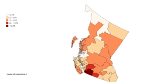
South Asian Canadians in Metro Vancouver are the third-largest pan-ethnic group in the region, comprising 369,295 persons or 14.2 percent of the total population as of 2021. Sizable communities exist within the city of Vancouver along with the adjoining city of Surrey, which houses one of the world's largest South Asian enclaves.

<span class="mw-page-title-main">South Asian Canadians in British Columbia</span> Ethnic group

The South Asian community in British Columbia was first established in 1897. The first immigrants originated from Punjab, British India, a northern region and state in modern-day India and Pakistan. Punjabis originally settled in rural British Columbia at the turn of the twentieth century, working in the forestry and agricultural industries.

<span class="mw-page-title-main">Sikhism in Greater Vancouver</span> Religious community

Sikhism in Greater Vancouver is one of the main religions across the region, especially among the Indo-Canadian population. The Sikh community in Vancouver is the oldest, largest and most influential across Canada, having begun in the late 19th century.

Edmonds is a neighbourhood in the southeast of Burnaby, British Columbia, Canada. It is one of the city's four officially designated town centres.

References

  1. 1 2 Government of Canada, Statistics Canada (26 October 2022). "Census Profile, 2021 Census of Population Profile table 9330200.02 British Columbia [Census tract]". www12.statcan.gc.ca. Retrieved 13 April 2024.
  2. "Queensborough (community)". BC Geographical Names .
  3. "New Westminster Archives Results Page". Archived from the original on 23 January 2023. Retrieved 23 January 2023.
  4. A Voice Great Within Us, Charles Lillard and Terry Glavin, Transmontanus Books
  5. "Quayside to Queensborough Ferry Back & Running All Summer Long!". Tourism New West. 1 August 2018. Archived from the original on 12 August 2020. Retrieved 14 April 2020.
  6. Government of Canada, Statistics Canada (26 October 2022). "Census Profile, 2021 Census of Population Profile table 9330200.01 British Columbia [Census tract]". www12.statcan.gc.ca. Retrieved 13 April 2024.
  7. Government of Canada, Statistics Canada (27 October 2021). "Census Profile, 2016 Census 9330200.00 [Census tract], British Columbia and Vancouver [Census metropolitan area], British Columbia". www12.statcan.gc.ca. Archived from the original on 29 April 2021. Retrieved 13 April 2024.
  8. Government of Canada, Statistics Canada (27 November 2015). "NHS Profile, 9330200.00, British Columbia, 2011". www12.statcan.gc.ca. Retrieved 13 April 2024.
  9. Government of Canada, Statistics Canada (23 July 2020). "Census tract profile for 0200.00 (CT), Vancouver (CMA) and British Columbia". www12.statcan.gc.ca. Retrieved 13 April 2024.
  10. Government of Canada, Statistics Canada (23 December 2013). "2001 Census Area Profiles Profile of Citizenship, Immigration, Birthplace, Generation Status, Ethnic Origin, Visible Minorities and Aboriginal Peoples, for Census Metropolitan Areas, Tracted Census Agglomerations and Census Tracts, 2001 Census". www12.statcan.gc.ca. Retrieved 13 April 2024.
  11. Government of Canada, Statistics Canada (23 December 2013). "Population and Dwelling Counts for Census Metropolitan Areas, Census Agglomerations and Census Tracts, 2001 and 1996 Censuses - 100% Data". www12.statcan.gc.ca. Retrieved 13 April 2024.