Doddington, Kent

Last updated

Doddington
Aerial Picture Westend.jpg
Aerial photo of Doddington
Kent UK location map.svg
Red pog.svg
Doddington
Location within Kent
Population557 
OS grid reference TQ 934572
District
Shire county
Region
Country England
Sovereign state United Kingdom
Post town Sittingbourne
Postcode district ME9
Dialling code 01795
Police Kent
Fire Kent
Ambulance South East Coast
UK Parliament
List of places
UK
England
Kent
51°16′53″N0°46′23″E / 51.2815°N 0.773°E / 51.2815; 0.773

Doddington is a village and civil parish in the district of Swale in Kent, England. The Syndale Valley shelters the central part in the Kent Downs Area of outstanding natural beauty. Today the village is notable for Doddington Place Gardens, for its remarkably well kept buildings and its house prices show higher prices than the home counties average.

Contents

History

Within the parish at Sharsted Court, earthworks excavated were believed remains of an Iron Age Belgic Fort (100 BC – 43 AD). However the current village settlement dates from the 11th century. [1]

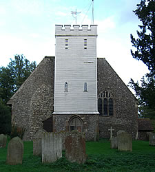
Of particular note is Doddington Church with the unusual dedication of "The (decollation) Beheading of St. John the Baptist". The dedication dates from at least 1467 when it is referenced in a will. [2]

Doddington Church 2006 DoddingtonChurch Sept2006.jpg
Doddington Church 2006

Other notable buildings within the parish are: Doddington Place built in 1870 for the Croft family (of 'Croft original sherry' fame) [3] who owned it until 1906 when the Jeffreys and Oldfied families jointly purchased it. It is still owned by the Oldfield family and the Doddington Place Gardens are open to the public and have achieved listed status; [4] in its grounds are the Place, a much-altered house, Park House [5] and Park Cottage, also listed with fascinating history, as Grade II. [6]

Attractions and amenities

Within the parish just 500 metres (1,600 ft) to the north east is Sharsted Court, a Medieval Wealden hall house distinctive of this area, the Weald, however a building on the site dates from at least 1080; today a large romantic rambling manor house due to the many additions and alterations over the centuries. It is owned by former Wimbledon champion Virginia Wade.

The village has an award-winning butchers shop, Doughty's, owned by the Doughty family since 1919 (and a butchers shop since 1789), with its own slaughter house. [7]

The village has a strong community spirit with numerous clubs and groups, which include as of 2013: An allotments association, amateur dramatics (The Valley Players), singing (Cantiana), parent/toddler group (Buddies), health and fitness (Medau) and tied in with the neighbouring village of Newnham, folk dancing, Women's Institute and brownies groups.

Related Research Articles

<span class="mw-page-title-main">Lingfield, Surrey</span> Village, civil parish and post town in Tandridge District, Surrey, South East England

Lingfield is a village and civil parish in the Tandridge district of Surrey, England, approximately 23 miles (37 km) south of London. Several buildings date from the Tudor period and the timber-frame medieval church is Grade I listed. The stone cage or old gaol, constructed in 1773, was last used in 1882 to hold a poacher.

<span class="mw-page-title-main">Shalford, Surrey</span> Village in England

Shalford is a village and civil parish in the Guildford district, in Surrey, England on the A281 Horsham road immediately south of Guildford. It has a railway station which is between Guildford and Dorking on the Reading to Gatwick Airport line. In 2011 the parish had a population of 4142.

<span class="mw-page-title-main">Bearsted</span> Village in Kent, England

Bearsted is a village and civil parish with railway station in mid-Kent, England, two miles (3.2 km) east of Maidstone town centre.

<span class="mw-page-title-main">Hollingbourne</span> Village near Maidstone, Kent, England

Hollingbourne is a village and civil parish in the borough of Maidstone in Kent, England. The parish is located on the southward slope of the North Downs to the east of the county town, Maidstone. The parish population is around 900 and has three conservation areas: Upper Street in the village centre and the outlying hamlets of Broad Street and Eyhorne Street.

<span class="mw-page-title-main">Lamberhurst</span> Human settlement in England

Lamberhurst ( is a village and civil parish in the borough of Tunbridge Wells in Kent, England. The parish contains the hamlets of The Down and Hook Green. At the 2001 Census it had a population of 1,491, increasing to 1,706 at the 2011 Census.

<span class="mw-page-title-main">Alfold</span> Village in England

Alfold is a village and civil parish in Surrey, England on the West Sussex border. Alfold is a dispersed or polyfocal village in the Green Belt, which is buffered from all other settlements. The Greensand Way runs north of the village along the Greensand Ridge and two named localities exist to the north and south of the historic village centre which features pubs, a set of stocks and a whipping post.

<span class="mw-page-title-main">Hartley, Sevenoaks</span> Human settlement in England

Hartley is a village and civil parish in the Sevenoaks district of Kent, England. It is located 7 miles (11 km) south west of Gravesend and the same distance south east of Dartford.

<span class="mw-page-title-main">Tichborne</span> Human settlement in England

Tichborne is a village and civil parish 4 miles (6.4 km) east of Winchester in Hampshire, England.

<span class="mw-page-title-main">Chartham</span> Village and civil parish in Kent, England

Chartham is a village and civil parish in the Canterbury district of Kent, England. It is situated on the Ashford side of the city, and is in the North Downs area of Outstanding Natural Beauty, 2.3 mi (4 km) south west of Canterbury, England. The Great Stour Way path passes through the village. A paper mill in the village that had specialised in the production of tracing paper since 1938 has in 2022 closed down. There are numerous arable farms and orchards in the parish. The village has an unstaffed station, Chartham, and has recently upgraded its staffed level crossing to an automatic barrier. It has an outlying locality sharing in many of the community resources, Chartham Hatch. Its current

<span class="mw-page-title-main">Aldington, Kent</span> Human settlement in England

Aldington is a village and civil parish in the Ashford District of Kent, England. The village centre is eight miles (12 km) south-east of the town of Ashford. As with the village centre, set on a steep escarpment above agricultural Romney Marsh and the upper Stour is Aldington Knoll, which was used as a Roman burial barrow and later beacon, it has a panorama towards the English Channel and of low land such as Dungeness. At the 2021 Census the population included Bonnington.

<span class="mw-page-title-main">Ash, Surrey</span> Village in England

Ash is a village and civil parish in the far west of the borough of Guildford, Surrey. Ash is on the eastern side of the River Blackwater, with a station on the Reading-Guildford-Gatwick line, and direct roads to Aldershot, Farnham and Guildford. The 2011 census counted the residents of the main ward of Ash, which excludes Ash Vale, as 6,120. It is within the Blackwater Valley and adjoins the riverside in the east of that large town; Ash has a small museum in the local cemetery chapel, a large secondary school and a library.

<span class="mw-page-title-main">Newnham, Kent</span> Human settlement in England

Newnham is a village and civil parish in the Syndale valley in Kent, England, in the administrative borough of Swale near the medieval market town of Faversham.

<span class="mw-page-title-main">Teynham</span> Human settlement in England

Teynham is a large village and civil parish in the borough of Swale in Kent, England. The parish lies between the towns of Sittingbourne and Faversham, immediately north of the A2 road, and includes the hamlet of Conyer on an inlet of the Swale, the channel that separates mainland Kent from the Isle of Sheppey. Other hamlets include Deerton Street, Frognal, and Teynham Street.

<span class="mw-page-title-main">Warnham</span> Human settlement in England

Warnham is a village and civil parish in the Horsham district of West Sussex, England. The village is centred 2 miles (3.2 km) north-northwest of Horsham, 31 miles (50 km) from London, to the west of the A24 road. The parish is in the north-west of the Weald.

<span class="mw-page-title-main">Bredgar</span> Human settlement in England

Bredgar is a village and civil parish in the Borough of Swale, Kent, England.

<span class="mw-page-title-main">Sheldwich</span> Human settlement in England

Sheldwich is a village and civil parish in the far south of the Borough of Swale in Kent, England.

<span class="mw-page-title-main">Selling, Kent</span> Human settlement in England

Selling is a village and civil parish southeast of Faversham and west of Canterbury in Kent, England.

<span class="mw-page-title-main">Wotton, Surrey</span> Human settlement in England

Wotton is a well-wooded parish with one main settlement, a small village mostly south of the A25 between Guildford in the west and Dorking in the east. The nearest village with a small number of shops is Westcott. Wotton lies in a narrow valley, collecting the headwaters of the Tilling Bourne which then has its first combined flow in the Vale of Holmesdale. The parish is long north to south, reaching to the North Downs escarpment in the north to the escarpment of the Greensand Ridge at Leith Hill in the south.

<span class="mw-page-title-main">Sharsted Court</span> Building in Newnham, England

Sharsted Court is a grade I listed manor house set in woodland near the village of Newnham, Kent England. A house or lodge has been recorded at the site since the time of Odo de Bayeux in 1080, however the present building, exhibiting a number of later styles, principally dates from the 18th century. Earlier residents of the site may have included Iron Age settlers since excavations of earthworks on the estate in 1825 and 1880 revealed evidence of possible Belgic fortifications.

<span class="mw-page-title-main">Itchen Stoke and Ovington</span> Human settlement in England

Itchen Stoke and Ovington is an English civil parish consisting of two adjoining villages in Hampshire, England, 2 miles (3.2 km) west of Alresford town centre in the valley of the River Itchen, 5 miles (8.0 km) north-east of Winchester, and 2 miles (3.2 km) south-east of Itchen Abbas.

References

  1. "The History of Doddington". www.doddington-kent.org.uk. Retrieved 24 May 2022.
  2. "No.3 Doddington Church". twokentvillages.org. Retrieved 16 March 2012.
  3. "Doddington Place, Doddington Village in Kent". Archived from the original on 20 April 2012. Retrieved 6 October 2011.
  4. Historic England. "Details from listed building database (1000398)". National Heritage List for England . Retrieved 21 May 2012.
  5. Historic England. "Details from listed building database (1055783)". National Heritage List for England . Retrieved 21 May 2012.
  6. Historic England. "Details from listed building database (1343900)". National Heritage List for England . Retrieved 21 May 2012.
  7. "Doddington butcher S W Doughty named best in Britain". KentOnline. 31 March 2011. Retrieved 4 May 2013.