Swale is a local government district with borough status in Kent, England. The council is based in Sittingbourne, the borough's largest town. The borough also contains the towns of Faversham, Queenborough and Sheerness, along with numerous villages and surrounding rural areas. It includes the Isle of Sheppey and is named after The Swale, the narrow channel which separates Sheppey from the mainland part of the borough. Some southern parts of the borough lie within the Kent Downs, a designated Area of Outstanding Natural Beauty.

Faversham is a market town in Kent, England, 8 miles (13 km) from Sittingbourne, 48 miles (77 km) from London and 10 miles (16 km) from Canterbury, next to the Swale, a strip of sea separating mainland Kent from the Isle of Sheppey in the Thames Estuary. It is close to the A2, which follows an ancient British trackway which was used by the Romans and the Anglo-Saxons, and known as Watling Street. The name is of Old English origin, meaning "the metal-worker's village".

Sittingbourne is an industrial town in the Swale district, in Kent, southeast England, 17 miles (27 km) from Canterbury and 45 miles (72 km) from London, beside the Roman Watling Street, an ancient British trackway used by the Romans and the Anglo-Saxons.

Dunkirk is a village and civil parish between Faversham and Canterbury in southeast England. It lies on the Canterbury Road between Boughton under Blean and Harbledown. This was the main Roman road from the Kentish ports to London, also known as Watling Street.

Canterbury is a constituency in Kent represented in the House of Commons of the UK Parliament since 2017 by Rosie Duffield of the Labour Party.

Faversham and Mid Kent is a constituency represented in the House of Commons of the UK Parliament. Since 2015, the seat has been held by Helen Whately of the Conservative Party.
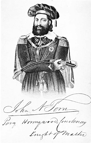
John Nichols Tom was a Cornish merchant and maltster who re-invented himself as Sir William Courtenay, stood for parliament in Canterbury, was convicted of perjury in a smuggling case, spent three years in the Kent County Lunatic Asylum, and, following his release, gathered a small band of followers and paraded in the Kent countryside. He, along with several of his followers, was killed in a confrontation with government soldiers in Bossenden Wood, in what has sometimes been called the last battle to be fought on English soil.

Blean is a village and civil parish in the Canterbury district of Kent, England. The civil parish is large and is mostly woodland, much of which is ancient woodland. The developed village within the parish is scattered along the road between Canterbury and Whitstable, in the middle of the Forest of Blean. The parish of St. Cosmus and St. Damian in the Blean was renamed "Blean" on 1 April 2019.
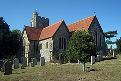
Lynsted is a village in Lynsted with Kingsdown civil parish in the Swale borough of Kent, England. The village is situated south of the A2 road between Faversham and Sittingbourne and the nearest M2 junction is Faversham three miles east. Lynsted is in many respects an archetypal old English village with church, churchyard with an ancient yew, pub and a duck pond. The village is locally referred to as Lovely, Lovely Lynsted and various songs have been written about it.

The Battle of Bossenden Wood took place on 31 May 1838 near Hernhill in Kent; it has been called the last battle on English soil. The battle was fought between a small group of labourers from the Hernhill, Dunkirk, and Boughton area and a detachment of soldiers sent from Canterbury to arrest the marchers' leader, the self-styled Sir William Courtenay, who was actually John Nichols Tom, a Truro maltster who had spent four years in Kent County Lunatic Asylum. Eleven men died in the brief confrontation: Courtenay, eight of his followers and two of those sent to apprehend them. The background context of the battle was the impact of new Poor Law and it has been linked with the Swing riots.

Teynham is a large village and civil parish in the borough of Swale in Kent, England. The parish lies between the towns of Sittingbourne and Faversham, immediately north of the A2 road, and includes the hamlet of Conyer on an inlet of the Swale, the channel that separates mainland Kent from the Isle of Sheppey. Other hamlets include Deerton Street, Frognal, and Teynham Street.

Ospringe is a village and area of Faversham in the English county of Kent. It is also the name of a civil parish, which since 1935 has not included the village of Ospringe.
Goodnestone is a village and former civil parish, now in the parish of Graveney with Goodnestone, in the Swale district of Kent, England. The village is mainly on the road 'Head Hill Road' towards Graveney. In 1961 the parish had a population of 58.

Graveney is a village and former civil parish, now in the parish of Graveney with Goodnestone, in the Swale district, in Kent, England. It is located between Faversham and Whitstable. The main part of the village is located along the intersection of Seasalter Road, Sandbanks Road and Head Hill Road, which is surrounded by farmland. The rest of the village is dispersed amongst this farmland. In 1961 the parish had a population of 305.

Stalisfield is a village in the borough of Swale in Kent, England, located on a secondary road about 1½ miles (2.4 km) north of Charing and 5 miles south west of Faversham. The parish includes the hamlet of Stalisfield Green.
Hernhill is a village and civil parish between Faversham and Canterbury in southeast England. The parish includes the hamlets of Crockham, Dargate, The Fostall, Lamberhurst, Oakwell, Staple Street, Thread, Waterham and Wey Street.

Leaveland is a hamlet and civil parish located in the Swale borough of Kent, South East England. In terms of topography, it is described as a "village surrounded by inhabited countryside", and is situated mostly on high ground. It is located 5 miles South of Faversham, West of Badlesmere, and on or close to the A251.The closest railway station to the area is Selling, which is just over three miles away, although Faversham station is more accessible and offers better services. The closest estuary is The Swale which separates the Isle of Sheppey from mainland Kent, and flows to the north of Faversham Creek.. Leaveland itself covers an area of 1.5 km2 and lies entirely within the Kent Downs Area of Outstanding Natural Beauty.
Denstroude is a dispersed hamlet located to the west of the A290 road north of Canterbury in Kent, England. It is a collection of houses and farms, one of which takes its name from the hamlet; the other being Parsonage Farm, although there is no church nearby.

Seasalter is a village in the Canterbury District of Kent, England. Seasalter is on the north coast of Kent, between the towns of Whitstable and Faversham, facing the Isle of Sheppey across the estuary of the River Swale. The settlement of Yorkletts is included in the ward. It is approximately 6 miles (10 km) north of Canterbury.