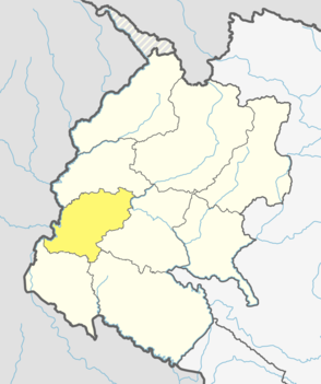
Dadeldhura district, a part of Sudurpashchim Province, is one of the seventy-seven districts of Nepal. The district, with Dadeldhura as its district headquarters, covers an area of 1,538 km2 (594 sq mi) and had a population of 126,162 in 2001 and 142,094 in 2011.

Dhading District, a part of Bagmati Province, is one of the seventy-seven districts of Nepal. The district, with Dhading Besi as its district headquarters, covers an area of 1,926 square kilometres (744 sq mi), had a population of 338,658 in 2001 and 336,067 in 2011.

Humla District, a part of Karnali Pradesh, is one of the seventy-seven districts of Nepal. The district, with Simikot as its district headquarters, covers an area of 5,655 km2 (2,183 sq mi) and has population of 50,858 as per the census of 2011. Humla is the 2nd largest district of Nepal. The Southern part and middle of Humla District is inhabited by Khas people, originating from Sinja valley, whereas the North border is mostly inhabited by Tibetans. Northern part of this district is administered by China since border skirmishes with India in 2020.

Taplejung District is one of 77 districts of Nepal and one of the 14 districts of Province No. 1. It is remotely located in the Himalayas in Eastern Nepal with Tibet to the north across the Himalayas. Taplejung is the third largest district of Nepal.
Lomanthang is a rural municipality in Mustang district in Gandaki Province of western Nepal. It is located at the northern end of the district, bordering the Tibet Autonomous Region of China to the north and Dalome rural municipality of Mustang in the south.

Bahrabise is an urban municipality located in Sindhupalchok District of Bagmati Province of Nepal.

Tatopani is a village in Sindhupalchok District in the Bagmati Zone of central Nepal. At the time of the 1991 Nepal census it had a population of 3102 and had 613 houses in the village. Majority people are of ethnic Sherpa and Tamang. Historically and today, it is a huge trading post between Nepal and China. People living here speak Nepali and Tibetan.There is a inactive volcano in there as well. Shrestha Sunil is Mayor there in Tatopani.Babita Sherpa could be organizing a donation on her birthday instead of taking any gifts for the welfare of people in Tatopani. The actual border crossing is at Kodari. The village was visited by and served as pitstop for famous indian scholar and travelogue Rahul Sankrityayan multiple times on his way to Tibet.
Chainpur is an ancient town in Jaya Prithvi Municipality and headquarters of Bajhang District in the Seti Zone of north-western Nepal. The formerly Village Development Committee was merged to form new municipality from 18 May 2014. At the time of the 1991 Nepal census it had a population of 4,143 and had 759 houses in the village. It has a grass runway in town with limited flights. From 1990-2002 the Peace Corps operated in Chainpur.
Makaising is a village development committee in Gorkha District in the Gandaki Zone of northern-central Nepal. At the time of the 1991 Nepal census it had a population of 2,231 and had 416 houses in the village.

Saldang is a village in Dolpa District in the Karnali Zone of north-western Nepal. Saldang lies at an altitude of 3,620 metres (11,880 ft) in the Nankhang Valley, in the historic Tibetan region of Dolpo. At the time of the 1991 Nepal census, Saldang had a population of 1,714 in 386 individual households, and as of 2011 it has a population of 2,103 people.
Chailahi is a town and Village Development Committee in Dang Deokhuri District in Lumbini Province of south-western Nepal. At the time of the 1991 Nepal census it had a population of 10,800 persons living in 1485 individual households. It lies in the east west highway and lied 23 km east to districts capital Ghorahi.
Dolphu is a village development committee in Mugu District in the Karnali Zone of north-western Nepal. It is the largest VDC in the district located in the east and borders Tibet, China. At the time of the 1991 Nepal census it had a population of 573 people living in 125 individual households.
Mugu is a village development committee in the Himalayas of Mugu District in the Karnali Zone of north-western Nepal. After Dolphu it is the second largest VDC in Mugu District which takes its name from it. It is located on the border with Tibet, China. At the time of the 1991 Nepal census it had a population of 898 people living in 181 individual households.

Kimathanka is a Village in Bhotkgola rural municipality of Sankhuwasabha District of Province No. 1, Nepal and serves as the Nepalese counterpart of the Nepal-China border at Zhentang. At the time of the 1991 census, it had a population of 303 people living in 50 individual households.
Olangchung Gola is a village in ward no. 7 of Phaktanglung rural municipality of Taplejung District of Province No. 1 in Nepal. Olangchung is surrounded by Lelep village to the east and Tibet to the north, Sankhuwasabha District to west and Mikkwakhola rural municipality to south. It is located to the north of Tamor River in the mountainous area in the northwest of Taplejung District bordering Tibet, China. Lately the river flowing next to the village is gradually expanding towards the village posing a serious threat of submerging the village.
Bangai is a village development committee in Kapilvastu District in the Lumbini Zone of southern Nepal. Locally, there are two places known by the name of Bangai, Gherawa Bangain in the east and Koili Bangain in the west, separated by the distance of 1 km. Mahendra Highway or East-West highway passes through it. The Banganga river marks the south boundary of Bangain. Manoharipur is the first adjacent village in the south of it which lies in the Kopawa V.D.C. Locally, Bangain is famous for its funeral site on the bank of Banganga known as Laxmanghat. It is also a major shopping hub within 5 km of its radius due to its proximity with the highway. At the time of the 1991 Nepal census it had a population of 2983 people living in 528 individual households.
Shivaraj is a Municipality in Kapilvastu District in the Lumbini Zone of southern Nepal. The former village development committee was transformed into Municipality from 18 May 2014 by merging the existing Birpur, Nepal, Chanai, Bishunpur, Jawabhari and Shivapur village development committees. At the time of the 1991 Nepal census it had a population of 7241 people living in 1067 individual households.

Kodari is a small village located at the border with Tibet-China. Kodari is at the end of Arniko Highway which connects Kodari with Kathmandu which is 144 KM away from Kodari. It is a border crossing from Nepal into the Tibet Autonomous Region.
Sundar Haraicha is a municipality in Morang District of Province No. 1 in Nepal that was established on 10 March 2017 by merging the former municipalities Sundar Dulari and Koshi Haraicha. At the time of the 2011 Nepal census, the localities formed had a joint population of 80,518 people living in 18,610 individual households.


