Olmsted County is a county in the U.S. state of Minnesota. As of the 2010 census, the population was 144,248, and has an estimated population of 156,277 as of 2018. Its county seat and largest city is Rochester.
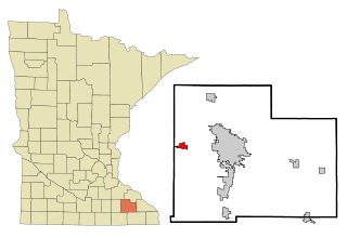
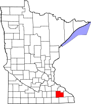
Byron is a city in Olmsted County, Minnesota, United States, approximately five miles (8 km) west of Rochester on U.S. Route 14. It is surrounded by Kalmar Township. The population was 4,914 at the 2010 census.

Viola is an unincorporated community in Viola Township, Olmsted County, Minnesota, United States. It is the site of a yearly Gopher Count festival, which began in 1874.
Verdi is an unincorporated community located in Verdi Township, Lincoln County, Minnesota, United States. The elevation is 1,762 feet (537 m). Verdi appears on the Verdi U.S. Geological Survey Map.
Ash Creek is an unincorporated community in Clinton Township, Rock County, Minnesota, United States. The community took its name from nearby Ash Creek.
Simpson is an unincorporated community in Pleasant Grove Township, Olmsted County, Minnesota, United States, near Rochester and Stewartville. The community is located along Olmsted County Road 1 near County Road 16 and 68th Street SE. Whitney Creek flows nearby.
Pleasant Grove is an unincorporated community in Pleasant Grove Township, Olmsted County, Minnesota, United States, near Rochester and Stewartville. The community is located along Olmsted County Road 1 near County Road 140.
Garden City is an unincorporated community and census-designated place (CDP) in Garden City Township, Blue Earth County, Minnesota, United States. Its population was 255 as of the 2010 census.
Delft is an unincorporated community located in Cottonwood County, Minnesota in Carson Township.
Potsdam is an unincorporated community in Farmington Township, Olmsted County, Minnesota, United States, near Elgin and Rochester. The community is located along State Highway 247 near Olmsted County Road 11. The boundary line between Olmsted and Wabasha counties is nearby.

Lime Creek is an unincorporated community in Belfast Township, Murray County, Minnesota, United States. It is located 2 miles northeast of Fulda.
High Forest is an unincorporated community in High Forest Township, Olmsted County, Minnesota, United States, near Rochester and Stewartville. The community is located near the junction of Olmsted County Roads 6 and 8, and Covill Street SW.
Genoa is an unincorporated community in Olmsted County, Minnesota, United States. The community is located along 75th Street NW near Exchange Avenue. Genoa is located within New Haven Township and Kalmar Township. Nearby places include Oronoco, Pine Island, and Byron. The South Branch Middle Fork of the Zumbro River flows nearby.
Chester is an unincorporated community in Marion Township, Olmsted County, Minnesota, United States. It is located immediately east of Rochester along U.S. Highway 14 near Olmsted County Roads 19 and 119. Chester Woods Park is nearby.
Hay Creek is an unincorporated community in Hay Creek Township, Goodhue County, Minnesota, United States.
Claybank is an unincorporated community in Goodhue Township, Goodhue County, Minnesota, United States.
Blakeley is an unincorporated community in Blakeley Township, Scott County, Minnesota, United States, along the Minnesota River. The community is located west-southwest of Belle Plaine near the junction of Scott County Roads 1, 6, and 60.
Meriden is an unincorporated community in Meriden Township, Steele County, Minnesota, United States, near Owatonna and Waseca. The community is located along SW 92nd Avenue near SW 13th Street.
Havana is an unincorporated community in Havana Township, Steele County, Minnesota, United States, near Owatonna. The community is located along SE 44th Avenue near SE 18th Street.
Smiths Mill is an unincorporated community in Blue Earth and Waseca counties in the U.S. state of Minnesota. The community is located along 631st Avenue near 206th Street and U.S. Highway 14. Smiths Mill is located within Le Ray Township in Blue Earth County; and also located within Janesville Township in Waseca County. Nearby places include Janesville and Eagle Lake.