Winona County is a county in the U.S. state of Minnesota. As of the 2020 census, its population was 49,671. Its county seat is Winona. Winona County comprises the Winona, MN Micropolitan Statistical Area.

Olmsted County is a county in the U.S. state of Minnesota. As of the 2020 census, the population is 162,847. Its county seat and most populous city is Rochester.

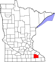
Hayfield is a city in Dodge County, Minnesota, United States. The population was 1,340 at the 2010 census.
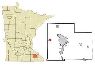
Byron is a city in Olmsted County, Minnesota, United States, approximately five miles (8 km) west of Rochester on U.S. Route 14. It is surrounded by Kalmar Township. The population was 6,312 at the 2020 census.

Rochester is a city in and the county seat of Olmsted County, Minnesota, United States. Located on rolling bluffs on the Zumbro River's south fork in Southeast Minnesota, the city is the home and birthplace of Mayo Clinic.
Pine Island is a city in Goodhue and Olmsted counties in the U.S. state of Minnesota. Most of Pine Island is in Goodhue County, but a small part extends into Olmsted County, making that portion part of the Rochester metropolitan area. As of the 2020 census, the population was 3,769.
Salem Corners is an unincorporated community in Salem Township, Olmsted County, Minnesota, United States, near Byron. The community is located near the junction of Olmsted County Roads 3 and 25.
Viola is an unincorporated community in Viola Township, Olmsted County, Minnesota, United States. It is the site of a yearly Gopher Count festival, which began in 1874.
South Troy is an unincorporated community in Zumbro Township, Wabasha County, Minnesota, United States. It is located on U.S. Highway 63 about 13 miles north of Rochester. Nearby places include Hammond, Zumbro Falls, Mazeppa, Potsdam, and Oronoco. Wabasha County Roads 7 and 11 are nearby.
Douglas is an unincorporated community in Olmsted County, Minnesota, United States. The community is located along 75th Street NW near its junction with County Road 3. Douglas is located within Kalmar Township and New Haven Township. Nearby places include Oronoco, Rochester, and the Douglas State Trail. The community is about two miles from the city of Rochester.
Simpson is an unincorporated community in Pleasant Grove Township, Olmsted County, Minnesota, United States, near Rochester and Stewartville. The community is located along Olmsted County Road 1 near County Road 16 and 68th Street SE. Whitney Creek flows nearby.
Pleasant Grove is an unincorporated community in Pleasant Grove Township, Olmsted County, Minnesota, United States, near Rochester and Stewartville. The community is located along Olmsted County Road 1 near County Road 140.
Potsdam is an unincorporated community in Farmington Township, Olmsted County, Minnesota, United States, near Elgin and Rochester. The community is located along State Highway 247 near Olmsted County Road 11. The boundary line between Olmsted and Wabasha counties is nearby.
High Forest is an unincorporated community in High Forest Township, Olmsted County, Minnesota, United States, near Rochester and Stewartville. The community is located near the junction of Olmsted County Roads 6 and 8, and Covill Street SW.
Genoa is an unincorporated community in Olmsted County, Minnesota, United States. The community is located along 75th Street NW near Exchange Avenue. Genoa is located within New Haven Township and Kalmar Township. Nearby places include Oronoco, Pine Island, and Byron. The South Branch Middle Fork of the Zumbro River flows nearby.
Chester is an unincorporated community in Marion Township, Olmsted County, Minnesota, United States. It is located immediately east of Rochester along U.S. Highway 14 near Olmsted County Roads 19 and 119. Chester Woods Park is nearby.
Shanty Town is an unincorporated community in Salem Township, Olmsted County, Minnesota, United States, near Byron. The community is located along Olmsted County Road 150 near 35th Street SW.
Ringe is an unincorporated community in Olmsted County, Minnesota, United States, near Rochester. The community is located along 75th Street NE near 40th Avenue NE. Ringe is located within Farmington Township and Haverhill Township.
Rock Dell is an unincorporated community in Rock Dell Township, Olmsted County, Minnesota, United States. The community is located near the junction of Olmsted County Roads 3, 26, and 126. The South Fork of the Zumbro River flows through the community. Nearby places include Byron, Hayfield, Stewartville, and Rochester.
Marion is an unincorporated community in Marion Township, Olmsted County, Minnesota, United States.