The Douglas Bay Horse Tramway on the Isle of Man runs along the seafront promenade for approximately 1.6 miles (2.6 km), from the southern terminus at the Victoria Pier, adjacent to the Isle of Man Sea Terminal, to Derby Castle station, the southern terminus of the Manx Electric Railway, where the workshops and sheds are located. It is a distinctive tourist attraction. However works have been underway to relay all of the track in 2019 and at present only a third is usable, with no published completion date for the works.

The Manx Electric Railway is an electric interurban tramway connecting Douglas, Laxey and Ramsey in the Isle of Man. It connects with the Douglas Bay Horse Tramway at its southern terminus at Derby Castle at the northern end of the promenade in Douglas, and with the Snaefell Mountain Railway at Laxey. Many visitors take an excursion on the trams. It is the oldest electric tram line in the world whose original rolling stock is still in service.

The Snaefell Mountain Railway is an electric mountain railway on the Isle of Man in Europe. It joins the village of Laxey with the summit of Snaefell, at 2,036 feet (621 m) above sea level the highest point on the island. It connects with the Manx Electric Railway (MER) in Laxey. The line is 5 miles (8 km) long, is built to 3 ft 6 in gauge and uses a Fell Incline Railway System centre rail for braking on the steep gradients. It is electrified using overhead wires at 550 volts direct current, with bow collectors.

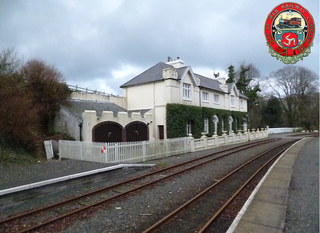
Port Soderick Railway Station is the first station on the Port Erin line of the Isle of Man Railway and is located near the settlement of the same name on the Isle of Man. It forms part of the sole remaining section of the railway which once served a 46-mile network across the island.

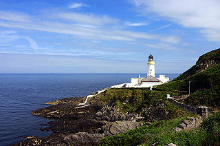
Douglas Head is a rocky point on the Isle of Man overlooking Douglas Bay and harbour. Views extend to include Snaefell Mountain and Laxey.

Baldrine Station is a railway halt in the Isle of Man. It is an intermediate request stop on the east coast route of the Manx Electric Railway in the village of Baldrine in the parish of Lonan, on the route to Ramsey.
Glen Mona Railway Station is an intermediate stopping place on the northerly section of the Manx Electric Railway on the Isle of Man.

Douglas Head Amphitheatre is a structure on the promontory of Douglas Head on the Isle of Man.

Ramsey Station serves the town of Ramsey in the Isle of Man; it is the northern terminus of the Manx Electric Railway. It was formerly known as Ramsey (Plaza) Station after the nearby Plaza cinema, now demolished and turned into a car park. Today it is often also known as Ramsey Tram Station and signage to this effect adorns the station, despite the line being described as a railway. It should not be confused with Ramsey's former station on the Isle of Man Railway.

Gob-Y-DeiganRailway Station was a station on the Manx Northern Railway, later owned and operated by the Isle of Man Railway; it served a beach near Kirk Michael in the Isle of Man and was an intermediate stopping place on a line that ran between St. John's and Ramsey.

The Upper Douglas Cable Tramway was a tram line serving all points between the southern end of the promenade and the upper part of the town of Douglas in the Isle of Man. It opened on 15 August 1896 and closed on 19 August 1929.
Ballabeg Station is a rural intermediate request stop on the coastal route of the Manx Electric Railway on the Isle of Man with a small station house constructed in 1905.

Groudle Glen Station is the first mandatory stopping point and major station on the Manx Electric Railway which serves the village of Groudle Glen in the Isle of Man, and is situated between Groudle Lane and Eskadale on the route to Laxey and Ramsey.

Groudle Lane Halt is a request stop on the Manx Electric Railway on the Isle of Man, located below the line's first summit on the descent into the nearby valley of the same name.
Scarffe's Crossing is a diminutive and little-used request stop on the Manx Electric Railway on the Isle of Man
Ballamenagh Halt is a request stop on the Manx Electric Railway on the Isle of Man.
Ballagawne Halt is a rural request stop on the Manx Electric Railway on the Isle of Man.
Miller's Crossing is a small request stop on outskirts of Laxey on the route of the Manx Electric Railway on the Isle of Man.
Laxey Old Road is a diminutive request-only stop on the northern side of the valley on the climb out of Laxey on the Manx Electric Railway on the Isle of Man, and serves the local community rather than visiting tourists. It, like many of the other small stops on the line established itself over a number of years as a requested stop for local traffic but despite this, and in common with many similar halts, it has never been included on the timetable for any of the line's services. Its location is above an area known locally as "Little Egypt" because it was used as a tipping ground for the ore spoils of the Great Laxey Mines, giving the area the appearance of what looked like pyramids. These spoils have long-since disappeared and the area is a desirable residential area.
There have been five cliff railways in the Isle of Man, none of which remain operational. Usually referred to as 'cliff lifts', they were all railways, having wheeled carriages running on weight-bearing rails. The two Falcon lifts served the same hotel at different periods ; the first Falcon lift was moved to become the Port Soderick lift, at the south end of the Douglas Southern Electric Tramway, with the Douglas Head lift at its north end. The Browside lift served the Laxey Wheel.


