The A Line is a 48.5-mile (78.1 km) light rail line in Los Angeles County, California. It is one of the six lines of the Los Angeles Metro Rail system, operated by the Los Angeles County Metropolitan Transportation Authority (Metro). The A Line serves 44 stations and runs east-west between Azusa and Pasadena, then north-south between Pasadena and Long Beach. It interlines and shares five stations with the E Line in Downtown Los Angeles. Service operates for approximately 19 hours with headways of up to 8 minutes during peak hours. The A Line is currently the longest light rail line in the world.

The E Line is a 22-mile (35 km) light rail line in Los Angeles County, California. It is one of the six lines of the Los Angeles Metro Rail system, operated by the Los Angeles County Metropolitan Transportation Authority (Metro). The E Line runs east-west and serves 29 stations between East Los Angeles and Santa Monica. It interlines and shares five stations with the A Line in Downtown Los Angeles. Service operates for approximately 19 hours with headways of up to 8 minutes during peak hours. The E Line, the second-busiest light rail line in the system, saw an average of 41,902 passengers on weekdays in October 2023.

The C Line is a 19.3-mile (31.1 km) light rail line running between Redondo Beach and Norwalk within Los Angeles County, California. It is one of six lines forming the Los Angeles Metro Rail system and opened on August 12, 1995. Along the route, the line serves the cities of Downey, El Segundo, Hawthorne, Norwalk and Lynwood, the Los Angeles community of Westchester, and several unincorporated communities in the South Los Angeles region including Athens, Del Aire, and Willowbrook. A free shuttle bus to Los Angeles International Airport (LAX) is available at the line's Aviation/LAX station.

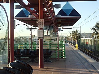
Aviation/LAX station is an elevated light rail station on the C Line of the Los Angeles Metro Rail system. It is located over Aviation Boulevard, after which the station is named, near its intersection with Imperial Highway and south of Century Freeway in Los Angeles, California. It opened as part of the Green Line on August 12, 1995. The station was initially named Aviation Blvd/I-105, but in 2003, it was simplified and renamed Aviation/LAX to highlight its proximity to Los Angeles International Airport.

Willowbrook/Rosa Parks station is a major transport hub and Los Angeles Metro Rail station that serves the A Line and C Line. The station, located at the intersection of Imperial Highway and Wilmington Avenue in the Willowbrook community of Los Angeles County, is a major transfer point for commuters.

Wardlow station is an at-grade light rail station on the A Line of the Los Angeles Metro Rail system. The station is located on the A Line's exclusive right-of-way that parallels Pacific Place, at its intersection with Wardlow Street, after which the station is named, in the Wrigley neighborhood of Long Beach, California.

Lakewood Boulevard station is a below-grade light rail station on the C Line of the Los Angeles Metro Rail system. It is situated in the median of Interstate 105, below Lakewood Boulevard, after which the station is named. The station serves the city of Downey, California and opened as part of the Green Line on August 12, 1995.

Norwalk station is a below-grade light rail station on the C Line of the Los Angeles Metro Rail system. It is located in the median of Interstate 105, below Interstate 605 in the city of Norwalk, California, after which the station is named. It is currently the eastern terminus of the C Line.

Vermont/Athens station is a below-grade light rail station on the C Line of the Los Angeles Metro Rail system. It is situated in the median of Interstate 105 and named after Vermont Avenue and the Athens community where it is located. It opened as part of the Green Line on August 12, 1995.

Crenshaw station is a elevated light rail station on the C Line of the Los Angeles Metro Rail system. It is located in the median of Interstate 105, above Crenshaw Boulevard, after which the station is named. The station is in the city of Hawthorne, California and opened as part of the Green Line on August 12, 1995.
Mariposa station is an elevated light rail station on the C Line of the Los Angeles Metro Rail system. It is located over Mariposa Avenue, after which the station is named, alongside Nash Street in El Segundo, California. It opened with the commencement of Green Line service on August 12, 1995.

El Segundo station is an elevated light rail station on the C Line of the Los Angeles Metro Rail system. It is located over El Segundo Boulevard, after which the station is named, near its intersection with Nash Street in El Segundo, California. It opened with the commencement of Green Line service on August 12, 1995.

Redondo Beach station is an elevated light rail station on the C Line of the Los Angeles Metro Rail system. It is located over Marine Avenue in the city of Redondo Beach, California, after which the station is named. It opened with the commencement of Green Line service on August 12, 1995. The station is currently the western terminus of the C Line. An extension beyond Redondo Beach into Torrance is in the planning stages.

Rosecrans station is a busway station located in Los Angeles, California. It is situated between the Harbor Freeway station and the Harbor Gateway Transit Center on the J Line, a bus rapid transit route which runs between El Monte, Downtown Los Angeles and San Pedro as part of the Metro Busway system. The station consists of two side platforms in the center of Interstate 110 under Rosecrans Avenue. The station serves the Harbor Gateway neighborhoods of Los Angeles.

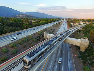
Lake station is a below-grade light rail station on the A Line of the Los Angeles Metro Rail system. It is located in the median of Interstate 210, below North Lake Avenue, after which the station is named, in Pasadena, California. The light rail station opened on July 26, 2003, as part of the original Gold Line, then known as the "Pasadena Metro Blue Line" project.

The K Line is a 5.9-mile (9.5 km) light rail line running north–south between the Jefferson Park and Westchester neighborhoods of Los Angeles, California, passing through various South Los Angeles neighborhoods and the city of Inglewood. It is one of six lines in the Los Angeles Metro Rail system operated by the Los Angeles County Metropolitan Transportation Authority (LACMTA). It opened on October 7, 2022, making it the system's newest line.

Duarte/City of Hope station is an at-grade light rail station on the A Line of the Los Angeles Metro Rail system. It is located at the intersection of Duarte Road and Highland Avenue in Duarte, California, after which the station is named, along with the City of Hope National Medical Center located across the street from the station.

Metro Busway is a system of bus rapid transit (BRT) routes that operate primarily along exclusive or semi-exclusive roadways known locally as a busway or transitway. There are currently two lines serving 29 stations in the system: the G Line in the San Fernando Valley, and the J Line, serving El Monte, Downtown Los Angeles, Gardena, and San Pedro. The Los Angeles County Metropolitan Transportation Authority (Metro) operates the Metro Busway system.

Grand Avenue Arts/Bunker Hill station is an underground light rail station on the A and E lines of the Los Angeles Metro Rail system. The station also has street level stops for the J Line of the Los Angeles Metro Busway system. The station is located under the intersection of 2nd Place and Hope Street, near the Grand Avenue Arts district and in the Bunker Hill neighborhood of Downtown Los Angeles, after which the station is named. In planning documents, the station was originally referred to as 2nd Place/Hope.
The Southeast Gateway Line, formerly the West Santa Ana Branch Transit Corridor, is a planned light rail line, mostly following the Pacific Electric's historic West Santa Ana Branch, connecting Downtown Los Angeles to the city of Artesia, along with other cities in southeastern Los Angeles County.

