Drury, Kansas

Last updated

Drury, Kansas
Stouffer's Railroad Map of Kansas 1915-1918 Sumner County.png
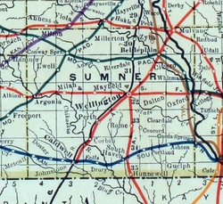
1915 Railroad Map of Sumner County
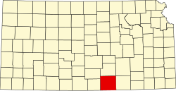
Map of Sumner Co, Ks, USA.png
USA Kansas location map.svg
Red pog.svg
Drury
Usa edcp location map.svg
Red pog.svg
Drury
Coordinates: 37°02′08″N97°28′40″W / 37.03556°N 97.47778°W / 37.03556; -97.47778 [1]
Country United States
State Kansas
County Sumner
Township Falls
Elevation
[1]
1,093 ft (333 m)
Time zone UTC-6 (CST)
  Summer (DST) UTC-5 (CDT)
Area code 620
FIPS code 20-18725
GNIS ID 470077 [1]

Drury is an unincorporated community in Falls Township, Sumner County, Kansas, United States. [1] It is located between South Haven and Caldwell near the intersection of S Drury Rd and W 175th St S, next to the Chikaskia River and next to an abandoned railroad.

Contents

History

Drury was a station and shipping point on the Kansas Southwestern Railway that previously passed through the community, east to west, from South Haven to Caldwell. [2]

Drury had a post office from 1884 until 1921. [3]

The movie Americana was filmed in Drury.

Education

The community is served by Caldwell USD 360 public school district.

Related Research Articles

<span class="mw-page-title-main">Sumner County, Kansas</span> County in Kansas, United States

Sumner County is a county located in the U.S. state of Kansas. Its county seat is Wellington. As of the 2020 census, the population was 22,382. The county is named after Charles Sumner, a U.S. Senator from Massachusetts who was a leader of Reconstruction politics.

<span class="mw-page-title-main">Sedgwick County, Kansas</span> County in Kansas, United States

Sedgwick County is located in the U.S. state of Kansas. Its county seat is Wichita, the most populous city in the state. As of the 2020 census, the population was 523,824, making it the second-most populous county in Kansas. The county was named for John Sedgwick, the highest ranking Union general killed during the American Civil War.

<span class="mw-page-title-main">Butler County, Kansas</span> County in Kansas, United States

Butler County is a county in the U.S. state of Kansas and is the largest county in the state by total area. Its county seat is El Dorado and its most populous city is Andover. As of the 2020 census, the county population was 67,380. The county was named for Andrew Butler, a U.S. Senator from South Carolina who coauthored the Kansas–Nebraska Act.

<span class="mw-page-title-main">Caldwell, Kansas</span> City in Sumner County, Kansas

Caldwell is a city in Sumner County, Kansas, United States. As of the 2020 census, the population of the city was 1,025.

<span class="mw-page-title-main">South Haven, Kansas</span> City in Sumner County, Kansas

South Haven is a city in Sumner County, Kansas, United States. As of the 2020 census, the population of the city was 324.

<span class="mw-page-title-main">Wellington, Kansas</span> City in Sumner County, Kansas

Wellington is a city in and the county seat of Sumner County, Kansas, United States. As of the 2020 census, the population of the city was 7,715.

<span class="mw-page-title-main">Corbin, Kansas</span> Unincorporated community in Sumner County, Kansas

Corbin is an unincorporated community in Sumner County, Kansas, United States. It is located about 6.5 miles northeast of Caldwell near the intersection of S Mayfield Rd and W 110th St S, next to the railroad.

<span class="mw-page-title-main">Peck, Kansas</span> Unincorporated community in Sedgwick and Sumner Counties of Kansas

Peck is an unincorporated community on the Sedgwick and Sumner County border in Kansas, United States. As of the 2020 census, the population of the community and nearby areas was 162. It is located about 2 miles west of the Kansas Star Casino at Meridian Ave and 119th St S, next the Union Pacific Railroad.

<span class="mw-page-title-main">Wichita metropolitan area, Kansas</span> Metropolitan area in the United States

The Wichita, KS Metropolitan Statistical Area, as defined by the United States Office of Management and Budget, is an area consisting of four counties in south central Kansas, it’s only principal city is Wichita and it’s only central county is Sedgwick County. As of the 2013 American Community Survey, the MSA had a population of 637,989.

<span class="mw-page-title-main">Caning of Charles Sumner</span> Attack of US Senator by a Representative

The caning of Charles Sumner, or the Brooks–Sumner Affair, occurred on May 22, 1856, in the United States Senate chamber, when Representative Preston Brooks, a pro-slavery Democrat from South Carolina, used a walking cane to attack Senator Charles Sumner, an abolitionist Republican from Massachusetts. The attack was in retaliation for an invective-laden speech given by Sumner two days earlier in which he fiercely criticized slaveholders, including pro-slavery South Carolina Senator Andrew Butler, a relative of Brooks. The beating nearly killed Sumner and contributed significantly to the country's polarization over the issue of slavery. It has been considered symbolic of the "breakdown of reasoned discourse" and willingness to resort to violence that eventually led to the Civil War.

<span class="mw-page-title-main">Ashton, Kansas</span> Unincorporated community in Sumner County, Kansas

Ashton is an unincorporated community in Walton Township, Sumner County, Kansas, United States. It is located about halfway between South Haven and Arkansas City at 1.75 miles north of the intersection of S Rock Rd and U.S. Route 166, which is 5.5 miles east of I-35, next to an abandoned railroad.

<span class="mw-page-title-main">Dalton, Kansas</span> Unincorporated community in Sumner County, Kansas

Dalton is an unincorporated community in Avon Township, Sumner County, Kansas, United States. It is located about half way between Wellington and Oxford at the intersection of S Oliver Rd and E 15th St S, next to an abandoned railroad.

<span class="mw-page-title-main">Adamsville, Kansas</span> Unincorporated community in Sumner County, Kansas

Adamsville is an unincorporated community in Sumner County, Kansas, United States. It is located about 4 miles north of Geuda Springs at 0.5 mile west of the intersection of S Oxford Rd and E 80th St, next to an abandoned railroad.

<span class="mw-page-title-main">Ewell, Kansas</span> Human settlement in United States of America

Ewell is a ghost town in Sumner County, Kansas, United States. It is located about 3.5 miles southwest of Conway Springs at 0.25 mile southeast of the intersection of N Bluff Rd and W 60th Ave N, next to an abandoned railroad.

<span class="mw-page-title-main">Millerton, Kansas</span> Unincorporated community in Sumner County, Kansas

Millerton is an unincorporated community in Sumner County, Kansas, United States. It is located about 5 miles northeast of Conway Springs at the intersection of N Maple Rd and W 123rd Ave N, next to the railroad.

<span class="mw-page-title-main">Perth, Kansas</span> Unincorporated community in Sumner County, Kansas

Perth is an unincorporated community in Sumner County, Kansas, United States. It is located about 9 miles southwest of Wellington near the intersection of S Clearwater Rd and W 80th St S, next to the railroad.

<span class="mw-page-title-main">Portland, Kansas</span> Unincorporated community in Sumner County, Kansas

Portland is an unincorporated community in Sumner County, Kansas, United States. It is located about 5 miles northeast of South Haven at 1.5 miles north of the intersection of S Hydraulic Rd and U.S. Route 166, next to an abandoned railroad. It is 1.5 miles east of I-35.

<span class="mw-page-title-main">Riverdale, Kansas</span> Unincorporated community in Sumner County, Kansas

Riverdale is an unincorporated community in Sumner County, Kansas, United States. It is located about 6 miles southwest of Belle Plaine at the intersection of N Sand Plum Rd and 77th Ave N, or west of U.S. Route 81 next to the railroad.

<span class="mw-page-title-main">K-49 (Kansas highway)</span> State highway in Kansas

K-49 is a 35.354-mile-long (56.897 km) north–south state highway in the U.S. state of Kansas. K-49 begins at U.S. Route 81 (US-81) in Caldwell, and runs north to K-42 in Viola. Along the way, K-49 has a brief overlap with US-160 south of Conway Springs. The majority of the route exists in Sumner County, with only a mile existing in Sedgwick County.

<span class="mw-page-title-main">Rome, Sumner County, Kansas</span> Unincorporated community in Sumner County, Kansas

Rome is an unincorporated community in Sumner County, Kansas, United States. It is located about 6.5 miles south of Wellington at about 0.5 miles east of the intersection of U.S. Route 81 and E 90th St, next to the railroad.

References

  1. 1 2 3 4 "Drury, Kansas", Geographic Names Information System , United States Geological Survey, United States Department of the Interior
  2. Blackmar, Frank Wilson (1912). Kansas: A Cyclopedia of State History, Embracing Events, Institutions, Industries, Counties, Cities, Towns, Prominent Persons, Etc. Standard Publishing Company. pp.  549.
  3. "Kansas Post Offices, 1828-1961". Kansas Historical Society. Archived from the original on October 9, 2013. Retrieved June 27, 2014.

Further reading