Mulvane, Kansas

Last updated

Mulvane, Kansas
Sedgwick County Kansas Incorporated and Unincorporated areas Mulvane Highlighted.svg
Location within Sedgwick County and Kansas
Map of Sedgwick Co, Ks, USA.png
Coordinates: 37°29′03″N97°14′35″W / 37.48417°N 97.24306°W / 37.48417; -97.24306 [1]
Country United States
State Kansas
Counties Sedgwick, Sumner
Founded1870s
Platted 1879
Incorporated 1883
Named for Joab Mulvane
Government
   Mayor Brent Allen [2]
Area
[3]
  Total4.47 sq mi (11.58 km2)
  Land4.46 sq mi (11.56 km2)
  Water0.01 sq mi (0.02 km2)
Elevation
[1]
1,263 ft (385 m)
Population
 (2020) [4] [5]
  Total6,286
  Density1,400/sq mi (540/km2)
Time zone UTC-6 (CST)
  Summer (DST) UTC-5 (CDT)
ZIP code
67110
Area code 316
FIPS code 20-49100
GNIS ID 2395137 [1]
Website mulvanekansas.com

Mulvane is a city in Sedgwick and Sumner counties in the U.S. state of Kansas. [1] As of the 2020 census, the population of the city was 6,286. [4] [5]

Contents

History

1915 Railroad Map of Sedgwick County Stouffer's Railroad Map of Kansas 1915-1918 Sedgwick County.png
1915 Railroad Map of Sedgwick County

Mulvane was laid out in 1879 [6] [7] at the junction of five Santa Fe rail lines. It is named for Joab R. Mulvane, a railroad official who was instrumental in bringing the Atchison, Topeka, and Santa Fe Railroad to Mulvane. [8]

Mulvane was changed to a city of the second class on December 20, 2001. [7]

In 2008 and 2009, the city annexed land towards the west side of I-35 (Kansas Turnpike), then the Kansas Star Casino opened on it in 2011. [9]

Geography

According to the United States Census Bureau, the city has a total area of 4.52 square miles (11.71 km2), of which, 4.50 square miles (11.65 km2) is land and 0.02 square miles (0.05 km2) is water. [10]

Mulvane's Main Street follows part of the Sedgwick and Sumner county lines, and the town center is about five miles west of the spot where Sedgwick, Sumner, Butler and Cowley counties meet.

Demographics

Historical population
CensusPop.Note
1880 215
1890 724236.7%
1900 667−7.9%
1910 1,08462.5%
1920 1,23914.3%
1930 1,042−15.9%
1940 940−9.8%
1950 1,38747.6%
1960 2,981114.9%
1970 3,1856.8%
1980 4,25433.6%
1990 4,6749.9%
2000 5,15510.3%
2010 6,11118.5%
2020 6,2862.9%
U.S. Decennial Census
2010-2020 [5]

Mulvane is a part of the Wichita, KS Metropolitan Statistical Area.

2020 census

The 2020 United States census counted 6,286 people, 2,338 households, and 1,656 families in Mulvane. [11] [12] The population density was 1,408.8 per square mile (543.9/km2). There were 2,465 housing units at an average density of 552.4 per square mile (213.3/km2). [12] [13] The racial makeup was 89.01% (5,595) white or European American (87.32% non-Hispanic white), 0.48% (30) black or African-American, 1.0% (63) Native American or Alaska Native, 0.62% (39) Asian, 0.11% (7) Pacific Islander or Native Hawaiian, 0.6% (38) from other races, and 8.18% (514) from two or more races. [14] Hispanic or Latino of any race was 4.88% (307) of the population. [15]

Of the 2,338 households, 38.0% had children under the age of 18; 54.6% were married couples living together; 24.5% had a female householder with no spouse or partner present. 24.3% of households consisted of individuals and 11.9% had someone living alone who was 65 years of age or older. [12] The average household size was 2.6 and the average family size was 3.0. [16] The percent of those with a bachelor’s degree or higher was estimated to be 20.8% of the population. [17]

27.8% of the population was under the age of 18, 7.8% from 18 to 24, 25.1% from 25 to 44, 23.2% from 45 to 64, and 16.1% who were 65 years of age or older. The median age was 37.0 years. For every 100 females, there were 107.0 males. [12] For every 100 females ages 18 and older, there were 110.7 males. [12]

The 2016-2020 5-year American Community Survey estimates show that the median household income was $65,286 (with a margin of error of +/- $16,008) and the median family income was $77,835 (+/- $17,261). [18] Males had a median income of $44,233 (+/- $7,691) versus $28,997 (+/- $6,552) for females. The median income for those above 16 years old was $34,413 (+/- $12,361). [19] Approximately, 5.1% of families and 9.2% of the population were below the poverty line, including 14.1% of those under the age of 18 and 2.7% of those ages 65 or over. [20] [21]

2010 census

As of the census [22] of 2010, there were 6,111 people, 2,244 households, and 1,661 families living in the city. [23] The population density was 1,358.0 inhabitants per square mile (524.3/km2). There were 2,357 housing units at an average density of 523.8 per square mile (202.2/km2). The racial makeup of the city was 94.4% White, 0.6% African American, 1.1% Native American, 0.8% Asian, 0.1% Pacific Islander, 0.7% from other races, and 2.4% from two or more races. Hispanic or Latino of any race were 3.5% of the population.

There were 2,244 households, of which 40.4% had children under the age of 18 living with them, 59.3% were married couples living together, 10.5% had a female householder with no husband present, 4.2% had a male householder with no wife present, and 26.0% were non-families. 23.4% of all households were made up of individuals, and 10.5% had someone living alone who was 65 years of age or older. The average household size was 2.70 and the average family size was 3.18.

The median age in the city was 35.1 years. 30.4% of residents were under the age of 18; 6.9% were between the ages of 18 and 24; 25.5% were from 25 to 44; 24.2% were from 45 to 64; and 13.1% were 65 years of age or older. The gender makeup of the city was 48.0% male and 52.0% female.

2000 census

As of the census [24] of 2000, there were 5,155 people, 1,896 households, and 1,444 families living in the city. The population density was 2,261.1 inhabitants per square mile (873.0/km2). There were 1,963 housing units at an average density of 861.0 per square mile (332.4/km2). The racial makeup of the city was 96.39% White, 0.17% African American, 0.99% Native American, 0.29% Asian, 0.06% Pacific Islander, 0.60% from other races, and 1.49% from two or more races. Hispanic or Latino of any race were 2.58% of the population.

There were 1,896 households, of which 41.0% had children under the age of 18 living with them, 63.0% were married couples living together, 9.3% had a female householder with no husband present, and 23.8% were non-families. 21.0% of all households were made up of individuals, and 9.1% had someone living alone who was 65 years of age or older. The average household size was 2.69 and the average family size was 3.14.

In the city, the population was spread out, with 30.4% under the age of 18, 8.4% from 18 to 24, 28.8% from 25 to 44, 20.7% from 45 to 64, and 11.7% were 65 years of age or older. The median age was 34 years. For every 100 females, there were 93.1 males. For every 100 females age 18 and over, there were 89.8 males.

The median income for a household in the city was $46,923, and the median income for a family was $56,285. Males had a median income of $39,732 versus $26,797 for females. The per capita income for the city was $19,523. About 2.1% of families and 3.4% of the population were below the poverty line, including 4.0% of those under age 18 and 1.6% of those age 65 or over.

Area events and attractions

Education

Primary and secondary

The community is served by Mulvane USD 263 public school district. Munson Primary School teaches grades pre-kindergarten through 2nd grade, Mulvane Grade School teaches 3rd grade through 5th grade, Mulvane Middle School teaches 6th grade through 8th grade, and Mulvane High School teaches 9th grade through 12th grade.

Colleges and universities

Cowley County Community College operates a satellite campus within city limits.

Notable people

Related Research Articles

<span class="mw-page-title-main">Garnett, Kansas</span> City in Anderson County, Kansas

Garnett is a city in and the county seat of Anderson County, Kansas, United States. As of the 2020 census, the population of the city was 3,242.

<span class="mw-page-title-main">Muscotah, Kansas</span> City in Kansas, United States

Muscotah is a city in Atchison County, Kansas, United States. As of the 2020 census, the population of the city was 155. Muscotah was named after the Kickapoo Native American word for "prairie".

<span class="mw-page-title-main">Isabel, Kansas</span> City in Kiowa County, Kansas

Isabel is a city in Barber County, Kansas, United States. As of the 2020 census, the population of the city was 68.

<span class="mw-page-title-main">Kiowa, Kansas</span> City in Kiowa County, Kansas

Kiowa is a city in Barber County, Kansas, United States. As of the 2020 census, the population of the city was 902. It is located 1 mile north of the Kansas / Oklahoma state border.

<span class="mw-page-title-main">Benton, Kansas</span> City in Butler County, Kansas

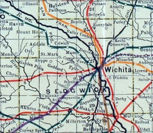
Benton is a city in Butler County, Kansas, United States. As of the 2020 census, the population of the city was 943. It is located northeast of Wichita along K-254 highway.

<span class="mw-page-title-main">McLouth, Kansas</span> City in Kansas, United States

McLouth is a city in Jefferson County, Kansas, United States. As of the 2020 census, the population of the city was 859.

<span class="mw-page-title-main">Randall, Kansas</span> City in Jewell County, Kansas

Randall is a city in Jewell County, Kansas, United States. As of the 2020 census, the population of the city was 79.

<span class="mw-page-title-main">Cunningham, Kansas</span> City in Kingman County, Kansas

Cunningham is a city in Kingman County, Kansas, United States. As of the 2020 census, the population of the city was 444. The city was named in honor of J.D. Cunningham, a pioneer settler.

<span class="mw-page-title-main">Basehor, Kansas</span> City in Kansas, United States

Basehor is a city in Leavenworth County, Kansas, United States which is included statistically in the Kansas City metropolitan area. As of the 2020 census, the population of the city was 6,896.

<span class="mw-page-title-main">Lansing, Kansas</span> City in Kansas, United States

Lansing is a city in Leavenworth County, Kansas, United States. It is situated along the west side of the Missouri River and Kansas-Missouri state border. As of the 2020 census, the population of the city was 11,239. It is the second most populous city of Leavenworth County and is a part of the Kansas City metropolitan area. The Lansing Correctional Facility, which includes the state's main maximum-security prison, is located in Lansing.

<span class="mw-page-title-main">La Cygne, Kansas</span> City in Kansas, United States

La Cygne is a city in Linn County, Kansas, United States, and situated along the Marais des Cygnes River. As of the 2020 census, the population of the city was 1,050. The city is named after the Marais des Cygnes River which is a French translation of an Osage appellation meaning "marsh of the swans".

<span class="mw-page-title-main">Marysville, Kansas</span> City in Marshall County, Kansas

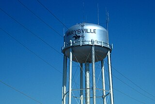
Marysville is a city in and the county seat of Marshall County, Kansas, United States. As of the 2020 census, the population of the city was 3,447.

<span class="mw-page-title-main">Ness City, Kansas</span> City in Ness County, Kansas

Ness City is a city in and the county seat of Ness County, Kansas, United States. As of the 2020 census, the population of the city was 1,329. Ness City is famous for its four-story Old Ness County Bank Building located downtown, and nicknamed Skyscraper of the Plains.

<span class="mw-page-title-main">Norton, Kansas</span> City in Norton County, Kansas

Norton is a city in, and the county seat of, Norton County, Kansas, United States. As of the 2020 census, the population of the city was 2,747.

<span class="mw-page-title-main">Long Island, Kansas</span> City in Phillips County, Kansas

Long Island is a city in Phillips County, Kansas, United States. As of the 2020 census, the population of the city was 137.

<span class="mw-page-title-main">Belleville, Kansas</span> City in Republic County, Kansas

Belleville is a city in and the county seat of Republic County, Kansas, United States. As of the 2020 census, the population of the city was 2,007.

<span class="mw-page-title-main">Gaylord, Kansas</span> City in Smith County, Kansas

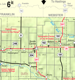
Gaylord is a city in Smith County, Kansas, United States. As of the 2020 census, the population of the city was 87.

<span class="mw-page-title-main">Caldwell, Kansas</span> City in Sumner County, Kansas

Caldwell is a city in Sumner County, Kansas, United States. As of the 2020 census, the population of the city was 1,025.

<span class="mw-page-title-main">Haddam, Kansas</span> City in Washington County, Kansas

Haddam is a city in Washington County, Kansas, United States. It is named after Haddam, Connecticut. As of the 2020 census, the population of the city was 110.

<span class="mw-page-title-main">Lebo, Kansas</span> City in Coffey County, Kansas

Lebo is a city in Coffey County, Kansas, United States. As of the 2020 census, the population of the city was 885.

References

  1. 1 2 3 4 U.S. Geological Survey Geographic Names Information System: Mulvane, Kansas
  2. "Mayor's Office / Mulvane, Kansas". mulvanekansas.com. Retrieved December 27, 2019.
  3. "2019 U.S. Gazetteer Files". United States Census Bureau. Retrieved July 24, 2020.
  4. 1 2 "Profile of Mulvane, Kansas in 2020". United States Census Bureau. Archived from the original on April 4, 2022. Retrieved April 4, 2022.
  5. 1 2 3 "QuickFacts; Mulvane, Kansas; Population, Census, 2020 & 2010". United States Census Bureau. Archived from the original on August 27, 2021. Retrieved August 27, 2021.
  6. Blackmar, Frank Wilson (1912). Kansas: A Cyclopedia of State History, Volume 2. Standard Publishing Company. pp.  332.
  7. 1 2 "History of Mulvane". City of Mulvane. Archived from the original on January 17, 2024.
  8. Bentley, Orsemus Hills (1910). History of Wichita and Sedgwick County, Kansas: Past and Present. Windmill Publications. p. 637.
  9. "Comprehensive Development Plan for the Mulvane Area, Kansas 2013—2023" (PDF). City of Mulvane. 2013. Archived (PDF) from the original on January 17, 2024.
  10. "US Gazetteer files 2010". United States Census Bureau. Archived from the original on January 25, 2012. Retrieved July 6, 2012.
  11. "US Census Bureau, Table P16: HOUSEHOLD TYPE". data.census.gov. Retrieved January 3, 2024.
  12. 1 2 3 4 5 "US Census Bureau, Table DP1: PROFILE OF GENERAL POPULATION AND HOUSING CHARACTERISTICS". data.census.gov. Retrieved January 3, 2024.
  13. Bureau, US Census. "Gazetteer Files". Census.gov. Retrieved December 30, 2023.
  14. "US Census Bureau, Table P1: RACE". data.census.gov. Retrieved January 3, 2024.
  15. "US Census Bureau, Table P2: HISPANIC OR LATINO, AND NOT HISPANIC OR LATINO BY RACE". data.census.gov. Retrieved January 3, 2024.
  16. "US Census Bureau, Table S1101: HOUSEHOLDS AND FAMILIES". data.census.gov. Retrieved January 3, 2024.
  17. "US Census Bureau, Table S1501: EDUCATIONAL ATTAINMENT". data.census.gov. Retrieved January 3, 2024.
  18. "US Census Bureau, Table S1903: MEDIAN INCOME IN THE PAST 12 MONTHS (IN 2020 INFLATION-ADJUSTED DOLLARS)". data.census.gov. Retrieved January 3, 2024.
  19. "US Census Bureau, Table S2001: EARNINGS IN THE PAST 12 MONTHS (IN 2020 INFLATION-ADJUSTED DOLLARS)". data.census.gov. Retrieved January 3, 2024.
  20. "US Census Bureau, Table S1701: POVERTY STATUS IN THE PAST 12 MONTHS". data.census.gov. Retrieved January 3, 2024.
  21. "US Census Bureau, Table S1702: POVERTY STATUS IN THE PAST 12 MONTHS OF FAMILIES". data.census.gov. Retrieved January 3, 2024.
  22. "U.S. Census website". United States Census Bureau . Retrieved July 6, 2012.
  23. "2010 City Population and Housing Occupancy Status". U.S. Census Bureau. Retrieved March 6, 2011.[ dead link ]
  24. "U.S. Census website". United States Census Bureau . Retrieved January 31, 2008.
  25. "Doc Sunback Film Festival Returns With A Look At Wichita Filmmakers". KMUW. June 16, 2021. Retrieved May 2, 2022.

Further reading