
The Port River is part of a tidal estuary located north of the Adelaide city centre in the Australian state of South Australia. It has been used as a shipping channel since the beginning of European settlement of South Australia in 1836, when Colonel Light selected the site to use as a port. Before colonisation, the Port River region and the estuary area were known as Yerta Bulti by the Kaurna people, and used extensively as a source of food and plant materials to fashion artefacts used in daily life.

Osborne is a suburb in the Australian state of South Australia located on the LeFevre Peninsula in the west of Adelaide about 21 kilometres north-west of the Adelaide city centre.

Port Adelaide is a port-side region of Adelaide, approximately 14 kilometres (8.7 mi) northwest of the Adelaide CBD. It is also the namesake of the City of Port Adelaide Enfield council, a suburb, a federal and state electoral division and is the main port for the city of Adelaide. Port Adelaide played an important role in the formative decades of Adelaide and South Australia, with the port being early Adelaide's main supply and information link to the rest of the world. Its Kaurna name, although not officially adopted as a dual name, is Yertabulti.
Outer Harbor is a suburb in the Australian state of South Australia located at the northern tip of the Lefevre Peninsula about 22 kilometres (14 mi) north-west of the Adelaide city centre.

North Haven is a north-western suburb of Adelaide, in the state of South Australia, Australia. It is located 20km from the Central Business District (CBD), and falls under the City of Port Adelaide Enfield. It is adjacent to Osborne and Outer Harbour. It is bounded to the north and east by Oliver Rogers and Victoria Road, to the south by Marmora Terrace and to the west by Gulf St Vincent. The postal code for North Haven is 5018.
The Lefevre Peninsula is a peninsula located in the Australian state of South Australia located about 15 kilometres (9.3 mi) northwest of the Adelaide city centre. It is a narrow sand spit of about 30 square kilometres (12 sq mi) running north from its connection to the mainland.
The Barker Inlet is a tidal inlet of the Gulf St Vincent in Adelaide, South Australia, named after Captain Collet Barker who first sighted it in 1831. It contains one of the southernmost mangrove forests in the world, a dolphin sanctuary, seagrass meadows and is an important fish and shellfish breeding ground. The inlet separates Torrens Island and Garden Island from the mainland to the east, and is characterised by a network of tidal creeks, artificially deepened channels, and wide mudflats. The extensive belt of mangroves are bordered by samphire saltmarsh flats and low-lying sand dunes.

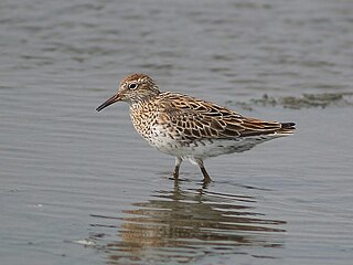
St Kilda is a coastal township, now classed as a suburb, 21 kilometres north-north-west of the centre of Adelaide, capital city of South Australia. With a population below 100 and a sole 4-kilometre (2.5-mile) road connecting to the nearest highway, its natural and built resources have remained relatively undisturbed. The seafront, containing a large area of mangroves, faces the Barker Inlet, which is part of the Port River estuarine area. St Kilda is an internationally recognised bird-watching area: more than 100 species of birds feed in and around the mudflats, salt lagoons, mangroves and seagrass beds.

Price is a town and locality on Yorke Peninsula in South Australia. It is within the Yorke Peninsula Council local government area and is 131 kilometres (81 mi) north west of the centre of state capital, Adelaide.
Bolivar is an outer northern suburb of Adelaide, South Australia. It is located in the City of Salisbury.
The Gulf St Vincent Important Bird Area comprises land extending along the coast of Gulf St Vincent, north of Adelaide, South Australia.
W. H. Burford and Sons was a soap and candle-making business founded in Adelaide in 1840 by William Henville Burford (1807–1895), an English butcher who arrived in the new colony in 1838. It was one of the earliest soapmakers in Australia, and up to the 1960s when it closed, the oldest. In 1878 he took his two sons Benjamin and William into partnership as W. H. Burford & Sons. Its expansion, accompanied by a number of takeovers, made it the dominant soap manufacturer in South Australia and Western Australia. Its founders were noted public figures in the young city of Adelaide.

Dry Creek or Dry Creek Drain is a seasonal stream in South Australia which passes through the Adelaide suburbs of Wynn Vale, Modbury, Walkley Heights and Pooraka. The nearby suburb of Dry Creek and Dry Creek railway station are named after the stream.

Clinton Conservation Park, formerly the Clinton National Park, is a protected area in the Australian state of South Australia located on the coastline at the north end of Gulf St Vincent.

The Adelaide International Bird Sanctuary National Park is a protected area in South Australia established by the South Australian government on the northeast coast of Gulf St Vincent, between Parham in the north and the southern end of Barker Inlet in the south. Its purpose is to rehabilitate land used as salt pans, protect habitat for international migratory shorebirds, manage water quality in adjoining parts of Gulf St Vincent, create "green" space, develop niche tourism and create opportunities for indigenous people.

The Dry Creek explosives depot was a secure storage facility at Dry Creek, near Port Adelaide, from 1904 to 1995, serving the construction, mining and quarrying industries of South Australia and the mines of Broken Hill in New South Wales.

The Hundred of Port Adelaide is a cadastral hundred covering the vicinity of Port Adelaide, Lefevre Peninsula and the coast of the central Adelaide Plains south of Gawler River and west of Port Wakefield Road. It is one of the eleven hundreds of the County of Adelaide and was named in 1846 by Governor Frederick Robe.
Garden Island is an island in the Australian state of South Australia located about 14 kilometres (8.7 mi) north-west of the capital city of Adelaide in an estuary system within the Adelaide metropolitan area which drains into Gulf St Vincent. It is notable as being a site for a mangrove forest, a landfill, a part of the site for the Multifunction Polis, a ship graveyard and a venue for recreational boating activities. It has enjoyed varying degrees of protected area status since 1973.
Barker Inlet – St Kilda Aquatic Reserve is a marine protected area in the Australian state of South Australia located in waters adjoining the east coast of Gulf St Vincent in Barker Inlet about 16 kilometres (9.9 mi) north of the state capital of Adelaide.
The St Kilda saltfields brine spill is an ongoing environmental disaster occurring in St Kilda, South Australia. Former salt production ponds are leaking brine into adjacent wetlands causing death and distress to mangroves, the salt marsh and intertidal ecological communities of Barker Inlet.


