Dumfries-Triangle, Virginia

Last updated

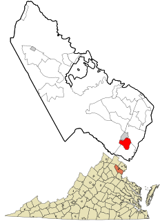
Dumfries-Triangle was a census-designated place (then termed an unincorporated place) in Prince William County, Virginia, United States. Its first and only designation was at the 1950 United States Census and consisted of the unincorporated communities of Dumfries and Triangle. It had a population of 1,585. [1] Dumfries-Triangle was deleted at the 1960 Census as Dumfries and Triangle were designated separately. As of the 2010 Census Dumfries and Triangle collectively have a population of 13,149.

A census-designated place (CDP) is a concentration of population defined by the United States Census Bureau for statistical purposes only. CDPs have been used in each decennial census since 1980 as the counterparts of incorporated places, such as self-governing cities, towns, and villages, for the purposes of gathering and correlating statistical data. CDPs are populated areas that generally include one officially designated but currently unincorporated small community, for which the CDP is named, plus surrounding inhabited countryside of varying dimensions and, occasionally, other, smaller unincorporated communities as well. CDPs include small rural communities, colonias located along the U.S. border with Mexico, and unincorporated resort and retirement communities and their environs.

Prince William County, Virginia County in the United States

Prince William County is a county on the Potomac River in the Commonwealth of Virginia in the United States. As of the 2010 census, the population was 402,002, on July 1, 2015, the population was estimated to be 451,721, making it Virginia's second-most populous county. Its county seat is the independent city of Manassas.

Virginia State of the United States of America

Virginia, officially the Commonwealth of Virginia, is a state in the Southeastern and Mid-Atlantic regions of the United States located between the Atlantic Coast and the Appalachian Mountains. Virginia is nicknamed the "Old Dominion" due to its status as the first English colonial possession established in mainland North America and "Mother of Presidents" because eight U.S. presidents were born there, more than any other state. The geography and climate of the Commonwealth are shaped by the Blue Ridge Mountains and the Chesapeake Bay, which provide habitat for much of its flora and fauna. The capital of the Commonwealth is Richmond; Virginia Beach is the most populous city, and Fairfax County is the most populous political subdivision. The Commonwealth's estimated population as of 2018 is over 8.5 million.

Related Research Articles

Chickaloon, Alaska CDP in Alaska, United States

Chickaloon is a census-designated place (CDP) in Matanuska-Susitna Borough, Alaska, United States. It is part of the Anchorage, Alaska Metropolitan Statistical Area. The population was 272 at the 2010 census, up from 213 in 2000.

Beulah Valley, Colorado CDP in State of Colorado, United States

For unincorporated town see Beulah, Colorado

Clover Hill, Maryland Unincorporated community in Maryland

Clover Hill is an unincorporated community and former census-designated place (CDP) in Frederick County, Maryland, United States. The population was 3,260 at the 2000 census. The area was not listed as a CDP for the 2010 census, and no population total was published.

Brookmont, Maryland census-designated place in Maryland, United States

Brookmont is a census-designated place and an unincorporated area in Montgomery County, Maryland, United States. Brookmont is often considered part of neighboring Bethesda because it falls within Bethesda's 20816 zip code.

Cabin John, Maryland census-designated place in Maryland, United States

Cabin John is a census-designated place and an unincorporated area in Montgomery County, Maryland, United States.

North Kensington, Maryland census-designated place in Maryland, United States

North Kensington is a census-designated place and an unincorporated area in Montgomery County, Maryland, United States.

Redland, Maryland census-designated place in Maryland, United States

Redland is a census-designated place and an unincorporated area in Montgomery County, Maryland, United States.

Rebersburg, Pennsylvania Census-designated place in Pennsylvania, United States

Rebersburg is an unincorporated community and census-designated place (CDP) in Centre County, Pennsylvania, United States. It is part of the State College, Pennsylvania Metropolitan Statistical Area. The official town Mayor is Mr. Matthew Scott Dunlap(Republican) age 27. The population was 494 at the 2010 census and includes many Amish in the area.

Pimmit Hills, Virginia Census-designated place in Virginia, United States

Pimmit Hills is a census-designated place (CDP) in Fairfax County, Virginia, United States. The population was 6,094 at the 2010 census. In practical terms, it is more of a neighborhood within a densely populated urban area than a traditional town.

Dumfries, Virginia Town in Virginia

Dumfries, officially the Town of Dumfries, is a town in Prince William County, Virginia. The population was 4,961 at the 2010 United States Census.

Triangle, Virginia Census-designated place in Virginia, United States

Triangle is a census-designated place (CDP) in Prince William County, Virginia, United States. The population was 8,188 at the 2010 census. It is bounded to the south by the Marine Corps Base Quantico, which surrounds the town of Quantico.

Chevy Chase (CDP), Maryland Census-designated place in Maryland, United States

Chevy Chase is a census-designated place (CDP) in Montgomery County, Maryland. The population was 9,381 at the 2000 census.

Brandon, Colorado Census-designated place in State of Colorado, United States

Brandon is an unincorporated community and census-designated place in Kiowa County, Colorado, United States. The population as of the 2010 census was 21. The U.S. Post Office at Sheridan Lake now serves Brandon postal addresses.

Emison, Indiana Census-designated place in Indiana, United States

Emison is an unincorporated community and census-designated place (CDP) in Busseron Township, Knox County, Indiana. Its population was 154 at the 2010 census.

Benedict-Leona Mines was a census-designated place in Lee County, Virginia, United States. Its first and only designation was at the 1950 United States Census when it had a population of 1,486. Benedict-Leona Mines did not reappear at subsequent censuses.

Loudoun Valley Estates, Virginia census designated place

Loudoun Valley Estates is a census-designated place (CDP) in Loudoun County, Virginia. The population as of the 2010 United States Census was 3,656. It is a Toll Brothers community located near the planned Ashburn metro station complex and Moorefield Station town center in Ashburn, VA.

Moorefield Station, Virginia human settlement in United States of America

Moorefield Station is a census-designated place (CDP) in Loudoun County, Virginia. The population as of the 2010 United States Census was 77. Moorefield Station is a mixed-use development currently in progress, located at the planned terminus of the Metrorail Silver Line.

Peak Place, New Mexico Unincorporated community in New Mexico, United States

Peak Place is an unincorporated community and census-designated place in Santa Fe County, New Mexico, United States. Its population was 377 as of the 2010 census.

Pueblito, New Mexico Census-designated place in New Mexico, United States

Pueblito is an unincorporated community and census-designated place in Rio Arriba County, New Mexico, United States. Its population was 91 as of the 2010 census.

References

  1. "1950 Census of Population." U.S. Census Bureau. Retrieved on August 17, 2010.

Coordinates: 38°33′28″N77°19′32″W / 38.557830°N 77.325468°W / 38.557830; -77.325468

Geographic coordinate system Coordinate system

A geographic coordinate system is a coordinate system that enables every location on Earth to be specified by a set of numbers, letters or symbols. The coordinates are often chosen such that one of the numbers represents a vertical position and two or three of the numbers represent a horizontal position; alternatively, a geographic position may be expressed in a combined three-dimensional Cartesian vector. A common choice of coordinates is latitude, longitude and elevation. To specify a location on a plane requires a map projection.