Dumka, the headquarters of the Dumka district and Santhal Pargana region, is a city in the state of Jharkhand, India. It was made the headquarters of the Santhal Pargana region, which was carved out of the Bhagalpur and Birbhum district after the Santal Hool of 1855. Dumka was carved out of the southern part of Bihar along with 18 other districts on 15 November 2000 to form Jharkhand as the 28th state of India. Dumka is a peaceful and green city and also the sub-capital of Jharkhand. The nearest important cities are Suri and Deoghar.
There are two theories on how Dumka got its name. The first one suggests that Dumka's name derives from the Santali word sumk for "shunted" or "small," because during the British Raj, it was a small town compared to Rampurhat and Bhagalpur.
The other is that Dumka derives its name from the Persian word damin-i-koh, which means 'skirts (an edge, border or extreme part) of the hills'.
History
Early history
The earlier inhabitants of the present-day district of whom there is some record, it appears, were the Paharias (for example, the Maler and Sauria Paharias). The Greek traveler Megasthenes identified these people as Mallis. He referred to the Sauria Paharias as savars[what language is this?] of Odisha. Medieval History: Due to inaccessibility of the area caused by the cliffs of the Rajmahal Hills, it was a place of strategic economic importance, with a fort at Teliagarhi. After the 1539 victory of Sher Shah Suri at Chousa, the area fell into the hands of the Afghans, but it was soon lost to the Mughals under Akbar when Hussain Quli Khan was made viceroy of Bengal.
British Raj
The English representative, Dr. Gabriel Bokgliton, procured a firman from Shah Jahan. Between 1742 and 1751 the area of Dumka close to Rajmahal witnessed frequent inroads by the Marathas under Raghoji Bhosle and Peshwa Balaji Rao. In 1745 Raghoji Bhosle entered Rajmahal via the hills and jungles of Santhal Pargana Division. The early stay of the English was spent in subduing the Paharias. In 1769 Dumka remained a Ghatwali police post under Birbhum District of Bengal. In 1775 Dumka was transferred to Bhagalpur Division. In 1865 Dumka was made an independent district after being carved out of Bhagalpur. In 1872 Dumka was made headquarters of the whole district of Santal Pargana. In 1889 Paul Olaf Bodding started his service in India (Dumka/Benagaria) after Lars Olsen Skrefsrud, and Bodding created the first alphabet for the Santhals. The NELC-church was created as a Lutheran Church in this area - before the Catholics had established a mission in this area at all. In 1902 the first municipality was established. Finally in 1920 Motor cars and buses were introduced.
Post Independence
Firstly in 1952 The Apostolic Prefecture of Malda was erected. In 1962, it was promoted to the Roman Catholic Diocese of Dumka. Then in 1983 Dumka was made the divisional headquarters of Santhal Pargana. On 15 November 2000 Dumka became the sub-capital of Jharkhand. In 2011 Dumka is connected with the newly built Jasidih-Dumka railway line. In 2012 Intercity express to Ranchi started via Jasidih. Later in 2017 Jharkhand opens pilot training center in Dumka. Finally in 2018 Four-lane road from Dudhani to Tata Showroom constructed.
Geography
16km 9.9miles
B
I
H
A
R
W
E
S
T
B
E
N
G
A
L
l
Mayurakshi River
k
Ajay River
j
Barakar River
D
Massanjore Dam
CT
Rasikpur
CT
Purana Dumka
CT
Dudhani
CT
Karmatanr
M
Mihijam
M
Jamtara
M
Basukinath
M
Dumka
M
Madhupur
M
Jasidih
M
Deoghar
R
Narayanpur
R
Nala
R
Kundahit
R
Fatehpur
R
Bindapathar
R
Basudih
R
Bagdahari
R
Tongra
R
Taljhari
R
Shikaripara
R
Saraiyahat
R
Ranishwar
R
Ramgarh
R
Masalia
R
Maluti
R
Kathikund
R
Jarmundi
R
Jama
R
Hansdiha
R
Gopikandar
R
Sarwan
R
Sarath
R
Palojori
R
Mohanpur
R
Margomunda
R
Karon
R
Devipur
R
Sonaraithari
R
Chitra
Cities, towns and locations in the Deoghar, Dumka and Jamtara districts in Santhal Pargana Division M: Municipality, CT: census town, R: Rural/ Urban centre, D: Dam, Owing to space constraints in the small map, the actual locations in a larger map may vary slightly
As of 2011[update] India census,[4] Dumka is a Nagar Parishad city in district of Dumka, Jharkhand. The Dumka city is divided into 23 wards for which elections are held every five years. The Dumka Nagar Parishad has population of 47,584 of which 25,364 are males while 22,220 are females as per report released by Census India 2011.
The population of children aged 0-6 is 5371 which is 11.29% of total population of Dumka (Nagar Parishad). In Dumka Nagar Parishad, the female sex ratio is 876 against state average of 948. Moreover, the child sex ratio in Dumka is around 891 compared to Jharkhand state average of 948. The literacy rate of Dumka city is 89.92% higher than the state average of 66.41%. In Dumka, male literacy is around 93.46% while the female literacy rate is 85.87%. As per official census 2011, Hinduism constitutes 79.06% of Dumka's population, followed by Islam at 8.09% and Christianity with 6.54%.
Religion and Languages
Religion in Dumka (2011)
Religion
Percent
Hinduism
88.25%
Islam
8.46%
Christianity
2.70%
Jainism
0.04%
Others†
0.14%
Distribution of religions
†Includes Sikhism (0.06%), Buddhism (0.08%).
†† Follwers of Sari Dharam and Sarna are also covered under Hinduism owing to devoid of centrally recognized regious code.
Besides the national official language Hindi, Santali, Urdu and Bengali are mostly spoken followed by regional dialect Khorta.
Estimated Avg. No. of daily Worker Employed in small scale industries
No.
38
5
Employment in large and medium Industries
No.
NIL
6
No of Industrial Area
No.
1
Culture
Dumka District contains many Hindu temples, such as Basukinath, Sirshanath, Maluti Mandir, Shiv Pahar and Dharamsthana. Crowds visit these places during the month of Sawan.[citation needed] Hizla Mela (Fair)[7] is organized every year in Hizla and continues for a week. It is a fair of great cultural importance, thousands of people visit during the fair.
Politics
The first Chief Minister of Jharkhand, Babulal Marandi, hailed from Dumka constituency. In 2000, when Jharkhand was carved out of Bihar, NDA came to power in Jharkhand with Marandi as the Chief Minister.
Shibu Soren is another politician who is considered to be one of the founders of Jharkhand Mukti Morcha (JMM) and has a temporary residence in Dumka. Hemant Soren, the current Chief Minister of Jharkhand is the son of Shibu Soren.
Education
There are various Higher Secondary schools in Dumka:
Other schools include Ananda Marg School (Kurwa), Modern Sainik School, Green Mount Academy and New Life Academy at Kathikund.
To improve academic performance in government schools District administration of Dumka launched Sampurna Shiksha Kavach[10] for students of grade 9 to grade 12 in following schools:
+2 HS KATHIKUND
+2 HS MASALIYA
+2 HS JAMA
RANI SONAWATI HS
EKALAVYA MODEL RES. SCH KATIJORIA
+2 OBC RES. GIRLS HS
CM School of Excellence Girls, Dumka
+2 UHS BUNIYADI GANDO
PLUS 2 ST HS INDERWANI
+2 RK HS SARAIYHAT
+2 HS RAGHUNATHPUR
+2 UHS TALJHARI
+2 HS BENAGARIA
+2 HS THARIHAT KUSIAM
+2 UHS CHAPAKANDAR
KGBV KATHIKUND
+2 UHS MOHANPUR
KGBV SARAIYAHAT
KGBV JAMA
+2 RK HS SHIKARIPARA
NATIONAL SCHOOL DUMKA
MODEL SCHOOL MASALIYA
MODEL SCHOOL SARAIYAHAT
+2 HS SAHARA
+2 RK HS JARMUNDI
MODEL SCHOOL SHIKARIPARA
+2 UHS PINDARI
DISTRICT CM SCHOOL OF EXCELLENCE, DUMKA
This program focuses on improving performance of students across above 28 government schools in the district. Teachers need to ensure that entire curriculum is covered in classroom via online teaching during the academic year. Students also have additional online learning support after school. High performing students are enrolled in additional classes to prepare for competitive exams such as IIT JEE and NEET.
For higher education Dumka offers many colleges e.g.- Sido Kanhu Murmu University was established in 1992 at Dumka and covers whole Santhal Pargana. Many colleges are affiliated or constituent to SKMU in the division.
St. Xavier's College, Dumka offers various courses. Others include Santhal Pargana College (S.P. college),[11] A.N. College,[12] and S.P. Mahila College, which offer undergraduate, graduate and post-graduate courses.
GTRTC, Dumka (Government Tool Room and Training Centre) was established in 2007 by the Department of Industries, Government of Jharkahnd with the assistance of Ministry of MSME, Government of India.[14] It offers various training programmes to meet need for technical manpower required in the manufacturing sector. Lahanti Institute of Multiple Skills was established by Evangelical Social Action Forum to provide skills training to unemployed youth in the remote regions of Santhal Pargana.[15] Dumka also have a Govt. Polytechnic College, a Govt. Women's Polytechnic College and also a govt. ITI for technical education.
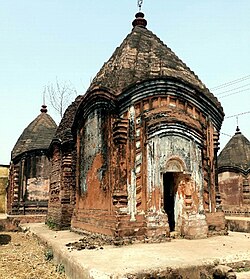
Maluti temple Village - Maluti is an ancient temple village of Dumka District under Shikaripara police station. It is near the border of West Bengal and Jharkhand State. There are many Shiva, Bishnu, Durga Terracotta temples.
Masanjore is a picnic spot situated 30km to Dumka. This small village is about 30km south of Dumka. The Masanjore dam on the Mayurakshi River is a tourist draw.[18] From the counterpart rupee fund created through supplies of wheat and other materials from Canada for use in India, Canada Govt. devoted those funds to further development of the Mayurakshi project and Massanjore Dam was commissioned in 1955. The Dam is still mentioned as Canada Dam. The dam is bounded by hills and forests. Mayurakshi Bhawan Bungalow and Inspection Bungalow, offer accommodation within the village.[19] By road, Masanjore is connected with Vakreshwara (59km), Sainthia (50km), Tarapith (70km), Rampurhat (62km) and Deoghar (98km).
Chutonath - It is situated 20km from the district headquarters. Chutonath is a religious place of Hindu god Lord Chutonath. This festival is celebrated mainly in the month of April. This area has become a tourist attraction.[20]
Dharmasthan - It is temple situated in Tin bazaar at the heart of Dumka Town, it is known for the Goddess Kali, during the Durga puja 7 days special puja is organised here.
Natural places
Kurwa park (Shrishti Pahar) - It is a small picnic spot about 5km to the east of Dumka. It has a park, facilities for boating and a small hill. A temple is also situated here.
In July 2011, Dumka was connected to Jasidih with the newly built Jasidih - Dumka railway line. Since then, the city has seen a growing number of three-wheelers on the road. in June 2015, Dumka Rampurhat Train service is also started.
Road
Dumka is connected by road to the neighboring cities such as Deoghar, Bhagalpur, Dhanbad, Rampurhat. Buses are the preferred mode of transport and are run by both government agencies and private operators. Dumka has good connectivity to neighboring districts with buses. There is a luxury night bus service between Dumka–Ranchi and Kolkata.[18]
This page is based on this Wikipedia article Text is available under the CC BY-SA 4.0 license; additional terms may apply. Images, videos and audio are available under their respective licenses.