Pakur district

Last updated

Pakur district
Stone crushing unit in Pakur.jpg
A stone-quarrying unit in Pakur district
Pakur in Jharkhand (India).svg
Location of Pakur district in Jharkhand
CountryFlag of India.svg  India
State Government banner of Jharkhand.png Jharkhand
Division Santhal Pargana
Headquarters Pakur
Government
   Lok Sabha constituencies Rajmahal (shared with Sahebganj district)
   Vidhan Sabha constituencies 3
Area
  Total1,805.59 km2 (697.14 sq mi)
Population
 (2011) [1]
  Total900,422
  Density500/km2 (1,300/sq mi)
   Urban
5.13%
Demographics
   Literacy 50.17 per cent
  Sex ratio989
Time zone UTC+05:30 (IST)
Website pakur.nic.in

Pakur district is one of the twenty-four districts of Jharkhand state, India, and Pakur is the administrative headquarters of this district. Pakur sub-division of Sahibganj district was carved out on 28 January 1994 to constitute Pakur District. The district, with a population of 900,422 (census 2011), and covering an area of 686.21 km2, is situated on the north-eastern corner of Jharkhand state.

Contents

Geography

The district is bounded on the north by Sahibganj district, on the south by Dumka district, on the west by Godda district, and on the east by Birbhum and Murshidabad districts of West Bengal. [2] The west of the district contains the Rajmahal Hills, while the east of the district is mostly flat plain.

Economy

It is famous for its Black stone. It is generating the highest revenue for Howrah railway Division by supplying Black Stone Chips across India and Coal to Punjab.

In the past, Pakur was a land populated by Santhals and Mal Paharia people. However, over a period of time, demographic composition has gradually changed to the modern era, and the local folks have come to the mainstream of the Indian society.

In 2006 the Ministry of Panchayati Raj named Pakur one of the country's 250 most backward districts (out of a total of 640). [3] It is one of the 21 districts in Jharkhand currently receiving funds from the Backward Regions Grant Fund Programme (BRGF). [3]

Administration

Blocks/Mandals

Pakur district consists of six community development blocks. The following are the list of the blocks in the Pakur district:

Demographics

Historical population
YearPop.±% p.a.
1901215,587    
1911224,304+0.40%
1921214,299−0.46%
1931244,945+1.35%
1941266,956+0.86%
1951277,421+0.39%
1961347,012+2.26%
1971403,078+1.51%
1981464,154+1.42%
1991564,253+1.97%
2001701,664+2.20%
2011900,422+2.53%
source: [4]
Religions in Pakur district (2011) [5]
ReligionPercent
Hinduism
45.55%
Islam
35.87%
Sarna
9.86%
Christianity
8.43%
Other or not stated
0.29%

According to the 2011 census Pakur district has a population of 900,422, [1] roughly equal to the nation of Fiji [6] or the US state of Delaware. [7] This gives it a ranking of 465th in India (out of a total of 640). [1] The district has a population density of 498 inhabitants per square kilometre (1,290/sq mi) . [1] Its population growth rate over the decade 2001-2011 was 28.15%. [1] Pakur has a sex ratio of 985 females for every 1000 males, [1] and a literacy rate of 50.17%. 7.50% of the population lives in ruban areas. Scheduled Castes and Scheduled Tribes make up 3.16% and 42.10% of the population respectively. [1]

Languages of Pakur district (2011) [8]

   Bengali (39.42%)
   Santali (36.40%)
   Khortha (11.84%)
   Malto (4.90%)
   Hindi (2.83%)
   Urdu (1.77%)
   Bhojpuri (1.66%)
  Others (1.18%)

At the time of the 2011 Census of India, 39.42% of the population in the district spoke Bengali, 36.40% Santali, 11.84% Khortha, 4.90% Malto, 2.83% Hindi, 1.77% Urdu and 1.66% Bhojpuri as their first language. [8]

Villages

See also

Related Research Articles

<span class="mw-page-title-main">Godda district</span> District of Jharkhand in India

Godda district is one of the twenty-four districts of Jharkhand state in eastern India It lies in the northeastern part of the state. The geographical area that now comprises Godda district used to be part of the erstwhile Santhal Parganas district. Godda town is the headquarters of Godda district. The area of the district is 2110 km², with a population of around 1,313,551.

<span class="mw-page-title-main">Simdega district</span> District of Jharkhand in India

Simdega district is one of the twenty-four districts of Jharkhand state, India, and Simdega town is the administrative headquarters of this district. This district is the least population density district of jharkhand(2011).This district was carved out from erstwhile Gumla district on 30 April 2001. It is currently a part of the Red Corridor. As of 2011 it is the third least populous district of Jharkhand, after Lohardaga and Khunti districts.

<span class="mw-page-title-main">Sahebganj district</span> District of Jharkhand in India

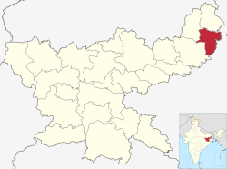
Sahibganj district is one of the twenty-four districts of Jharkhand state, India, and Sahibganj is the administrative headquarters of this district.

<span class="mw-page-title-main">Jamtara district</span> District of Jharkhand in India

Jamtara district is one of the twenty-four districts of Jharkhand state in eastern India. Jamtara town is the administrative headquarters of this district. The district is situated between 23°10′ and 24°05′ north latitudes and 86°30′ and 87°15′ east longitudes.

<span class="mw-page-title-main">Dumka district</span> District of Jharkhand in India

Dumka district is one of the twenty-four districts of Jharkhand state in eastern India. Dumka is the administrative headquarters of this district. This district covers an area of 3716.02 km2. This district has a population of 1,321,442.

Pakur is a community development block that forms an administrative division in the Pakur subdivision of the Pakur district, Jharkhand state, India.

Hiranpur is a community development block that forms an administrative division in the Pakur subdivision of the Pakur district, Jharkhand state, India.

Littipara is a community development block that forms an administrative division in the Pakur subdivision of the Pakur district, Jharkhand state, India.

Amrapara is a community development block that forms an administrative division in the Pakur subdivision of the Pakur district, Jharkhand state, India.

Pakuria is a community development block that forms an administrative division in the Pakur subdivision of the Pakur district, Jharkhand state, India.

Maheshpur is a community development block that forms an administrative division in the Pakur subdivision of the Pakur district, Jharkhand state, India.

Sahibganj is a community development block that forms an administrative division in the Sahibganj subdivision of the Sahibganj district, Jharkhand state, India.

Mandro is a community development block that forms an administrative division in the Sahibganj subdivision of the Sahibganj district, Jharkhand state, India.

Borio is a community development block that forms an administrative division in the Sahibganj subdivision of the Sahibganj district, Jharkhand state, India.

Barhait is a community development block that forms an administrative division in the Sahibganj subdivision of the Sahibganj district, Jharkhand state, India.

Taljhari is a community development block that forms an administrative division in the Rajmahal subdivision of the Sahibganj district, Jharkhand state, India.

Rajmahal is a community development block that forms an administrative division in the Rajmahal subdivision of the Sahibganj district, Jharkhand state, India.

Udhwa is a community development block that forms an administrative division in the Rajmahal subdivision of the Sahibganj district, Jharkhand state, India.

Pathna is a community development block that forms an administrative division in the Rajmahal subdivision of the Sahibganj district, Jharkhand state, India.

Barharwa is a community development block that forms an administrative division in the Rajmahal subdivision of the Sahibganj district, Jharkhand state, India.

References

  1. 1 2 3 4 5 6 7 "District Census Handbook: Pakur" (PDF). Census of India . Registrar General and Census Commissioner of India.
  2. "Profile". Archived from the original on 12 July 2014. Retrieved 10 May 2012.
  3. 1 2 Ministry of Panchayati Raj (8 September 2009). "A Note on the Backward Regions Grant Fund Programme" (PDF). National Institute of Rural Development. Archived from the original (PDF) on 5 April 2012. Retrieved 27 September 2011.
  4. "Table A-02 Decadal Variation in Population Since 1901: Jharkhand" (PDF). census.gov.in. Registrar General and Census Commissioner of India.
  5. "Table C-01 Population By Religion: Jharkhand". census.gov.in. Registrar General and Census Commissioner of India.
  6. US Directorate of Intelligence. "Country Comparison:Population". Archived from the original on 13 June 2007. Retrieved 1 October 2011. Fiji 883,125 July 2011 est.
  7. "2010 Resident Population Data". U. S. Census Bureau. Retrieved 30 September 2011. Delaware 897,934
  8. 1 2 "Table C-16 Population by Mother Tongue: Jharkhand". censusindia.gov.in. Registrar General and Census Commissioner of India.

24°37′48″N87°51′00″E / 24.63000°N 87.85000°E / 24.63000; 87.85000

Politics

|}

DistrictNo.ConstituencyNamePartyAllianceRemarks
Pakur 4 Litipara Dinesh William Marandi Jharkhand Mukti Morcha UPA
5 Pakur Alamgir Alam Indian National Congress UPA Cabinet Minister (Parliamentary Affairs, Rural development)
6 Maheshpur Stephen Marandi Jharkhand Mukti Morcha UPA