
An Earth observation satellite or Earth remote sensing satellite is a satellite used or designed for Earth observation (EO) from orbit, including spy satellites and similar ones intended for non-military uses such as environmental monitoring, meteorology, cartography and others. The most common type are Earth imaging satellites, that take satellite images, analogous to aerial photographs; some EO satellites may perform remote sensing without forming pictures, such as in GNSS radio occultation.

Israel Aerospace Industries, is Israel's major aerospace and aviation manufacturer, producing aerial and astronautic systems for both military and civilian usage. It has 14,000 employees as of 2021. IAI is state-owned by the government of Israel.

Satellite images are images of Earth collected by imaging satellites operated by governments and businesses around the world. Satellite imaging companies sell images by licensing them to governments and businesses such as Apple Maps and Google Maps.
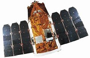
Earth Resources Observation Satellite (EROS) is a series of Israeli commercial Earth observation satellites, designed and manufactured by Israel Aircraft Industries (IAI), with optical payload supplied by El-Op. The satellites are owned and operated by ImageSat International N.V. (ISI), a company founded in 1997, as a Joint venture between IAI, El-Op and Core Software Technology (CST). EROS A was launched on December 5, 2000 and EROS B on April 25, 2006.
The Disaster Monitoring Constellation for International Imaging (DMCii) or just Disaster Monitoring Constellation (DMC) consists of a number of remote sensing satellites constructed by Surrey Satellite Technology Ltd (SSTL) and operated for the Algerian, Nigerian, Turkish, British and Chinese governments by DMC International Imaging. The DMC provides emergency Earth imaging for disaster relief under the International Charter for Space and Major Disasters, which the DMC formally joined in November 2005. Other DMC Earth imagery is used for a variety of civil applications by a variety of governments. Spare available imaging capacity is sold under contract.
The Israel Space Agency is a governmental body, a part of Israel's Ministry of Science and Technology, that coordinates all Israeli space research programs with scientific and commercial goals.

Copernicus is the Earth observation component of the European Union Space Programme, managed by the European Commission and implemented in partnership with the EU Member States, the European Space Agency (ESA), the European Organisation for the Exploitation of Meteorological Satellites (EUMETSAT), the European Centre for Medium-Range Weather Forecasts (ECMWF), the Joint Research Centre (JRC), the European Environment Agency (EEA), the European Maritime Safety Agency (EMSA), Frontex, SatCen and Mercator Océan.
RazakSAT is a Malaysian Earth observation satellite carrying a high-resolution camera. It was launched into low Earth orbit on 14 July 2009. It was placed in a near-equatorial orbit that presents many imaging opportunities for the equatorial region. It weighs over three times as much as TiungSAT-1 and carries a high-resolution Earth observation camera. Developed in conjunction with the Satrec Initiative, the satellite's low inclination brought it over Malaysia a dozen or more times per day. This was intended to provide greatly increased coverage of Malaysia compared to most other Earth observation satellites. An audit report released in October 2011 revealed that the satellite had failed after one year of operation.
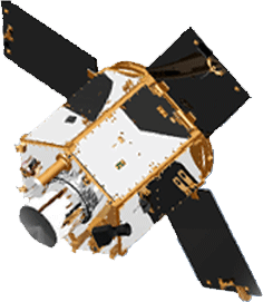
Ofeq-7 is part of the Ofeq family of Earth observation satellites designed and built by Israel Aerospace Industries (IAI) for the Israel Ministry of Defense.
The Earth Remote Observation System-A was part of the EROS family of Israeli commercial Earth observation satellites, designed and manufactured by Israel Aircraft Industries (IAI). This was the first satellite in the series. The satellite was owned and operated by ImageSat International, ImageSat International N.V. (ISI) headquartered at Limassol, Cyprus, and incorporated in the Netherlands Antilles, Cayman Islands.

The Mohammed bin Rashid Space Centre is a Dubai government organisation working on the UAE space programme, which includes various space satellite projects, the Emirates Mars Mission, the Emirates Lunar Mission, and the UAE astronaut programme. The centre actively works to promote space science and research in the region. The centre encompasses the Emirates Institution for Advanced Science and Technology (EIAST).

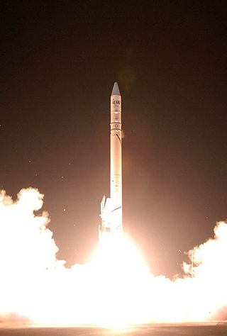
Vegetation and Environment monitoring on a New Micro-Satellite (VENμS) is a near polar Sun-synchronous orbit microsatellite. It is a joint project of the Israeli Space Agency and CNES. The project was signed upon in April 2005 and was launched on the 2nd of August 2017. The microsatellite, which was set to cost the ISA US$20 million and CNES €10 million, was designed and built by IAI and Rafael under ISA's supervision.

KhalifaSat, is a remote sensing Earth observation satellite that was designed and built at the Space Technology Laboratories of the Mohammed bin Rashid Space Centre in Dubai. It is considered the first entirely Emirati-made satellite. It launched into orbit on 30 October 2018 from Japan's Tanegashima Space Center using the Korean Satrec SI-300 bus.

Gaofen is a series of Chinese high-resolution Earth imaging satellites launched as part of the China High-resolution Earth Observation System (CHEOS) program. CHEOS is a state-sponsored, civilian Earth-observation program used for agricultural, disaster, resource, and environmental monitoring. Proposed in 2006 and approved in 2010, the CHEOS program consists of the Gaofen series of space-based satellites, near-space and airborne systems such as airships and UAVs, ground systems that conduct data receipt, processing, calibration, and taskings, and a system of applications that fuse observation data with other sources to produce usable information and knowledge.
Satellogic is a company specializing in Earth-observation satellites, founded in 2010 by Emiliano Kargieman and Gerardo Richarte.
TeLEOS-1 is Singapore's first commercial Earth observation satellite launched on a PSLV-C29 vehicle of the Indian Space Research Organisation from Satish Dhawan Space Centre at Sriharikota on 16 December 2015 along with five other satellites developed in Singapore. The satellite is aimed at providing high temporal imagery and geospatial solutions for homeland security and border control; maritime monitoring and disaster management around the equatorial belt. TeLEOS-1 is developed by ST Engineering.

Capella Space is an American space company with satellite and declassified SAR data solutions for government and commercial use. It offers space-based radar Earth observation satellites equipped with synthetic-aperture radar that can collect imagery through clouds and at night. The company is based in San Francisco, California with offices in Washington, D.C., and Louisville, Colorado. It was founded by Payam Banazadeh, a former engineer at Jet Propulsion Laboratory of NASA, and William Walter Woods.
Biomass is an Earth observing satellite planned for launch by the European Space Agency (ESA) in 2024 on a Vega launch vehicle.

Satrec Initiative Co., Ltd. or SI is a South Korean satellite manufacturing company headquartered in Daejeon, South Korea The company was founded in 1999 by the engineers who developed the first Korean satellite (KITSAT-1) at KAIST SaTRec. The company designs and builds Earth observation satellites called SpaceEye-series, and it provides various space components, including high resolution electro-optical payloads and star-trackers. SI's first satellite was a Malaysian Earth observation satellite, RazakSAT launched in 2009. SI has two subsidiaries: SI Imaging Services (SIIS) is the exclusive image data provider of KOMPSAT-series, and SI Analytics (SIA) provides AI-native GEOINT solutions for satellite imagery. SI also spun-off SI Detection (SID), which provides radiation monitoring solutions.
