
The Geostationary Operational Environmental Satellite (GOES), operated by the United States' National Oceanic and Atmospheric Administration (NOAA)'s National Environmental Satellite, Data, and Information Service division, supports weather forecasting, severe storm tracking, and meteorology research. Spacecraft and ground-based elements of the system work together to provide a continuous stream of environmental data. The National Weather Service (NWS) and the Meteorological Service of Canada use the GOES system for their North American weather monitoring and forecasting operations, and scientific researchers use the data to better understand land, atmosphere, ocean, and climate dynamics.

A weather satellite or meteorological satellite is a type of Earth observation satellite that is primarily used to monitor the weather and climate of the Earth. Satellites can be polar orbiting, or geostationary.

The Defense Meteorological Satellite Program (DMSP) monitors meteorological, oceanographic, and solar-terrestrial physics for the United States Department of Defense. The program is managed by the United States Space Force with on-orbit operations provided by the National Oceanic and Atmospheric Administration (NOAA). The mission of the satellites was revealed in March 1973. They provide cloud cover imagery from polar orbits that are Sun-synchronous at nominal altitude of 830 km (520 mi).

The Japan Aerospace Exploration Agency (JAXA) is the Japanese national air and space agency. Through the merger of three previously independent organizations, JAXA was formed on 1 October 2003. JAXA is responsible for research, technology development and launch of satellites into orbit, and is involved in many more advanced missions such as asteroid exploration and possible human exploration of the Moon. Its motto is One JAXA and its corporate slogan is Explore to Realize.

NOAA-17, also known as NOAA-M before launch, was an operational, polar orbiting, weather satellite series operated by the National Environmental Satellite Service (NESS) of the National Oceanic and Atmospheric Administration (NOAA). NOAA-17 also continued the series of Advanced TIROS-N (ATN) spacecraft begun with the launch of NOAA-8 (NOAA-E) in 1983 but with additional new and improved instrumentation over the NOAA A-L series and a new launch vehicle.

NOAA-16, also known as NOAA-L before launch, was an operational, polar orbiting, weather satellite series operated by the National Environmental Satellite Service (NESS) of the National Oceanic and Atmospheric Administration (NOAA). NOAA-16 continued the series of Advanced TIROS-N (ATN) spacecraft that began with the launch of NOAA-8 (NOAA-E) in 1983; but it had additional new and improved instrumentation over the NOAA A-K series and a new launch vehicle. It was launched on 21 September 2000 and, following an unknown anomaly, it was decommissioned on 9 June 2014. In November of 2015 it broke up in orbit, creating more than 200 pieces of debris.

NOAA-18, also known as NOAA-N before launch, is an operational, polar orbiting, weather satellite series operated by the National Environmental Satellite Service (NESS) of the National Oceanic and Atmospheric Administration (NOAA). NOAA-18 also continued the series of Advanced TIROS-N (ATN) spacecraft begun with the launch of NOAA-8 (NOAA-E) in 1983 but with additional new and improved instrumentation over the NOAA A-M series and a new launch vehicle. NOAA-18 is in an afternoon equator-crossing orbit and replaced NOAA-17 as the prime afternoon spacecraft.

NOAA-15, also known as NOAA-K before launch, is an operational, polar-orbiting of the NASA-provided Television Infrared Observation Satellite (TIROS) series of weather forecasting satellite operated by National Oceanic and Atmospheric Administration (NOAA). NOAA-15 was the latest in the Advanced TIROS-N (ATN) series. It provided support to environmental monitoring by complementing the NOAA/NESS Geostationary Operational Environmental Satellite program (GOES).
The Himawari geostationary satellites, operated by the Japan Meteorological Agency (JMA), support weather forecasting, tropical cyclone tracking, and meteorology research. Most meteorological agencies in East Asia, Southeast Asia, Australia and New Zealand use the satellites for their own weather monitoring and forecasting operations.

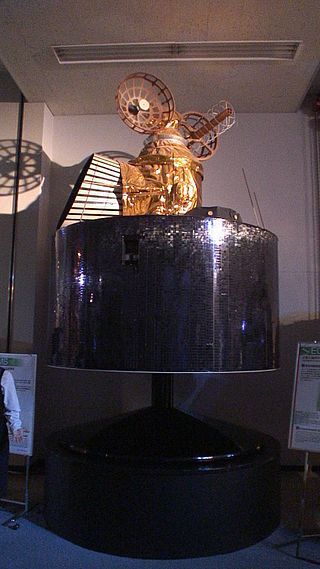
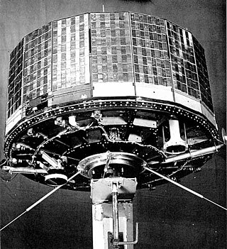
GOES-9, known as GOES-J before becoming operational, was an American weather satellite, which formed part of the U.S. National Oceanic and Atmospheric Administration's Geostationary Operational Environmental Satellite system. It was launched in 1995, and operated until 2007 when it was retired and boosted to a graveyard orbit. At launch, the satellite had a mass of 2,105 kilograms (4,641 lb), and an expected operational lifespan of three years. It was built by Space Systems/Loral, based on the LS-1300 satellite bus, and was the second of five GOES-I series satellites to be launched.

The Suomi National Polar-orbiting Partnership, previously known as the National Polar-orbiting Operational Environmental Satellite System Preparatory Project (NPP) and NPP-Bridge, is a weather satellite operated by the United States National Oceanic and Atmospheric Administration (NOAA). It was launched in 2011 and is currently in operation.
GOES-16, formerly known as GOES-R before reaching geostationary orbit, is the first of the GOES-R series of Geostationary Operational Environmental Satellites (GOES) operated by NASA and the National Oceanic and Atmospheric Administration (NOAA). GOES-16 serves as the operational geostationary weather satellite in the GOES East position at 75.2°W, providing a view centered on the Americas. GOES-16 provides high spatial and temporal resolution imagery of the Earth through 16 spectral bands at visible and infrared wavelengths using its Advanced Baseline Imager (ABI). GOES-16's Geostationary Lightning Mapper (GLM) is the first operational lightning mapper flown in geostationary orbit. The spacecraft also includes four other scientific instruments for monitoring space weather and the Sun.

Himawari 8 (ひまわり8号) is a Japanese weather satellite, the 8th of the Himawari geostationary weather satellites operated by the Japan Meteorological Agency. The spacecraft was constructed by Mitsubishi Electric with assistance from Boeing, and is the first of two similar satellites to be based on the DS2000 satellite bus. Himawari 8 entered operational service on 7 July 2015 and is the successor to MTSAT-2 which was launched in 2006.
Himawari 9 is a Japanese weather satellite, the 9th of the Himawari geostationary weather satellite operated by the Japan Meteorological Agency. The spacecraft was constructed by Mitsubishi Electric, and is the second of two similar satellites to be based on the DS-2000 bus.

TIROS 3 was a spin-stabilized meteorological satellite. It was the third in a series of Television Infrared Observation Satellites.
TIROS 4 was a spin-stabilized meteorological satellite. It was the fourth in a series of Television Infrared Observation Satellites.

TIROS 6 was a spin-stabilized meteorological satellite. It was the sixth in a series of Television Infrared Observation Satellites.

TIROS-8 was a spin-stabilized meteorological satellite. It was the eighth in a series of Television Infrared Observation Satellites.

NOAA-1 was a weather satellite operated by the National Oceanic and Atmospheric Administration (NOAA). It was part of a series of satellites called ITOS, or improved TIROS. ITOS-B was released on October 21, 1971, from the Vandenberg Air Force Base, California, with a Delta rocket. It failed to achieve a successful Earth orbit. A malfunction in the second stage launch vehicle caused the spacecraft to reenter the Earth's atmosphere about 1 hour after lift-off.
NOAA-5, also known as ITOS-H was a weather satellite operated by the National Oceanic and Atmospheric Administration (NOAA). It was part of a series of satellites called ITOS, or improved TIROS, being the last of the series. NOAA-5 was launched on a Delta rocket on July 29, 1976.
