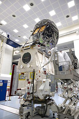
Envisat is a large Earth-observing satellite which has been inactive since 2012. It is still in orbit and considered space debris. Operated by the European Space Agency (ESA), it was the world's largest civilian Earth observation satellite.
The Earth Observing System (EOS) is a program of NASA comprising a series of artificial satellite missions and scientific instruments in Earth orbit designed for long-term global observations of the land surface, biosphere, atmosphere, and oceans. Since the early 1970s, NASA has been developing its Earth Observing System, launching a series of Landsat satellites in the decade. Some of the first included passive microwave imaging in 1972 through the Nimbus 5 satellite. Following the launch of various satellite missions, the conception of the program began in the late 1980s and expanded rapidly through the 1990s. Since the inception of the program, it has continued to develop, including; land, sea, radiation and atmosphere. Collected in a system known as EOSDIS, NASA uses this data in order to study the progression and changes in the biosphere of Earth. The main focus of this data collection surrounds climatic science. The program is the centrepiece of NASA's Earth Science Enterprise.

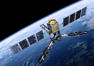
European Remote Sensing satellite (ERS) was the European Space Agency's first Earth-observing satellite programme using a polar orbit. It consisted of two satellites, ERS-1 and ERS-2, with ERS-1 being launched in 1991.

Aeolus, or, in full, Atmospheric Dynamics Mission-Aeolus (ADM-Aeolus), was an Earth observation satellite operated by the European Space Agency (ESA). It was built by Airbus Defence and Space, launched on 22 August 2018, and operated until it was deorbited and re-entered the atmosphere over Antarctica on 28 July 2023. ADM-Aeolus was the first satellite with equipment capable of performing global wind-component-profile observation and provided much-needed information to improve weather forecasting. Aeolus was the first satellite capable of observing what the winds are doing on Earth, from the surface of the planet and into the stratosphere 30 km high.

CALIPSO was a joint NASA (USA) and CNES (France) environmental satellite, built in the Cannes Mandelieu Space Center, which was launched atop a Delta II rocket on April 28, 2006. Its name stands for Cloud-Aerosol Lidar and Infrared Pathfinder Satellite Observations. CALIPSO launched alongside CloudSat.

PARASOL was a French-built Earth observing research satellite. It carried an instrument called POLDER which studied the radiative and microphysical properties of clouds and aerosols.

GCOM, is a JAXA project of long-term observation of Earth environmental changes. As a part of Japan's contributions to GEOSS, GCOM will be continued for 10 to 15 years with observation and utilization of global geophysical data such as precipitation, snow, water vapor, aerosol, for climate change prediction, water management, and food security. On May 18, 2012, the first satellite "GCOM-W" was launched. On December 23, 2017, the second satellite "GCOM-C1" was launched.

Sentinel-1 is the first of the Copernicus Programme satellite constellations conducted by the European Space Agency. The mission was originally composed of a constellation of two satellites, Sentinel-1A and Sentinel-1B, which shared the same orbital plane. Two more satellites, Sentinel-1C and Sentinel-1D are in development. Sentinel-1B was retired following a power supply issue on December 23, 2021, leaving Sentinel-1A the only satellite of the constellation currently operating. Sentinel-1C is currently planned to launch in the final quarter of 2024.

Sentinel-3 is an Earth observation heavy satellite series developed by the European Space Agency as part of the Copernicus Programme. As of 2024, it consists of 2 satellites: Sentinel-3A and Sentinel-3B. After initial commissioning, each satellite was handed over to EUMETSAT for the routine operations phase of the mission. Two recurrent satellites, Sentinel-3C and Sentinel-3D, will follow in approximately 2025 and 2028 respectively to ensure continuity of the Sentinel-3 mission.
Soil Moisture and Ocean Salinity (SMOS) is a satellite which forms part of ESA's Living Planet Programme. It is intended to provide new insights into Earth's water cycle and climate. In addition, it is intended to provide improved weather forecasting and monitoring of snow and ice accumulation.
The Living Planet Programme (LPP) is a programme within the European Space Agency which is managed by the Earth Observation Programmes Directorate. LPP consists of two classes of Earth observation missions including research missions known as Earth Explorers, and the Earth Watch class of missions whose objective is to develop support operational applications such as numerical weather forecasting or resource management.

CryoSat-2 is a European Space Agency (ESA) Earth Explorer Mission that launched on April 8, 2010. CryoSat-2 is dedicated to measuring polar sea ice thickness and monitoring changes in ice sheets. Its primary objective is to measure the thinning of Arctic sea ice, but has applications to other regions and scientific purposes, such as Antarctica and oceanography.
The Advanced Along Track Scanning Radiometer (AATSR) is one of the Announcement of Opportunity (AO) instruments on board the European Space Agency (ESA)'s Envisat satellite.
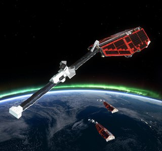
Swarm is a European Space Agency (ESA) mission to study the Earth's magnetic field. High-precision and high-resolution measurements of the strength, direction and variations of the Earth's magnetic field, complemented by precise navigation, accelerometer and electric field measurements, will provide data for modelling the geomagnetic field and its interaction with other physical aspects of the Earth system. The results offer a view of the inside of the Earth from space, enabling the composition and processes of the interior to be studied in detail and increase our knowledge of atmospheric processes and ocean circulation patterns that affect climate and weather.
CryoSat-1, also known as just CryoSat, was a European Space Agency satellite which was lost in a launch failure in 2005. The satellite was launched as part of the European Space Agency's CryoSat mission, which aims to monitor ice in the high latitudes. The second mission satellite, CryoSat-2, was successfully launched in April 2010.
ADEOS II was an Earth observation satellite (EOS) launched by NASDA, with contributions from NASA and CNES, in December 2002. and it was the successor to the 1996 mission ADEOS I. The mission ended in October 2003 after the satellite's solar panels failed.
ICESat-2, part of NASA's Earth Observing System, is a satellite mission for measuring ice sheet elevation and sea ice thickness, as well as land topography, vegetation characteristics, and clouds. ICESat-2, a follow-on to the ICESat mission, was launched on 15 September 2018 onboard Delta II as the final flight from Vandenberg Air Force Base in California, into a near-circular, near-polar orbit with an altitude of approximately 496 km (308 mi). It was designed to operate for three years and carry enough propellant for seven years. The satellite orbits Earth at a speed of 6.9 kilometers per second (4.3 mi/s).
Biomass is an Earth observing satellite planned for launch by the European Space Agency (ESA) in 2024 on a Vega launch vehicle.

Explorer 60, also called as SAGE and was the second of the Applications Explorer Missions (AEM), AEM-B, was a NASA scientific satellite launched on 18 February 1979, from Wallops Flight Facility (WFF) by a Scout D-1 launch vehicle.

FORUM is an Earth observing satellite that is scheduled to launch in 2027.