
Cimarron is a village in Colfax County, New Mexico, United States, which sits on the eastern slopes of the Sangre de Cristo Mountains. The population was 1,021 at the 2010 census, making it the fourth most populous municipality in Colfax County.

The San Juan River is a major tributary of the Colorado River in the Southwestern United States, providing the chief drainage for the Four Corners region of Colorado, New Mexico, Utah, and Arizona. Originating as snowmelt in the San Juan Mountains of Colorado, it flows 383 miles (616 km) through the deserts of northern New Mexico and southeastern Utah to join the Colorado River at Glen Canyon.

The Gunnison River is located in western Colorado, and it is one of the largest tributaries of the Colorado river. The 180-mile (289-km) long river flows east to west, and it has a drainage area of 7,923 square miles (20,520 km2) according to the USGS. The drainage basin of the Gunnison River collects water from different habitats, such as forests and alpine meadows, located the along Continental Divide. As the river flows westward, it carves through the San Juan Mountains. It flows into the Colorado River at Grand Junction.

The New River is a river which flows through the U.S. states of North Carolina, Virginia, and West Virginia before joining with the Gauley River to form the Kanawha River at the town of Gauley Bridge, West Virginia. Part of the Ohio River watershed, it is about 360 miles (580 km) long.

Keystone Lake is a reservoir in northeastern Oklahoma on the Arkansas and Cimarron rivers. It is located upstream about 23 miles (37 km) from Tulsa. It was created in 1968 when the Keystone Dam was completed. The primary purposes are: flood control, hydroelectric power generation, wildlife management and recreation.

Missisquoi National Wildlife Refuge is a National Wildlife Refuge located in the eastern shore of Lake Champlain in the U.S. state of Vermont. The refuge is in Franklin County in the northwest corner of the state near the International Boundary with Canada. It is the only National Wildlife Refuge located entirely in Vermont, and is administered by the United States Fish and Wildlife Service.

Lake Havasu is a large reservoir formed by Parker Dam on the Colorado River, on the border between San Bernardino County, California and La Paz County, Arizona. Lake Havasu City sits on the Arizona (eastern) side of the lake with its Californian counterpart of Havasu Lake directly across the lake. The reservoir has an available capacity of 619,400 acre-feet (764,000,000 m3). The concrete arch dam was built by the United States Bureau of Reclamation between 1934 and 1938. The lake's primary purpose is to store water for pumping into two aqueducts. Prior to the dam construction, the area was home to the Mojave people. The lake was named after the Mojave word for blue. In the early 19th century, it was frequented by beaver trappers. Spaniards also began to mine the areas along the river.

The Arapaho National Wildlife Refuge is a United States National Wildlife Refuge located in north-central Colorado. It is one of over 560 national wildlife refuges which manages and protects natural resources for future generations. The refuge is located in North Park in central Jackson County south of the town of Walden. The refuge was established in 1967 to furnish waterfowl with a suitable place to nest and rear their young. It was created in part to offset losses of nesting habitat in the prairie wetland region of the Midwest. It is located in the valley of the Illinois River, a tributary of the North Platte River. It is administered by the United States Fish and Wildlife Service.

Umbagog Lake is a wilderness lake located in Coös County, New Hampshire, and Oxford County, Maine. It is one of the most pristine lakes in the state of New Hampshire. It lies in the towns of Errol, New Hampshire, and Upton, Maine, as well as the townships of Cambridge, New Hampshire, and Magalloway Plantation, Maine. The name Umbagog is properly pronounced with the stress on the second syllable (um-BAY-gog) and is said to come from the Abenaki word for "shallow water". Both "Lake Umbagog" and "Umbagog Lake" are commonly used and accepted when referring to the body of water.
The Choctaw National Wildlife Refuge is a 4,218 acre (17.07 km²) National Wildlife Refuge located along the Tombigbee River near Coffeeville, Alabama. Named after the Choctaw tribe, it was established to provide a wood duck brood habitat and serve as a protected wintering area for waterfowl.

Goose Pond is a 625-acre (2.5 km2) water body located in Grafton County in western New Hampshire, United States, in the towns of Canaan and Hanover. It is considered a great pond by the state of New Hampshire. The lake has 6.3 miles (10.1 km) of shoreline, and is approximately 3 miles (5 km) long by 0.5 miles (0.8 km) wide. All but the northernmost end of the pond is in the town of Canaan. The average depth of the pond is approximately 10 feet (3.0 m), with the deepest part approximately 35 feet (11 m). The lake is part of the Mascoma River watershed, flowing to the Connecticut River.

The Cimarron River, flowing entirely in New Mexico, was also known as La Flecha or Semarone. Its headwaters are Moreno, Sixmile, and Cieneguilla creeks in the Sangre de Cristo Mountains, which feed into Eagle Nest Dam. From the dam, it runs for 60 miles (97 km) to below the city of Springer, New Mexico in the Taylor Springs area, where it flows into the Canadian River, the southwesternmost major tributary flowing into the Mississippi River via the Arkansas River sub-basin.

Navajo Dam is a dam on the San Juan River, a tributary of the Colorado River, in northwestern New Mexico in the United States. The 402-foot (123 m) high earthen dam is situated in the foothills of the San Juan Mountains about 44 miles (71 km) upstream and east of Farmington, New Mexico. It was built by the U.S. Bureau of Reclamation (Reclamation) in the 1960s to provide flood control, irrigation, domestic and industrial water supply, and storage for droughts. A small hydroelectric power plant was added in the 1980s.
The Maxwell Land Grant, also known as the Beaubien-Miranda Land Grant, was a 1,714,765-acre (6,939.41 km2) Mexican land grant in Colfax County, New Mexico, and part of adjoining Las Animas County, Colorado. This 1841 land grant was one of the largest contiguous private landholdings in the history of the United States. The New Mexico towns of Cimarron, Colfax, Dawson, Elizabethtown, French, Lynn, Maxwell, Miami, Raton, Rayado, Springer, Ute Park and Vermejo Park came to be located within the grant, as well as numerous other towns that are now ghost towns.

The Prineville Reservoir is in the high desert hills of Central Oregon, Oregon, United States. The reservoir is on the Crooked River 14 miles (22.5 km) southeast of Prineville, and 29 miles (46.7 km) east of Bend. This reservoir is a popular retreat for most of Central Oregon. It is near the geographic center of Oregon. Prineville Reservoir State Park is managed by the Oregon Parks and Recreation Department.

Hardy Lake, originally named Quick Creek Reservoir, is an Indiana state reservoir in Scott and Jefferson counties, Indiana. It is located four miles (6 km) east of Austin, Indiana and 35 miles (56 km) north of Louisville, Kentucky. It is the smallest reservoir maintained by the state of Indiana, measuring 2,448 acres (9.9 km2) of total property, and 741 acres (3.0 km2) of surface area for the lake. The lake is approximately 38 feet (12 m) deep.
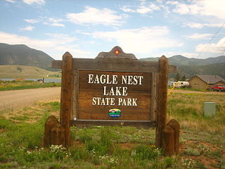
Eagle Nest Lake State Park is a state park in New Mexico, United States.

Cimarron Canyon State Park is a state park of New Mexico, United States, located 3 miles (4.8 km) east of Eagle Nest in the Colin Neblett Wildlife Area. The park extends for 8 miles (13 km) along the Cimarron Canyon between Tolby Creek and Ute Park. The Palisades Sill forms spectacular cliffs above the Cimarron River here.
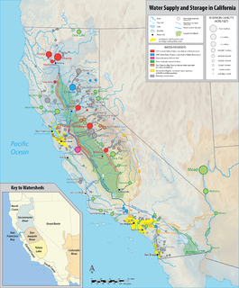
California's interconnected water system serves over 30 million people and irrigates over 5,680,000 acres (2,300,000 ha) of farmland. As the world's largest, most productive, and potentially most controversial water system, it manages over 40 million acre-feet (49 km3) of water per year.

Waconda Lake, also known as Glen Elder Reservoir, is a reservoir in Mitchell County and Osborne County, Kansas, United States. Built and managed by the U.S. Bureau of Reclamation for flood control and irrigation, it is also used for recreation. Glen Elder State Park is located on its north shore.

