East Cannington, Western Australia

Last updated

East Cannington
Perth,  Western Australia
East Cannington, Western Australia
Coordinates 32°00′29″S115°57′29″E / 32.008°S 115.958°E / -32.008; 115.958
Population6,512 (SAL 2021) [1]
Established1959
Postcode(s) 6107
Area2.9 km2 (1.1 sq mi)
Location11 km (7 mi) from Perth
LGA(s) City of Canning
State electorate(s) Cannington
Federal division(s) Swan
Suburbs around East Cannington:
Queens Park Welshpool Wattle Grove
Cannington East Cannington Kenwick
Cannington Beckenham Beckenham

East Cannington is a southeastern suburb of Perth, Western Australia. Its local government area is the City of Canning.

Contents

History

East Cannington, previously part of Queens Park Road Board District and once incorporating present day Beckenham, was largely a semi-rural area, with only the area near the railway used for housing. In 1959, the suburb was gazetted as a postal district. Many farms and horse agistment properties once populated East Cannington until developers realised its potential in the 1990s and thus almost all available land has now given way to suburban housing.

In Fred Carden's book Along the Canning East Cannington had a few notable industries, including a jam factory near the site of the old Cannington Train Station and a garment manufacturer in Lacey Street. [2]

Evidence of the early retail trade can still be gleaned from the weatherboard shops now making up the East Cannington General Store opposite the old Cannington Railway Station site.

Geography

East Cannington is bounded by the Armadale railway line to the southwest, Thomas and Gibbs Streets to the northwest, Welshpool Road to the north and Lacey Street to the southeast. It is at the eastern fringe of urban settlement in the City of Canning, with only semi-rural parts of Kenwick and Wattle Grove between the suburb and the Lesmurdie section of the Darling Scarp. [3]

Facilities

East Cannington is a residential suburb, with a small neighbourhood shopping centre in Gerard Street (now closed and houses are being built[ when? ] where it was) and relying on the nearby Westfield Carousel shopping centre in Cannington boundary for other commercial services. The suburb contains a primary school (Gibbs Street), and Saint Francis Catholic Primary School in Renou Street. Sevenoaks Senior College is nearby. The eastern end of the Welshpool industrial area borders the suburb to the north. A large park along the Welshpool Road border includes a nature reserve of indigenous species and a scout hall. A few other small parks throughout the suburb provide recreational facilities.

Transport

East Cannington is served by the Cannington train station at its western corner, linking the area to the Perth central business district. The suburb is also served by buses from Cannington, including a circular route. All services are operated by the Public Transport Authority.

Bus

Rail

Related Research Articles

<span class="mw-page-title-main">Ferndale, Western Australia</span> Suburb of Perth, Western Australia

Ferndale is a southeastern suburb of Perth, Western Australia. Its local government area is the City of Canning. It is approximately 15 kilometres (9 mi) from Perth's central business district.

<span class="mw-page-title-main">Armadale line</span> Suburban rail line in Perth, Western Australia

The Armadale line is a suburban railway service in Perth, Western Australia, operated by the Public Transport Authority as part of the Transperth system. The Armadale line is 30.4 kilometres (18.9 mi) long, and starts at Perth station, heading south-east of there to serve Perth's south-eastern suburbs, terminating at Armadale station.

<span class="mw-page-title-main">Elizabeth Quay bus station</span> Bus station in Perth, Western Australia

Elizabeth Quay bus station, formerly the Esplanade Busport, is a Transperth bus station, located at the southern edge of the Perth CBD in Western Australia, next to the Perth Convention Exhibition Centre and Elizabeth Quay railway station. It has 35 stands and is served by 55 Transperth routes operated by Path Transit, Swan Transit and Transdev WA. It is also served by South West Coach Lines services.

<span class="mw-page-title-main">Welshpool railway station, Perth</span> Railway station in Perth, Western Australia

Welshpool was a railway station on the Transperth network. It was located on the Armadale and Thornlie lines, 9.5 kilometres from Perth Station serving the suburbs of Welshpool and Bentley, Western Australia.

<span class="mw-page-title-main">Armadale railway station, Perth</span> Railway station in Perth, Western Australia

Armadale railway station is located on the South Western Railway, 30 kilometres from Perth station serving the suburb of Armadale, Brookdale and Haynes. It is the terminating point for Transperth Armadale line services and a calling point for Transwa Australind services.

<span class="mw-page-title-main">Kelmscott railway station</span> Railway station in Perth, Western Australia

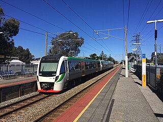
Kelmscott railway station is located on the South Western Railway, 25.9 kilometres from Perth Station in the suburb of Kelmscott. It is served by Armadale Line services which are part of the Transperth network.

<span class="mw-page-title-main">Gosnells railway station</span> Railway station in Perth, Western Australia

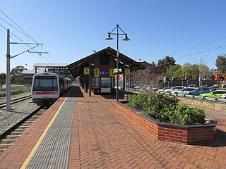
Gosnells railway station is located on the South Western Railway 21 kilometres from Perth Station in the suburb of Gosnells. It is served by Armadale Line services which are part of the Transperth network.

<span class="mw-page-title-main">Maddington railway station</span> Railway station in Perth, Western Australia

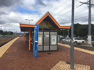
Maddington railway station is on the Transperth network. It is located on the Armadale Line, 17.7 kilometres from Perth Station serving the suburb of Maddington.

<span class="mw-page-title-main">Cannington railway station</span> Railway station in Perth, Western Australia

Cannington is a temporarily closed railway station on the Armadale and Thornlie lines, serving the suburb of Cannington south of Perth, Western Australia. It is located 12.2 kilometres (7.6 mi) from Perth Station, and is part of the Transperth commuter rail network. It temporarily closed on 20 November 2023 as part of the Victoria Park-Canning Level Crossing Removal Project.

<span class="mw-page-title-main">Oats Street railway station</span> Railway station in Perth, Western Australia

Oats Street railway station is a temporarily-closed Transperth suburban railway station in Western Australia, located in the Perth suburbs of Carlisle and East Victoria Park. The station was served by the Armadale and Thornlie lines prior to its closure in November 2023.

<span class="mw-page-title-main">Thornlie railway station</span> Railway station in Perth, Western Australia

Thornlie railway station is a temporarily closed railway station on the Transperth network. It was the terminus of the Thornlie line, a spur of the Armadale Line, seventeen kilometres (11 mi) from Perth Station serving the suburb of Thornlie, Western Australia. Under construction is the Thornlie-Cockburn Link which will link to Cockburn Central railway station along the Mandurah line via two new stations, Nicholson Road railway station and Ranford Road railway station.

<span class="mw-page-title-main">Warwick railway station, Perth</span> Railway station in Perth, Western Australia

Warwick railway station is a railway station on the Transperth network. It is located on the Joondalup line, 13 kilometres (8.1 mi) from Perth station serving the suburb of Warwick.

<span class="mw-page-title-main">Alexander Heights, Western Australia</span> Suburb of Perth, Western Australia

Alexander Heights is a suburb of Perth, Western Australia within the City of Wanneroo.

<span class="mw-page-title-main">Welshpool, Western Australia</span> Suburb of Perth, Western Australia

Welshpool is an inner southeastern suburb of Perth, Western Australia, located mostly within the City of Canning and partially within the Town of Victoria Park.

<span class="mw-page-title-main">Applecross, Western Australia</span> Suburb of Perth, Western Australia

Applecross is an affluent riverside suburb of Perth, Western Australia, bounded by Canning Highway and the Swan River. It is located within the City of Melville.

<span class="mw-page-title-main">Cannington, Western Australia</span> Suburb of Perth, Western Australia

Cannington is a southern suburb of Perth, Western Australia. Its local government area is the City of Canning.

<span class="mw-page-title-main">Queens Park, Western Australia</span> Suburb of Perth, Western Australia

Queens Park is a suburb of Perth, Western Australia, located within the City of Canning. Its postcode is 6107.

<span class="mw-page-title-main">Wattle Grove, Western Australia</span> Suburb of Perth, Western Australia

Wattle Grove is a suburb of Perth, Western Australia, located within the City of Kalamunda.

<span class="mw-page-title-main">Rockingham railway station, Perth</span> Railway station in Perth, Western Australia

Rockingham railway station is a railway station in Rockingham, a suburb of Perth, Western Australia. It is on the Mandurah railway line, which is part of the Transperth commuter rail network. It has two side platforms, linked by a pedestrian overpass accessed by stairs, a lift, and escalators. Services run every 10 minutes during peak, and every 15 minutes between peak. The journey to Perth railway station is 43.2 kilometres (26.8 mi), and takes 34 minutes. The journey to Mandurah railway station is 27.6 kilometres (17.1 mi), and takes 17 minutes. The station has a bus interchange with twelve bus stands, and 14 regular bus routes.

References

  1. Australian Bureau of Statistics (28 June 2022). "East Cannington (suburb and locality)". Australian Census 2021 QuickStats. Retrieved 28 June 2022.  OOjs UI icon edit-ltr-progressive.svg
  2. Carden, F.G. Along the Canning: A History of the City of Canning Western Australia, Covering its progress from Roads Board to Shire, to Town, to City City of Canning, 1st Edition 1968, 2nd edition, 1991.
  3. Department of Land Information. StreetSmart Perth Street Directory (54th ed.). West Australian Newspapers Ltd. pp. Map 405. ISBN   978-0-909439-67-5.
  4. "Route 202". Bus Timetable 14 (PDF). Transperth. 28 August 2023 [effective from 20 November 2023].
  5. "Route 203". Bus Timetable 14 (PDF). Transperth. 28 August 2023 [effective from 20 November 2023].
  6. "Route 229". Bus Timetable 5 (PDF). Transperth. 11 January 2024 [effective from 28 January 2024].
  7. "Route 280". Bus Timetable 110 (PDF). Transperth. 12 January 2024 [effective from 4 February 2024].
  8. "Route 282". Bus Timetable 94 (PDF). Transperth. 10 October 2023 [effective from 20 November 2023].
  9. "Route 283". Bus Timetable 94 (PDF). Transperth. 10 October 2023 [effective from 20 November 2023].