Lynwood, Western Australia

Last updated

Lynwood
Perth,  Western Australia
Lynwood, Western Australia
Coordinates 32°02′24″S115°55′44″E / 32.040138°S 115.928837°E / -32.040138; 115.928837 (Lynwood)
Population3,541 (SAL 2021) [1]
Established1965
Postcode(s) 6147
Area1.8 km2 (0.7 sq mi)
Location13.3 km (8 mi) from the Perth CBD
LGA(s) City of Canning
State electorate(s) Cannington
Federal division(s) Tangney
Suburbs around Lynwood:
Ferndale Cannington
Parkwood Lynwood Langford
Riverton

Lynwood is a small southeastern suburb of Perth, the capital city of Western Australia. Its local government area is the City of Canning.

Contents

History

Lynwood was first settled by Henry Willett of Willett & Co, who was granted Canning Location 21 on the Canning River (which included nearby Parkwood) and settled in the area in June 1832. In November 1964, the Shire of Canning proposed the names "Burtsdale" and "Willetton" for Willetton and Lynwood/Parkwood respectively, the name Burtsdale honouring Septimus Burt, who purchased the land in 1882. In August 1965, developers at Lynwood requested the name "Clovercrest Estate", but finally agreed to "Lynwood". The name Willetton was shifted westwards and Lynwood was gazetted in December 1965. [2] Parkwood was part of Lynwood until 1993.

In the 1960s and 1970s, Lynwood and neighbouring Parkwood were largely settled by new migrants from the United Kingdom who arrived in Perth seeking economic prosperity. Large parcels of land were developed by the British firm Realty Development Corporation (RDC) and heavily marketed to the new English migrants upon their arrival as "home & land packages".

Geography

Lynwood is approximately 13.3 kilometres (8.3 mi) from the central business district of Perth, and is bound by High Road to the south and south-west, Nicholson Road to the east and Metcalfe Road to the north and north-west. The Canning River is about 300 m (1,000 ft) north-east of the suburb's boundary. [3]

The Bannister Creek Park runs through the southern part of Lynwood.

Facilities

Lynwood is a residential suburb with a series of parks connecting along Bannister Creek and parallel to Nicholson Road. It contains a neighbourhood shopping centre with supermarket, post office, estate agency, and a number of food outlets, as well as a community hall and a primary school completed in 2010, which also services the adjoining suburb of Ferndale. Lynwood Senior High School, built in 1975, is in nearby Parkwood.

The Riverton Forum and Westfield Carousel shopping centres are less than 2 km (1 mi) away, as is the Riverton Leisureplex, a large facility with sporting, fitness and recreation facilities that opened on 9 November 2001, [4] operated by the City of Canning and including the council's largest library. Parkwood Shopping Centre was built in 1979, but has recently[ when? ] been demolished due to low patronage and now only consists of a few convenience stores and a small medical clinic. The Lynwood Arms Hotel, a local pub on Metcalfe Road, built in the early 1970s, was demolished in 2014 to make way for an upmarket medium-density housing development.

As at the late 2010s, it was one of the few suburbs, as with Heathridge, Beldon and Craigie up north, where you could see uninterrupted stretches of 1970s housing with the long narrow windows, dark brown colourings, and numerous arches. In other areas, redevelopment has taken place at rapid rates, and streetscapes have become unrecognizable.

Transport

Lynwood is served by Transperth bus services from Cannington, which link it to the central business district. All services are operated by Swan Transit.

Politics

Lynwood has a changing mixed-ethnic population. It generally supports the Australian Labor Party at both federal and state elections.

Related Research Articles

<span class="mw-page-title-main">City of Canning</span> Local government area in Western Australia

The City of Canning is a local government area in the southeastern suburbs of the Western Australian capital city of Perth, about 10 kilometres (6 mi) southeast of Perth's central business district. The City covers an area of 64.8 square kilometres (25.0 sq mi) and had a population of approximately 90,000 as at the 2016 Census.

<span class="mw-page-title-main">Yangebup, Western Australia</span> Suburb of Perth, Western Australia

Yangebup is a southern suburb of Perth, Western Australia in the City of Cockburn. It takes its name from the nearby Yangebup Lake.

<span class="mw-page-title-main">Ferndale, Western Australia</span> Suburb of Perth, Western Australia

Ferndale is a southeastern suburb of Perth, Western Australia. Its local government area is the City of Canning. It is approximately 15 kilometres (9 mi) from Perth's central business district.

<span class="mw-page-title-main">Leeming, Western Australia</span> Suburb of Perth, Western Australia

Leeming is a southern suburb of Perth, Western Australia. It is divided between the three local government areas of the City of Melville, the City of Cockburn (south) and the City of Canning (north-east). It is located approximately 17 kilometres (11 mi) south of the Perth central business district and 13 kilometres (8.1 mi) east of Fremantle.

<span class="mw-page-title-main">Riverton, Western Australia</span> Suburb of Perth, Western Australia

Riverton is a southeastern suburb of Perth, the capital city of Western Australia. Its local government area is the City of Canning.

<span class="mw-page-title-main">Parkwood, Western Australia</span> Suburb of Perth, Western Australia

Parkwood is a southeastern suburb of Perth, the capital city of Western Australia. Its local government area is the City of Canning.

<span class="mw-page-title-main">Duncraig, Western Australia</span> Suburb of Perth, Western Australia

Duncraig is a northern suburb of Perth, the capital city of Western Australia, and is located 16 kilometres (10 mi) north of Perth's central business district (CBD) between Marmion Avenue and Mitchell Freeway. Its local government area is the City of Joondalup.

<span class="mw-page-title-main">Canning Vale, Western Australia</span> Suburb of Perth, Western Australia

Canning Vale is a southern suburb of Perth, 22 km (13.7 mi) from the central business district. Its local government areas are the City of Canning and the City of Gosnells.

<span class="mw-page-title-main">Cannington, Western Australia</span> Suburb of Perth, Western Australia

Cannington is a southern suburb of Perth, Western Australia. Its local government area is the City of Canning.

Rossmoyne is a suburb of Perth, Western Australia, within the City of Canning. Rossmoyne is located 14 kilometres (8.7 mi) south of central Perth, and is bounded by Leach Highway to the south, the Bull Creek to the west, the Canning River to the north, and Shelley to the east.

Shelley is a suburb of Perth, Western Australia, located within the City of Canning.

<span class="mw-page-title-main">Willetton, Western Australia</span> Suburb of Perth, Western Australia

Willetton is a large southern suburb of Perth, Western Australia. Its local government area is the City of Canning.

<span class="mw-page-title-main">Canning River</span> River in Perth, Western Australia

<span class="mw-page-title-main">Rossmoyne Senior High School</span> School in Perth, Western Australia

Rossmoyne Senior High School is a public co-educational high day school in the City of Melville, located on Keith Road, Bull Creek, a southern riverside suburb of Perth, Western Australia.

<span class="mw-page-title-main">High Road, Perth</span>

High Road is a major road running through Lynwood, Parkwood, Ferndale, Riverton, and Willetton in the south-east of Perth, Western Australia. It connects the major roads Leach Highway, and Albany Highway via Nicholson Road, originally built to provide the Gosnells area with direct access to the port city of Fremantle.

<span class="mw-page-title-main">Electoral district of Riverton</span> State electoral district in Perth, Western Australia

Riverton is a Legislative Assembly electorate in the state of Western Australia. Riverton is named for the southern Perth suburb of Riverton, which falls within its borders.

<span class="mw-page-title-main">Victoria Park, Western Australia</span> Suburb of Perth, Western Australia

Victoria Park is an inner south eastern suburb of Perth, Western Australia. Its local government area is the Town of Victoria Park.

<span class="mw-page-title-main">Riverton Bridge</span> Bridge in Perth, Western Australia

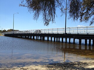
Riverton Bridge is a two-lane road traffic bridge spanning the Canning River at Riverton, in Perth, Western Australia.

<span class="mw-page-title-main">Canning River Regional Park</span> Regional park in Perth, Western Australia

The Canning River Regional Park is the largest of eight regional parks within the Perth metropolitan area. The park covers approximately 6 km (3.7 mi) on both sides of the Canning River between the bridges carrying Nicholson Road and Leach Highway over the Canning River. Canning River is a major tributary of the Swan River in south western Western Australia.

<span class="mw-page-title-main">Lynwood Senior High School</span> School in Australia

Lynwood Senior High School is an independent public co-educational specialist high day school in the City of Canning, located in the Perth suburb of Parkwood, Western Australia.

References

  1. Australian Bureau of Statistics (28 June 2022). "Lynwood (WA) (Suburb and Locality)". Australian Census 2021 QuickStats. Retrieved 28 June 2022.  OOjs UI icon edit-ltr-progressive.svg
  2. "History of metropolitan suburb names – L". Western Australian Land Information Authority. Archived from the original on 16 March 2022. Retrieved 17 January 2007.
  3. 2007 StreetSmart directory, Department of Lands and Surveys, Perth.
  4. "Riverton Leisureplex - City Of Canning". Archived from the original on 1 March 2008. Retrieved 7 November 2006.

Commons-logo.svg Media related to Lynwood, Western Australia at Wikimedia Commons