
The City of Canning is a local government area in the southeastern suburbs of the Western Australian capital city of Perth, about 10 kilometres (6 mi) southeast of Perth's central business district. The City covers an area of 64.8 square kilometres (25.0 sq mi) and had a population of approximately 90,000 as at the 2016 Census.
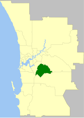
The City of Gosnells is a local government area in the southeastern suburbs of the Western Australian capital city of Perth, located northwest of Armadale and about 20 kilometres (12 mi) southeast of Perth's central business district. The City covers an area of 128 square kilometres (49.42 sq mi), a portion of which is state forest rising into the Darling Scarp to the east, and had a population of approximately 118,000 at the 2016 Census. The largest activity centre in the City is the Central Maddington shopping centre. District centres exist in the Gosnells town centre, Thornlie and Canning Vale.

Subiaco is an inner-western suburb of Perth, the capital of Western Australia. It is approximately 3 km (1.9 mi) west of Perth's central business district, in the City of Subiaco local government area. Historically a working-class suburb containing a mixture of industrial and commercial land uses, since the 1990s the area has been one of Australia's most celebrated urban redevelopment projects. It remains a predominantly low-rise, urban village neighbourhood centred around Subiaco train station and Rokeby Road.

Coolbellup is a suburb in Perth, Western Australia, located 15 kilometres (9.3 mi) south of the central business district within the local government area of the City of Cockburn.

Seaforth railway station is a suburban railway station in Gosnells, a suburb of Perth, Western Australia. It is on the Armadale line which is part of the Transperth network, and is 22.6 kilometres (14.0 mi) southwest of Perth station and 7.8 kilometres (4.8 mi) north of Armadale station. The station opened on 4 May 1948 with low level platforms. High level platforms were added in 1968. The station consists of two side platforms with a pedestrian level crossing. It is not fully accessible due to steep ramps and a lack of tactile paving.
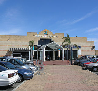
Thornlie is a large residential suburb of Perth, the capital city of Western Australia, located 15 kilometres (9.3 mi) south-east of the city's central business district. It is a part of the City of Gosnells local government area. The Canning River runs through the northern side of the suburb. Since the 1950s the suburb has developed in approximately five stages; north-east Thornlie (1950s–60s), south Thornlie (1970s–80s), Crestwood (1970s), Castle Glen (1980s) and Forest Lakes.

Bullsbrook is a northern suburb of Perth, Western Australia in the outer metropolitan area. It is located in the City of Swan. The original Bullsbrook townsite is located slightly west of the current town, on the 17 km mark of the Midland Railway. Bullsbrook is also home to the RAAF Pearce airbase, a major training facility for the Royal Australian Air Force. The suburb is situated on the Great Northern Highway, 25 kilometres north of the Midland Strategic Regional Centre. It is well serviced by several major transport networks including the Great Northern Highway, Railway Parade and the Brand Highway to the north, Chittering Road to the east and Neaves Road to the west. Bullsbrook is also adjacent to the State rail network, providing an opportunity for the development of an intermodal freight transport hub. The site is further strengthened by linkage to the planned Perth-Darwin National Highway via Stock Road.

Kelmscott is a southeastern suburb of Perth, Western Australian within the local government area of the City of Armadale. It is 23 kilometres (14 mi) southeast of Perth along the Albany Highway.
Bateman is a suburb of Perth, Western Australia, located within the City of Melville.

Willagee is a suburb of Perth, Western Australia 15 kilometres (9 mi) south-southwest of the Perth central business district. It is within the local government area of City of Melville, and the electoral district of Willagee, which takes its name from the suburb.

Canning Vale is a southern suburb of Perth, 22 km (13.7 mi) from the central business district. Its local government areas are the City of Canning and the City of Gosnells.

Willetton is a large southern suburb of Perth, Western Australia. Its local government area is the City of Canning.
North Lake is a suburb located 18 kilometres (11 mi) south of the central business district of Perth, the capital of Western Australia, and 8 kilometres (5 mi) from the Indian Ocean. Named after the eponymous lake, the suburb and lake are located within the City of Cockburn local government area.

Kenwick, Western Australia is a mixed residential, light industrial and semi-rural suburb located in the south-east of Perth, Western Australia, located within the City of Gosnells. A large portion of the suburb is composed of remnant agricultural land organized as smallholdings of several acres, as well as relatively pristine native wetlands, including the Brixton Street Wetlands which are of significant conservation value. It also contains several sites of historical significance relating to its status as one of the early farming communities of the Swan River Colony.
Maddington is a suburb 20 kilometres (12 mi) southeast of the central business district of Perth, the capital of Western Australia, within the City of Gosnells local government area. Maddington is a mixed-use suburb containing major residential, retail and industrial sections as well as some semi-rural areas.

Tonkin Highway is an 81-kilometre-long (50 mi) north–south highway and partial freeway in Perth, Western Australia, linking Perth Airport and Kewdale with the city's north-eastern and south-eastern suburbs. As of April 2020, the northern terminus is at the interchange with Brand Highway and Great Northern Highway in Muchea, and the southern terminus is at Thomas Road in Oakford. It forms the entire length of State Route 4, and connects to several major roads. Besides Brand Highway and Great Northern Highway, it also connects to Reid Highway, Great Eastern Highway, Leach Highway, Roe Highway, and Albany Highway.

Gosnells is a suburb located within the City of Gosnells. Gosnells is approximately 20 kilometres (12 mi) south-east of the Perth central business district. It contains the Gosnells town centre which includes the Council offices, library and the Gosnells Railway Station.

Nedlands is an affluent western suburb of Perth, the capital city of Western Australia. It is a part of the local government areas of the City of Nedlands and the City of Perth. It is about 7 kilometres (4 mi) from the Perth CBD via either Thomas Street or Mounts Bay Road.

Bayswater is a suburb 6 km (4 mi) north-east of the central business district (CBD) of Perth, the capital of Western Australia. It is just north of the Swan River, within the City of Bayswater local government area. It is predominantly a low-density residential suburb consisting of single-family detached homes. However, there are several clusters of commercial buildings, most notably in the suburb's town centre, around the intersection of Whatley Crescent and King William Street and a light industrial area in the suburb's east.

Oakford is an outer suburb of Perth, Western Australia, within the Shire of Serpentine-Jarrahdale. The suburb was named in 1982, taking its name from a townsite briefly declared in the area in 1926.
