East Stroudsburg, Pennsylvania

Last updated
East Stroudsburg, Pennsylvania
Borough
East Stroudsburg, Pennsylvania.jpg
East Stroudsburg's borough hall
Seal of East Stroudsburg.png
Monroe County Pennsylvania Incorporated and Unincorporated areas East Stroudsburg Highlighted.svg
Location of East Stroudsburg in Monroe County, Pennsylvania
USA Pennsylvania location map.svg
Red pog.svg
East Stroudsburg
Location of East Stroudsburg in Pennsylvania
Usa edcp location map.svg
Red pog.svg
East Stroudsburg
East Stroudsburg (the United States)
Coordinates: 41°00′05″N75°10′48″W / 41.00139°N 75.18000°W / 41.00139; -75.18000
Country United States
State Pennsylvania
County Monroe
Founded1738
Area
[1]
  Borough2.86 sq mi (7.41 km2)
  Land2.84 sq mi (7.37 km2)
  Water0.02 sq mi (0.04 km2)
Elevation
466 ft (142 m)
Population
 (2020) [2]
  Borough9,669
  Density3,399.79/sq mi (1,312.58/km2)
   Metro
176,567 μSA
Time zone UTC-5 (EST)
  Summer (DST) UTC-4 (EDT)
ZIP Codes
18301-18302
Area code 570
FIPS code 42-21872
Website eaststroudsburgboro.org

East Stroudsburg is a borough in Monroe County, Pennsylvania, and part of the Pocono Mountains region of the state. Originally known as Dansbury, East Stroudsburg was renamed for geographic reasons when the Delaware, Lackawanna, and Western Railroad opened a station in East Stroudsburg. Despite its name being derivative of its bordering borough, Stroudsburg, it has almost twice the population.

Contents

East Stroudsburg is the largest municipality in Monroe County and in the East Stroudsburg, PA Metropolitan Statistical Area [3]

As of the 2020 census, the population of East Stroudsburg was 9,847. [4]

East Stroudsburg is located 42 miles (68 km) northeast of Allentown, 102 miles (164 km) north of Philadelphia, and 75 miles (121 km) west of New York City.

History

In 1737, present-day East Stroudsburg was settled by Daniel Brodhead, a judge from Marbletown, New York, who acquired a 1,000-acre lot of land on and around where Lehigh Valley Hospital–Pocono Hospital currently stands at 206 E. Brown Street in what then was Bucks County and now is Monroe County along the east bank of Brodhead Creek, then known as the Analomink River. The property was known as Dansbury Manor. Moravian missionaries, residing in Bethlehem to the town's south, often traveled through Danbury Manor on the way to Dutchess County, New York and other northern locations.

On December 11, 1755, six months after Brodhead's death, Danbury Manor was attacked by approximately 200 Native Americans. Brodhead's five sons and daughter each took up arms, and fired at the attackers. While each of the Brodhead children were able to save the lives, the Native American attackers destroyed Danbury Manor.

In 1856, the Delaware, Lackawanna and Western Railroad was built through present-day East Stroudsburg, which greatly increased the town's population and economic vibrancy. In the late 19th century and early 20th century, East Stroudsburg became one of several eastern Pennsylvania centers for manufacturing and commerce. [5]

The East Stroudsburg Armory and East Stroudsburg station, both in East Stroudsburg, are listed on the National Register of Historic Places. [6]

Geography

East Stroudsburg is located at 41°0′5″N75°10′48″W / 41.00139°N 75.18000°W / 41.00139; -75.18000 (41.001442, -75.180111). [7] According to the U.S. Census Bureau, the borough has a total area of 2.9 square miles (7.5 km2), all land. When traveling west on Interstate 80, East Stroudsburg is the second town from the New Jersey-Pennsylvania border, on Exit 308.

Demographics

Historical population
CensusPop.Note
1880 1,162
1890 1,81956.5%
1900 2,64845.6%
1910 3,33025.8%
1920 4,85545.8%
1930 6,09925.6%
1940 6,4045.0%
1950 7,27413.6%
1960 7,6745.5%
1970 7,8942.9%
1980 8,0391.8%
1990 8,7819.2%
2000 9,88812.6%
2010 11,92220.6%
2020 9,847−17.4%
2021 (est.)9,913 [4] 0.7%
Sources: [8] [9] [2]

According to the American Community Survey conducted in 2009, the racial composition of East Stroudsburg was:

White: 64.35% Black or African American: 21.26% Two or more races: 6.57% Other race: 4.15% Asian: 3.46% Native American: 0.13% Native Hawaiian or Pacific Islander: 0.09% As of the census [10] of 2010, there were 11,922 people, 3,145 households, and 1,855 families residing in the borough. The population density was 3,445.6 people per square mile (1,330.4 people/km2). There were 3,331 housing units at an average density of 1,160.7 per square mile (448.1/km2).

There were 3,331 households, out of which 27.8% had children under the age of 18 living with them, 41.9% were married couples living together, 12.5% had a female householder with no husband present, and 41.0% were non-families. 31.1% of all households were made up of individuals, and 13.5% had someone living alone who was 65 years of age or older. The average household size was 2.42 and the average family size was 3.04.

In the borough the population was spread out, with 18.0% under the age of 18, 30.3% from 18 to 24, 22.0% from 25 to 44, 16.1% from 45 to 64, and 13.5% who were 65 years of age or older. The median age was 26 years. For every 100 females there were 86.0 males. For every 100 females age 18 and over, there were 81.7 males.

The median income for a household in the borough was $36,601, and the median income for a family was $44,044. Males had a median income of $34,764 versus $21,742 for females. The per capita income for the borough was $14,909. About 9.1% of families and 15.2% of the population were below the poverty line, including 17.7% of those under age 18 and 11.0% of those age 65 or over.

Education

Primary public education

East Stroudsburg Area School District

Primary private education

Colleges and universities

Sports

Pocono Snow is an American soccer team based in East Stroudsburg, Pennsylvania, United States. Founded in 2008, the team plays in National Premier Soccer League, a national amateur league at the fourth tier of the American Soccer Pyramid, in the Eastern Keystone Division. The team plays its home games at Eiler-Martin Stadium on the campus of East Stroudsburg University, where they have played since 2009. The team's colors are orange, blue, and white. East Stroudsburg University's 22 varsity teams compete in Division II of the NCAA as the East Stroudsburg University Warriors. [11]

Health system

Lehigh Valley Hospital-Pocono is a member of the Lehigh Valley Health Network that manages five healthcare subsidiaries to collectively provide services to residents and visitors of Monroe County and surrounding counties in Pennsylvania and New Jersey. Pocono Medical Center began as General Hospital, and was founded in East Stroudsburg on Courtland Street in 1915; it became Lehigh Valley Hospital-Pocono in 2017.

Transportation

Roads and highways

I-80 westbound and US 209 southbound in East Stroudsburg 2022-08-15 13 32 14 View west along Interstate 80 and south along U.S. Route 209 (Keystone Shortway) from the overpass for Prospect Street in East Stroudsburg, Monroe County, Pennsylvania.jpg
I-80 westbound and US 209 southbound in East Stroudsburg

As of 2017, there were 30.37 miles (48.88 km) of public roads in East Stroudsburg, of which 6.67 miles (10.73 km) were maintained by the Pennsylvania Department of Transportation (PennDOT) and 23.70 miles (38.14 km) were maintained by the borough. [12]

Interstate 80 and U.S. Route 209 are the most prominent highways serving East Stroudsburg. They traverse the borough concurrently via the Keystone Shortway along a southwest-northeast alignment across the southern portion of the borough. U.S. Route 209 Business follows a north-south alignment through the center of the borough. Pennsylvania Route 447 follows a southeast-northwest alignment across the northern corner of the borough.

Airport

Stroudsburg-Pocono Airport is located near East Stroudsburg, in Smithfield Township, Monroe County, Pennsylvania. Stroudsburg-Pocono Airport serves East Stroudsburg and Monroe County and is owned by Robert Strenz. The paved runway extends for 3087 feet. The facility is at an elevation of 480 feet. The airport offers activities such as the Sky's the Limit Skydiving Center and a golf driving range.

Transit

The Monroe County Transit Authority, sometimes known as the Pocono Pony, serves Monroe County with five bus routes. Two of those routes, the Red and Yellow routes, serve East Stroudsburg. The Red route connects the central business district with adjacent Stroudsburg and Pocono Medical Center. The Yellow Route serves the Northern and Eastern portions of the borough, connecting them with the Stroud Mall, and the Marshall's Creek, PA area. [13]

Railway

East Stroudsburg station East Stroudsburg railroad Station.jpg
East Stroudsburg station

East Stroudsburg station formerly served East Stroudsburg, but the last Erie Lackawanna Railway passenger train, the Lake Cities, stopped there on January 6, 1970. [14] There are plans for the New Jersey Transit to run through and reopen this station. [15] Most of this project however, is currently not funded. Only the MOS (Minimum Operable Segment) of the project is being built so far, from where the Eastern end of the Lackawanna Cut-Off separates from the former Lackawanna RR main line at Port Morris Jct. to Andover, New Jersey.

The track eastward from East Stroudsburg to Slateford Junction is still in service and used by the Delaware-Lackawanna Railroad three times a week both to service a paper plant at Minisink Hills and interchange freight with Norfolk Southern at Slateford Jct. Heading west from East Stroudsburg, the former Delaware, Lackawanna and Western (Lackawanna) double-track main line still has a usable single track through to Scranton. The Delaware Lackawanna Railroad provides local freight service over this segment, and passenger excursions from Steamtown, USA (located in Scranton) are run several times a year to East Stroudsburg and to the Delaware Water Gap.

Pennsylvania Northeast Regional Railroad Authority

Rail transportation plays an important part in the history of the borough and continues to have an impact today. The Pennsylvania Northeast Regional Railroad Authority is a bi-county creation of both Lackawanna County and Monroe County to oversee the use of common rail freight lines in northeastern Pennsylvania, including one formerly owned by Conrail running from Scranton, through East Stroudsburg towards New Jersey, and the New York City market, called the Pocono Mainline.

Lackawanna Cut-Off Restoration Project

There is an effort to re-establish rail passenger service via New Jersey Transit between Scranton and Hoboken, New Jersey by way of the Lackawanna Cut-Off, with connecting service into Manhattan. The first physical work of this project began in 2011. [16] Grants have been committed to bridge restoration to ensure the restoration of train movement. [17]

Media

Print

The Pocono Record is the newspaper for Monroe County. Its coverage area centers on Stroudsburg and East Stroudsburg and includes the area's many small communities. The newspaper also covers parts of Pike, Lackawanna, Wayne and Carbon counties as well as areas of western New Jersey.

Radio

WESS at (90.3 FM) broadcasts from the Borough of East Stroudsburg as a service of East Stroudsburg University. Students and Faculty of the university provide programing often, and the station rebroadcasts BBC World Service when live DJs are not available.

WSBG (93.5 FM) is a radio station broadcasting a soft adult contemporary format. Licensed to Stroudsburg, the station serves the Greater Stroudsburg area. Currently owned by iHeart Radio.

WRTI as repeated by station WRTY (91.1 FM) from Jackson Township – Temple University News, Jazz, and NPR.

WXPJ at (91.9 FM) as broadcast from Hackettstown, New Jersey, from Centenary College – independent programing and music, NPR.

WHCY at (106.3 FM) is a radio station broadcasting a Contemporary Hit Radio format. It is owned by iHeart Radio.

WKRF at 107.9 FM is a radio station simulcasting a Contemporary Hit Radio format from WKRZ-FM (98.5-Freeland/Wilkes-Barre/Scranton).

Notable people

Historical sites

Climate

According to the Trewartha climate classification system, East Stroudsburg has a Temperate Continental climate with hot summers, cold winters and year-around precipitation (Dcao). Dcao climates are characterized by at least one month having an average mean temperature ≤ 32.0 °F (0 °C), four to seven months with an average mean temperature ≥ 50.0 °F (10 °C), at least one month with an average mean temperature ≥ 72.0 °F (22 °C) and no significant precipitation difference between seasons. Although most summer days are slightly humid in East Stroudsburg, episodes of heat and high humidity can occur with heat index values > 102 °F (39 °C). Since 1981, the highest air temperature has been 100.3 °F (38 °C) on July 22, 2011, and the highest daily average mean dew point has been 72.7 °F (23 °C) on August 1, 2006. July is the peak month for thunderstorm activity, which correlates with the average warmest month of the year. The average wettest month is September which correlates with tropical storm remnants during the peak month of the Atlantic hurricane season. Since 1981, the wettest calendar day has been 6.36 inches (162 mm) on October 8, 2005. During the winter months, the plant hardiness zone is 6a, with an average annual extreme minimum air temperature of −5.4 °F (−21 °C). [18] Since 1981, the coldest air temperature has been −18.0 °F (−28 °C) on January 21, 1994. Episodes of extreme cold and wind can occur with wind chill values < −17 °F (−27 °C). The average snowiest month is January, which correlates with the average coldest month of the year. Ice storms and large snowstorms depositing ≥ 12 inches (30 cm) of snow occur once every couple of years, particularly during nor’easters from December through February.

Climate data for East Stroudsburg, Pennsylvania (1991–2020 normals, extremes 1911–present)
MonthJanFebMarAprMayJunJulAugSepOctNovDecYear
Record high °F (°C)72
(22)
75
(24)
87
(31)
96
(36)
97
(36)
100
(38)
104
(40)
103
(39)
106
(41)
95
(35)
86
(30)
72
(22)
106
(41)
Mean daily maximum °F (°C)35.8
(2.1)
39.3
(4.1)
48.2
(9.0)
61.9
(16.6)
72.1
(22.3)
79.6
(26.4)
84.3
(29.1)
82.3
(27.9)
74.9
(23.8)
63.0
(17.2)
51.0
(10.6)
40.4
(4.7)
61.1
(16.2)
Daily mean °F (°C)27.5
(−2.5)
30.0
(−1.1)
38.0
(3.3)
49.5
(9.7)
59.8
(15.4)
67.8
(19.9)
72.7
(22.6)
70.7
(21.5)
63.6
(17.6)
51.7
(10.9)
41.2
(5.1)
32.5
(0.3)
50.4
(10.2)
Mean daily minimum °F (°C)19.3
(−7.1)
20.6
(−6.3)
27.9
(−2.3)
37.2
(2.9)
47.4
(8.6)
56.1
(13.4)
61.0
(16.1)
59.2
(15.1)
52.3
(11.3)
40.4
(4.7)
31.5
(−0.3)
24.5
(−4.2)
39.8
(4.3)
Record low °F (°C)−35
(−37)
−21
(−29)
−11
(−24)
10
(−12)
24
(−4)
32
(0)
36
(2)
32
(0)
20
(−7)
14
(−10)
2
(−17)
−14
(−26)
−35
(−37)
Average precipitation inches (mm)3.78
(96)
3.12
(79)
4.04
(103)
4.31
(109)
4.41
(112)
5.50
(140)
4.71
(120)
4.83
(123)
5.30
(135)
5.24
(133)
3.89
(99)
4.42
(112)
53.55
(1,360)
Average snowfall inches (cm)11.3
(29)
10.3
(26)
9.5
(24)
0.9
(2.3)
0.0
(0.0)
0.0
(0.0)
0.0
(0.0)
0.0
(0.0)
0.0
(0.0)
0.1
(0.25)
1.5
(3.8)
8.0
(20)
41.6
(106)
Average precipitation days (≥ 0.01 in)12.711.211.412.413.912.012.311.79.512.010.912.3142.3
Average snowy days (≥ 0.1 in)7.46.14.30.70.00.00.00.00.00.11.04.924.5
Source: NOAA [19] [20]

Ecology

According to the A. W. Kuchler U.S. potential natural vegetation types, East Stroudsburg would have a dominant vegetation type of Appalachian Oak (104) with a dominant vegetation form of Eastern Hardwood Forest (25). [21] The peak spring bloom typically occurs in late-April and peak fall color usually occurs in mid-October. The plant hardiness zone is 6a with an average annual extreme minimum air temperature of −5.4 °F (−21 °C). [18]

Related Research Articles

<span class="mw-page-title-main">Pike County, Pennsylvania</span> County in Pennsylvania, United States

Pike County is a county in the Commonwealth of Pennsylvania. As of the 2020 census, the population was 58,535. Its county seat is Milford. The county is part of the Northeast Pennsylvania region of the state.

<span class="mw-page-title-main">Monroe County, Pennsylvania</span> County in Pennsylvania, United States

Monroe County is a county in the Commonwealth of Pennsylvania. As of the 2020 census, the population was 168,327. Its county seat is Stroudsburg. The county is part of the Northeast Pennsylvania region of the state.

<span class="mw-page-title-main">Lackawanna County, Pennsylvania</span> County in Pennsylvania, United States

Lackawanna County is a county in the Commonwealth of Pennsylvania. It is located in Northeastern Pennsylvania and had a population of 215,615 (2022). Its county seat and most populous city is Scranton. The county is part of the Northeast Pennsylvania region of the state.

<span class="mw-page-title-main">Scranton, Pennsylvania</span> City in Pennsylvania, United States

Scranton is a city in and the county seat of Lackawanna County, Pennsylvania, United States. With a population of 76,328 as of the 2020 U.S. census, Scranton is the most populous city in Northeastern Pennsylvania and the Wyoming Valley metropolitan area, which has a population of 562,037 as of 2020. It is the sixth-most populous city in Pennsylvania.

<span class="mw-page-title-main">Delaware Water Gap, Pennsylvania</span> Borough in Pennsylvania, United States

Delaware Water Gap is a borough in Monroe County, Pennsylvania, United States. It is located adjacent to the Delaware Water Gap, the pass through which the Lackawanna Corridor and Interstate 80 run across the Pennsylvania-New Jersey border along the Delaware River.

<span class="mw-page-title-main">Mount Pocono, Pennsylvania</span> Place in Pennsylvania, United States

Mount Pocono is a borough in Monroe County, Pennsylvania. It is located nearly centered in the southernmost county of five in the northeastern corner that are part of the Pocono Mountains. The borough serves as a local highway nexus, and sees a lot of tourist traffic making use of resources in the region. As of the 2020 census, the borough population was 3,083 residents.

<span class="mw-page-title-main">Stroudsburg, Pennsylvania</span> Borough in Pennsylvania, United States

Stroudsburg is a borough and county seat of Monroe County, Pennsylvania, United States. It lies within the Poconos region approximately five miles (8 km) from the Delaware Water Gap at the confluence of Brodhead Creek, McMichaels, and Pocono Creeks in Northeastern Pennsylvania. Stroudsburg is part of the East Stroudsburg, PA Metropolitan Statistical Area, which in turn is part of the New York combined statistical area. The population was 5,927 at the 2020 census.

<span class="mw-page-title-main">Tobyhanna Township, Pennsylvania</span> Place in Pennsylvania, United States

Tobyhanna Township is a township in Monroe County, Pennsylvania, United States. The population was 8,290 at the 2020 census. Tobyhanna Township has Tobyhanna Elementary Center and Locust Lake Village.

<span class="mw-page-title-main">Delaware, Lackawanna and Western Railroad</span> Former U.S. Class 1 railroad

The Delaware, Lackawanna and Western Railroad, also known as the DL&W or Lackawanna Railroad, was a U.S. Class 1 railroad that connected Buffalo, New York, and Hoboken, New Jersey, and by ferry with New York City, a distance of 395 miles (636 km). The railroad was incorporated in Pennsylvania in 1853, and created primarily to provide a means of transport of anthracite coal from the Coal Region in Northeast Pennsylvania to large coal markets in New York City. The railroad gradually expanded both east and west, and eventually linked Buffalo with New York City.

<span class="mw-page-title-main">Pocono Mountains</span> Geographic highland and cultural region in Pennsylvania, United States

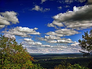
The Pocono Mountains, commonly referred to as the Poconos, are a geographical, geological, and cultural region in Northeastern Pennsylvania. They overlook the Delaware River and Delaware Water Gap to the east, Lake Wallenpaupack to the north, Wyoming Valley and the Coal Region to the west, and the Lehigh Valley to the south. The name Pocono is derived from the Munsee word Pokawachne, which means "Creek Between Two Hills".

<span class="mw-page-title-main">Interstate 380 (Pennsylvania)</span> Highway in Pennsylvania

Interstate 380 (I-380) is an auxiliary Interstate Highway in Northeastern Pennsylvania that connects I-80 with I-81 and I-84. The southern terminus is in Tunkhannock Township at the junction with I-80; the northern terminus of I-380 is at I-81 and U.S. Route 6 (US 6) in Dunmore. The entire length of the highway is 28.45 miles (45.79 km).

<span class="mw-page-title-main">Pennsylvania Route 611</span> State highway in Pennsylvania, United States

Pennsylvania Route 611 is a state highway in eastern Pennsylvania running 109.7 mi (176.5 km) from Interstate 95 (I-95) in the southern part of Philadelphia north to I-380 in Coolbaugh Township in the Pocono Mountains.

<span class="mw-page-title-main">Brodhead Creek</span> River in the United States

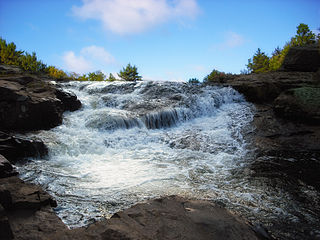
Brodhead Creek is a 21.9-mile-long (35.2 km) tributary of the Delaware River in the Pocono Mountains in Northeastern Pennsylvania.

<span class="mw-page-title-main">Gouldsboro State Park</span> State park in Monroe and Wayne counties, Pennsylvania

Gouldsboro State Park is a 2,880-acre (1,165 ha) Pennsylvania state park in Coolbaugh Township, Monroe County and Lehigh Township, Wayne County, Pennsylvania in the United States. The park includes the 250-acre (100 ha) Gouldsboro Lake. Gouldsboro State Park is located very close to Tobyhanna State Park and Pennsylvania State Game Lands 127 and 312. It is on Pennsylvania Route 507 near the small village of Gouldsboro.

<span class="mw-page-title-main">Pennsylvania Route 447</span> State highway in Pennsylvania, US

Pennsylvania Route 447 (PA 447) is a 26.66-mile-long (42.91 km) north–south state route located in northeast Pennsylvania in the Pocono Mountains. The southern terminus of the route is at U.S. Route 209 (US 209) near an interchange with Interstate 80 (I-80) in Smithfield Township. The northern terminus is at PA 191 and PA 507 in Dreher Township. The route heads northwest from US 209 in Monroe County and forms a brief concurrency with US 209 Business in the northern part of East Stroudsburg. PA 447 continues and forms a concurrency with PA 191 in Analomink before winding north through rural areas. The route bends northwest and crosses PA 390 in Canadensis. PA 447 passes through a section of Pike County before entering Wayne County and reaching its northern terminus.

<span class="mw-page-title-main">East Stroudsburg station</span>

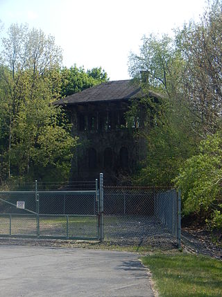
East Stroudsburg is an historic train station built by the Delaware, Lackawanna and Western Railroad in 1856. The station served as the local stop for both East Stroudsburg and Stroudsburg, Pennsylvania. The depot, recently known locally as the Dansbury Depot for the restaurant that used the building, is located on Crystal Street in East Stroudsburg. Service to East Stroudsburg ended on January 6, 1970, when the Erie Lackawanna Railway discontinued the Lake Cities. A proposal is currently in place to extend NJ Transit service to a rebuilt East Stroudsburg station. In spring 2021, Amtrak announced plans for potential New York–Scranton route. It is currently used by some of Steamtown National Historic Site's excursion trains.

<span class="mw-page-title-main">Pocono Mountain station</span>

Pocono Mountain is a proposed New Jersey Transit Rail Operations (NJT) station located in Coolbaugh Township, Monroe County, Pennsylvania and is part of a site that was formerly utilized as a summer camp. The proposed station site, which will include a 1,000-space surface parking lot, is located northwest of a multi-phased planned development for this area. Access will be from Pennsylvania Route 611 via Pocono Municipal Road/Mount Pocono Road and a local access road and the platform would be situated east of the track.

<span class="mw-page-title-main">Lackawanna Cut-Off Restoration Project</span> American railway infrastructure project

The Lackawanna Cut-Off Restoration Project is a New Jersey Transit and Amtrak effort to restore passenger service to the Lackawanna Cut-Off in northwest New Jersey.

<span class="mw-page-title-main">Blairstown station</span>

Blairstown was one of the three original Delaware, Lackawanna and Western Railroad stations on the Lackawanna Cut-Off rail line in northwestern New Jersey. Built by contractor Hyde, McFarlan & Burke, the station opened in 1911. Most passenger trains, such as the Lackawanna Limited and, later, the Phoebe Snow, plus the Twilight/Pocono Express and the Westerner/New Yorker stopped at Blairstown, which also sold commuter tickets.

<span class="mw-page-title-main">Gravel Place, Pennsylvania</span> Former rail yard in Pennsylvania, U.S.

Gravel Place is a location within Arlington Heights, Pennsylvania, about three miles (4.8 km) northeast of East Stroudsburg. It is neither incorporated nor a census-designated place, but has a name recognized by the USGS. From the 1880s to about 1950, it was a railroad yard of the Delaware, Lackawanna and Western Railroad (DL&W) on its mainline from Hoboken Terminal in New Jersey, which served New York City by ferry, to Scranton, Pennsylvania, continuing northwest into New York State with its western terminus in Buffalo, New York. It is just north of present Mill Creek Road.

References

  1. "ArcGIS REST Services Directory". United States Census Bureau. Retrieved October 12, 2022.
  2. 1 2 "Census Population API". United States Census Bureau. Retrieved Oct 12, 2022.
  3. Metropolitan and Micropolitan - Delineation Files - People and Households - U.S. Census Bureau Archived 2013-07-05 at the Wayback Machine
  4. 1 2 "City and Town Population Totals: 2020—2021". Census.gov. US Census Bureau. Retrieved August 6, 2022.
  5. "Stroudsburg and East Stroudsburg founded in the 1730s", Monroe County, retrieved March 6, 2024
  6. "National Register Information System". National Register of Historic Places . National Park Service. July 9, 2010.
  7. "US Gazetteer files: 2010, 2000, and 1990". United States Census Bureau. 2011-02-12. Retrieved 2011-04-23.
  8. "Census of Population and Housing". U.S. Census Bureau. Retrieved 11 December 2013.
  9. "U.S. Census website". United States Census Bureau . Retrieved 2008-01-31.
  10. "East Stroudsburg borough, Pennsylvania". US Census Bureau. Retrieved 2009-07-08.[ dead link ]
  11. "About ESU". East Stroudsburg University. Retrieved 2022-05-02.
  12. "East Stroudsburg Borough map" (PDF). PennDOT. Retrieved March 15, 2023.
  13. Pocono Pony Routes Archived October 5, 2011, at the Wayback Machine
  14. "Final E-L passenger trains pull away from E.S. station". Pocono Record . January 5, 1970. p. 9. Retrieved July 17, 2016 via Newspapers.com. Open Access logo PLoS transparent.svg
  15. New Jersey Transit. Njtransit.com. Retrieved on 2013-08-09.
  16. "New Jersey Transit" . Retrieved 27 April 2016.
  17. Stacy M. Brown, "Pocono Record," May 17, 2016 http://www.poconorecord.com/news/20160517/grants-keep-poconos-to-new-york-commuter-train-moving
  18. 1 2 "USDA Interactive Plant Hardiness Map". United States Department of Agriculture. Archived from the original on July 4, 2019. Retrieved September 3, 2019.
  19. "NowData – NOAA Online Weather Data". National Oceanic and Atmospheric Administration. Retrieved August 9, 2021.
  20. "Station: E Stroudsburg, PA". U.S. Climate Normals 2020: U.S. Monthly Climate Normals (1991–2020). National Oceanic and Atmospheric Administration. Retrieved August 9, 2021.
  21. "U.S. Potential Natural Vegetation, Original Kuchler Types, v2.0 (Spatially Adjusted to Correct Geometric Distortions)" . Retrieved September 3, 2019.