Gouldsboro, Pennsylvania

Last updated

Gouldsboro, Pennsylvania
Village of Gouldsboro
Gouldsboro train station.jpg
Lackawanna Railroad's Gouldsboro Station, which was recently restored, in Gouldsboro, August 2011
Nickname: 
Gouldsboro' [1]
Wayne County Pennsylvania incorporated and unincorporated areas Gouldsboro highlighted.svg
Location in Wayne County and the U.S. state of Pennsylvania.
Country United States
State Pennsylvania
U.S. Congressional Districts PA-10
PA-17
School Districts North Pocono (Region III)
Pocono Mountain (Region III)
Counties Wayne
Monroe
Magisterial Districts 22-3-01 [2]
43-3-01 [3]
Townships Lehigh
Coolbaugh
Settled1871
Named for Jay Gould
Area
  Total3.004 sq mi (7.783 km2)
  Land2.596 [4]  sq mi (6.723 km2)
  Water0.408 [4]  sq mi (1.06 km2)
Elevation
1,909 [5]  ft (582 m)
Population
 (2020)
  Total750 [6]
Time zone UTC−5 (Eastern (EST))
  Summer (DST) UTC−4 (Eastern Daylight (EDT))
ZIP Code
18424 [7]
Area code 570
GNIS feature IDs1175862 [5] (Village)
2631315 [8] (CDP)
FIPS codes 42-127-42432 [9] -30200 [5]
42-089-15960 [10] -30200 [5]
Major Roads PA-507.svg
Waterways Gouldsboro Lake, Larsen Lake, [11] Lake Lehigh, [12] Lehigh River, Lower Klondike Pond, [13] Snag Pond, [14] Lake Watawga, [15] Westend Pond [16]

Gouldsboro is a village and census-designated place (CDP) in Lehigh Township in Wayne County, and Coolbaugh Township, in Monroe County, Pennsylvania, United States. The CDP's population was 750 at time of the 2020 United States Census. [6]

Contents

History

Gouldsboro's Keystone Marker Gouldsboro, PA Keystone Marker.jpg
Gouldsboro's Keystone Marker

Gouldsboro was named for Jay Gould, who built a tannery in the area before becoming famous as a financier. [17]

Geography

According to the United States Census Bureau, Gouldsboro has a total area of 3.004 sq mi (7.783 km2), of which 2.596 sq mi (6.723 km2) is land and 0.408 sq mi (1.06 km2), or 5.72%, is water. [4]

Demographics

Historical population
CensusPop.Note
2010 890
2020 750−15.7%
[18] [6]

As of the Census of 2010, there were 890 people, 353 households, and 253 families in Gouldsboro. The CDP's population density was 343 inhabitants per square mile (132/km2), and there were 546 housing units at an average density of 182/sq mi (70.2/km2). The racial makeup of the populace was 94.9% White, 1.0% African American, 0.1% Native American, 1.3% Asian, 0.1% Pacific Islander, 1.3% of other races, and 1.1% of two or more races. Hispanics and Latinos of all races made up 4.0% of the population. [4] [19]

Of Gouldsboro's households 71.7% were families, 55.8% were headed by a heterosexual married couple (Pennsylvania did not allow same-sex marriage until May 20, 2014, after the 2010 Census had been completed), and 30.3% included children under the age of 18. Of households 10.8% were headed by a female householder with no husband present, 5.1% by a male householder with no wife present, and 28.3% consisted of non-families. Of all households 24.1% were made up of individuals, and 13.3% consisted of a person 65 years of age or older living alone. The average household size was 2.52 and the average family size was 2.95. [19]

Gouldsboro's age distribution was 23.9% under the age of 18, 5.2% between the ages of 18 and 24, 19.9% between 25 and 44, 34.7% between 45 and 64, and 16.3% 65 years of age or older. The population's median age was 45.4 years. For every 100 females, there were 98.7 males. For every 100 females age 18 and over, there were 99.7 males in the same age range. [19]

According to American Community Survey (ACS) estimates, the median income for a household in Gouldsboro in 2013 was $45,469, and the median income for a family was $54,000. Males had a median income of $50,000, while females had a median income of $28,750. The per capita income for the CDP was $27,753. Of families 0.0% and 1.4% of people were below the Census Bureau's poverty thresholds (different from the federally defined poverty guidelines), including 0.0% of those under age 18 and 4.7% of those age 65 or over. [20] [21]

According to self-reported ancestry figures recorded by the ACS, the five largest ancestral groups in Gouldsboro in 2013 were Irish (40.3%), Germans (38.0%), Poles (13.9%), English (13.4%), and Italians (13.3%). Those reporting American ancestry made up 2.5% of the population. [22]

Parks and recreation

Gouldsboro is home to the Gouldsboro State Park. [23] The village is serviced and is within the North Pocono School District.

The former Lackawanna Railroad station houses a railroad museum and is served by excursion trains from Steamtown National Historic Site in nearby Scranton.

The area is extremely scenic and popular with hunters and naturalists. Much of Wayne County's water is under special protection. [24]

Education

The majority of Gouldsboro is in Lehigh Township, and is therefore served primarily by the North Pocono School District, in which it is part of Region III. The small part of the CDP which is contained within Coolbaugh Township, however, is in the Pocono Mountain School District, in which it is also part of Region III.

Postal Service

In addition to parts of the aforementioned Lehigh and Coolbaugh Townships, parts of Clifton, Thornhurst, and Covington Townships in Lackawanna County are serviced by the Gouldsboro Post Office, and are also often referred to as "Gouldsboro".

See also

Related Research Articles

<span class="mw-page-title-main">Wayne County, Pennsylvania</span> County in Pennsylvania

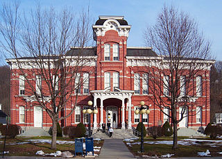
Wayne is a county in the Commonwealth of Pennsylvania. It is part of Northeastern Pennsylvania. The county's population was 51,155 at the 2020 census. The county seat is the Borough of Honesdale. The county was formed from part of Northampton County on March 21, 1798, and was named for the Revolutionary War General Anthony Wayne.

<span class="mw-page-title-main">Saginaw Township North, Michigan</span> Place in Michigan, United States

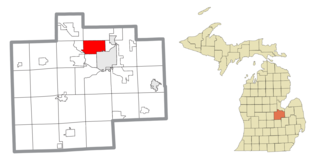
Saginaw Township North is an unincorporated community and former census-designated place (CDP) in Saginaw County in the U.S. state of Michigan. The community is located within Saginaw Charter Township, and the CDP boundaries consisted of most of the northern portion of the township. Saginaw Township South is in the southern portion of the township.

<span class="mw-page-title-main">Shields, Michigan</span> Census-designated place & unincorporated community in Michigan, United States

Shields is an unincorporated community in Thomas Township, Saginaw County in the U.S. state of Michigan. It is also a census-designated place (CDP) for statistical purposes, but with no legal status as an incorporated municipality. The population of the CDP was 7,035 at the 2020 census.

<span class="mw-page-title-main">Wayne Township, Armstrong County, Pennsylvania</span> Township in Pennsylvania, United States

Wayne Township is a township that is located in Armstrong County, Pennsylvania, United States.

<span class="mw-page-title-main">Belmont, Pennsylvania</span> Census-designated place in Pennsylvania, United States

Belmont is an unincorporated community and census-designated place (CDP) in Cambria County, Pennsylvania, United States. The population was 2,784 at the 2010 census.

Dixonville is an unincorporated community in Indiana County, Pennsylvania, United States. The area is recorded as the "Dicksonville" census-designated place (CDP), with a population of 467 at the 2010 census. The CDP lies mostly on the western edge of Green Township, though a small portion extends west into Rayne Township.

<span class="mw-page-title-main">Berlin Township, Wayne County, Pennsylvania</span> Second-class township in Pennsylvania, United States

Berlin Township is a second-class township in Wayne County, Pennsylvania, United States. The township's population was 2,452 at the time of the 2020 United States Census.

<span class="mw-page-title-main">Buckingham Township, Wayne County, Pennsylvania</span> Second-class township in Pennsylvania, United States

Buckingham is a second-class township in Wayne County, Pennsylvania, United States. The township's population was 520 at the time of the 2010 United States Census.

<span class="mw-page-title-main">Cherry Ridge Township, Wayne County, Pennsylvania</span> Second-class township in Pennsylvania, United States

Cherry Ridge is a second-class township in Wayne County, Pennsylvania, United States. The township's population was 1,895 at the time of the 2010 United States Census.

<span class="mw-page-title-main">Clinton Township, Wayne County, Pennsylvania</span> Second-class township in Pennsylvania, United States

Clinton Township is a second-class township in Wayne County, Pennsylvania, United States. The township's population was 2,053 at the time of the 2010 United States Census.

<span class="mw-page-title-main">Damascus Township, Wayne County, Pennsylvania</span> Second-class township in Pennsylvania, United States

Damascus is a second-class township in Wayne County, Pennsylvania, United States. The township's population was 3,659 at the time of the 2010 United States Census.

<span class="mw-page-title-main">Dreher Township, Wayne County, Pennsylvania</span> Second-class township in Pennsylvania, United States

Dreher is a second-class township in Wayne County, Pennsylvania, United States. The township's population was 1,412 at the time of the 2010 United States Census.

<span class="mw-page-title-main">Lake Township, Wayne County, Pennsylvania</span> Second-class township in Pennsylvania, United States

Lake is a second-class township in Wayne County, Pennsylvania, United States. The township's population was 5,269 at the time of the 2010 United States Census.

<span class="mw-page-title-main">Lehigh Township, Wayne County, Pennsylvania</span> Township in Pennsylvania, United States

Lehigh Township is a second-class township in Wayne County, Pennsylvania. The township's population at the 2020 United States Census was 1,876, down slightly from 1,881 at the time of the 2010 United States Census.

<span class="mw-page-title-main">Mount Pleasant Township, Wayne County, Pennsylvania</span> Second-class township in Pennsylvania, United States

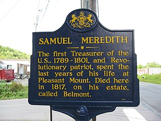
Mount Pleasant is a second-class township in Wayne County, Pennsylvania, United States. The township's population was 1,357 at the time of the 2010 United States Census.

<span class="mw-page-title-main">Preston Township, Pennsylvania</span> Second-class township in Pennsylvania, United States

Preston is a second-class township in Wayne County, Pennsylvania, United States. The township's population was 1,014 at the time of the 2010 United States Census.

<span class="mw-page-title-main">Starrucca, Pennsylvania</span> Borough in Pennsylvania, United States

Starrucca is a borough that is located in Wayne County, Pennsylvania, United States. The borough's population was 173 at the time of the 2010 United States Census.

<span class="mw-page-title-main">Sterling Township, Pennsylvania</span> Township in Pennsylvania, United States

Sterling is a second-class township in Wayne County, Pennsylvania. The township's population was 1,450 at the time of the 2010 United States Census.

<span class="mw-page-title-main">White Mills, Pennsylvania</span> Place in Pennsylvania, United States

White Mills is a village and census-designated place that is located in Texas Township, Wayne County, Pennsylvania, United States. The CDP's population was 659 at the time of the 2010 United States Census.

<span class="mw-page-title-main">Pocono Springs, Pennsylvania</span> Place in Pennsylvania, United States

Pocono Springs is a private community and census-designated place (CDP) in Lehigh and Sterling Townships in Wayne County, Pennsylvania, United States. The CDP's population was 926 at the time of the 2010 United States Census.

References

  1. White, Israel Charles; Dolph, John M. (1881). The Geology of Susquehanna County and Wayne County (Report). Vol. 23. Board of Commissioners for the Second Geological Survey of Pennsylvania. p. 12. Retrieved June 1, 2015.
  2. "District Magistrate". Wayne County, PA. Wayne County Courthouse. 2015. Archived from the original on November 27, 2014. Retrieved June 1, 2015.
  3. "Magisterial District Judges". Monroe County, Pennsylvania. Monroe County, Pennsylvania. 2005. Archived from the original on June 2, 2015. Retrieved June 1, 2015.
  4. 1 2 3 4 2014 Census National Places Gazetteer File for Pennsylvania (Report). U.S. Department of Commerce. 2014. Retrieved June 29, 2015.
  5. 1 2 3 4 "Gouldsboro". Geographic Names Information System . United States Geological Survey, United States Department of the Interior. August 2, 1979. Retrieved June 1, 2015.
  6. 1 2 3 US Census Bureau, 2020 Census Report, Gouldsboro CDP, Pennsylvania Profile https://www.census.gov/search-results.html?searchType=web&cssp=SERP&q=Gouldsboro%20CDP,%20Pennsylvania
  7. "Look up a ZIP Code". USPS.COM. USPS. 2015. Retrieved June 1, 2015.
  8. "Gouldsboro Census Designated Place". Geographic Names Information System. United States Geological Survey. August 30, 2010. Retrieved June 1, 2015.
  9. U.S. Census Bureau. Census 2000. "Census Demographic Profiles, Lehigh Township" (PDF). CenStats Databases. Retrieved June 1, 2015.{{cite web}}: CS1 maint: numeric names: authors list (link)[ dead link ]
  10. U.S. Census Bureau. Census 2000. "Census Demographic Profiles, Coolbaugh Township" (PDF). CenStats Databases. Retrieved June 1, 2015.{{cite web}}: CS1 maint: numeric names: authors list (link)[ dead link ]
  11. "Larsen Lake". Geographic Names Information System. United States Geological Survey. August 30, 1990. Retrieved June 1, 2015.
  12. "Lake Lehigh". Geographic Names Information System. United States Geological Survey. August 30, 1990. Retrieved June 1, 2015.
  13. "Lower Klondike Pond". Geographic Names Information System. United States Geological Survey. August 2, 1979. Retrieved June 1, 2015.
  14. "Snag Pond". Geographic Names Information System. United States Geological Survey. August 2, 1979. Retrieved June 1, 2015.
  15. "Lake Watawga". Geographic Names Information System. United States Geological Survey. August 2, 1979. Retrieved June 1, 2015.
  16. "Westend Pond". Geographic Names Information System. United States Geological Survey. August 2, 1979. Retrieved June 1, 2015.
  17. "Gouldsboro Train Station". Wayne County Historical Society. Retrieved January 23, 2018.
  18. Profile of General Population and Housing Characteristics: 2010 Demographic Profile Data for Gouldsboro, Pennsylvania (Report). U.S. Department of Commerce. 2010. Archived from the original on February 13, 2020. Retrieved June 5, 2015.
  19. 1 2 3 Profile of General Population and Housing Characteristics: 2010 Demographic Profile Data for Gouldsboro, Pennsylvania (Report). U.S. Department of Commerce. 2010. Archived from the original on February 13, 2020. Retrieved June 5, 2015.
  20. Selected Economic Characteristics 2009–2013 American Community Survey 5-Year Estimates for Gouldsboro, Pennsylvania (Report). U.S. Department of Commerce. 2013. Archived from the original on February 13, 2020. Retrieved June 5, 2015.
  21. Occupation by Sex and Median Earnings in the Past 12 Months (In 2013 Inflation-Adjusted Dollars) For the Civilian Employed Population 16 Years and Over 2009–2013 American Community Survey 5-Year Estimates for Gouldsboro, Pennsylvania (Report). U.S. Department of Commerce. 2013. Archived from the original on February 13, 2020. Retrieved June 5, 2015.
  22. Selected Social Characteristics in the United States 2009–2013 American Community Survey 5-Year Estimates for Gouldsboro, Pennsylvania (Report). U.S. Department of Commerce. 2013. Archived from the original on February 13, 2020. Retrieved June 29, 2015.
  23. "Gouldsboro State Park". Pennsylvania Department of Conservation and Natural Resources. Commonwealth of Pennsylvania. 2009. Archived from the original on April 22, 2014. Retrieved June 5, 2015.
  24. "Special Protection Waters". Wayne County Planning Commission / GIS. Wayne County Courthouse. Archived from the original on June 12, 2015. Retrieved June 5, 2015.