Paupack Township, Pennsylvania

Last updated

Paupack Township
Lake Wallenpaupack - panoramio (1).jpg
Wayne County Pennsylvania incorporated and unincorporated areas Paupack township highlighted.svg
Location in Wayne County and the state of Pennsylvania.
Pennsylvania in United States (US48).svg
Location of Pennsylvania in the United States
Coordinates: 41°27′00″N75°15′59″W / 41.45000°N 75.26639°W / 41.45000; -75.26639
CountryUnited States
StatePennsylvania
County Wayne
Area
[1]
  Total33.15 sq mi (85.84 km2)
  Land28.01 sq mi (72.55 km2)
  Water5.13 sq mi (13.30 km2)
Elevation
1,417 ft (432 m)
Population
 (2010)
  Total3,828
  Estimate 
(2016) [2]
3,690
  Density131.74/sq mi (50.86/km2)
Time zone UTC-5 (EST)
  Summer (DST) UTC-4 (EDT)
Area code 570
FIPS code 42-127-58480
Website Paupack Township

Paupack is a second-class township in Wayne County, Pennsylvania, United States. The township's population was 3,828 at the time of the 2010 United States Census. [3]

Contents

History

Paupack Township, located along the northern banks of Lake Wallenpaupack, was incorporated in 1850, from part of Palmyra Township.

Lacawac was listed on the National Register of Historic Places in 1979. [4]

Geography

According to the United States Census Bureau, the township has a total area of 33.2 square miles (86.0 km2), of which 28.1 square miles (72.8 km2) is land and 5.1 square miles (13.2 km2) (15.36%) is water.

Demographics

Historical population
CensusPop.Note
2010 3,828
2016 (est.)3,690 [2] −3.6%
U.S. Decennial Census [5]

As of the census of 2010, there were 3,828 people, 1,643 households, and 1,172 families residing in the township. The population density was 136.2 inhabitants per square mile (52.6/km2). There were 4,030 housing units at an average density of 143.4/sq mi. The racial makeup of the township was 97.3% White, 1.1% African American, 0.1% Native American, 0.4% Asian, 0.4% from other races, and 0.7% from two or more races. Hispanic or Latino of any race were 3.4% of the population.

There were 1,643 households, out of which 20.1% had children under the age of 18 living with them, 58.2% were married couples living together, 9.6% had a female householder with no husband present, and 28.7% were non-families. 23.5% of all households were made up of individuals, and 11.1% had someone living alone who was 65 years of age or older. The average household size was 2.33 and the average family size was 2.71.

In the township the population was spread out, with 17.1% under the age of 18, 58.2% from 18 to 64, and 24.7% who were 65 years of age or older. The median age was 51.1 years.

The median income for a household in the township was $38,179, and the median income for a family was $41,336. Males had a median income of $31,223 versus $21,757 for females. The per capita income for the township was $18,251. About 7.1% of families and 9.3% of the population were below the poverty line, including 14.1% of those under age 18 and 4.6% of those age 65 or over.

Related Research Articles

<span class="mw-page-title-main">Pike Bay Township, Cass County, Minnesota</span> Township in Minnesota, United States

Pike Bay Township is a township in Cass County, Minnesota, United States. The population was 1,643 as of the 2000 census. Pike Bay Township was named for Pike Bay of Cass Lake, and indirectly for Zebulon Pike, an explorer.

Alvwood Township is a township in Itasca County, Minnesota, United States. The population was 42 at the 2010 census.

Blackberry Township is a township in Itasca County, Minnesota, United States. The population was 827 at the 2020 census.

Good Hope Township is a township in Itasca County, Minnesota, United States. The population was 99 at the 2010 census.

<span class="mw-page-title-main">East Freehold, New Jersey</span> Populated place in Monmouth County, New Jersey, US

East Freehold is an unincorporated community and census-designated place (CDP) located within Freehold Township, in Monmouth County, in the U.S. state of New Jersey. As of the 2010 United States Census, the CDP's population was 4,894.

<span class="mw-page-title-main">Sandusky South, Ohio</span> Census-designated place in Ohio, United States

Sandusky South is an census-designated place in Perkins Township, Erie County, Ohio, United States. The population was 6,599 at the 2000 census. It was not delineated as a CDP for the 2010 census. It is part of the Sandusky, Ohio Metropolitan Statistical Area.

<span class="mw-page-title-main">Londonderry Township, Bedford County, Pennsylvania</span> Township in Pennsylvania, United States

Londonderry Township is a township in Bedford County, Pennsylvania, United States. It is named after County Londonderry, now in Northern Ireland. The population was 1,643 at the 2020 census.

<span class="mw-page-title-main">Glenburn Township, Lackawanna County, Pennsylvania</span> Place in Pennsylvania, United States

Glenburn Township is a township in Lackawanna County, Pennsylvania, founded in 1877. The population was 1,441 at the 2020 census.

<span class="mw-page-title-main">Spring Brook Township, Pennsylvania</span> Place in Pennsylvania, United States

Spring Brook Township is a township in Lackawanna County, Pennsylvania, United States. The population was 2,753 at the 2020 census.

<span class="mw-page-title-main">Union Township, Schuylkill County, Pennsylvania</span> Township in Pennsylvania, United States

Union Township is a township that is located in Schuylkill County, Pennsylvania, United States. The population was 1,231 at the time of the 2020 census.

<span class="mw-page-title-main">Apolacon Township, Pennsylvania</span> Township in Pennsylvania, United States

Apolacon Township is a township in Susquehanna County, Pennsylvania, United States. The population was 425 at the 2020 census.

<span class="mw-page-title-main">Lathrop Township, Susquehanna County, Pennsylvania</span> Township in the United States

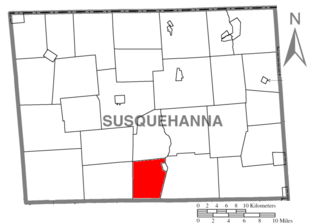
Lathrop Township is a township in Susquehanna County, Pennsylvania, United States. The population was 771 at the 2020 census.

<span class="mw-page-title-main">Carroll Township, Washington County, Pennsylvania</span> Township in Pennsylvania, United States

Carroll Township is a township in Washington County, Pennsylvania, United States. The population was 5,381 at the 2020 census.

<span class="mw-page-title-main">Roscoe, Pennsylvania</span> Borough in Pennsylvania, United States

Roscoe is a borough in Washington County, Pennsylvania, United States. The population was 716 at the 2020 census.

<span class="mw-page-title-main">Oregon Township, Pennsylvania</span> Township in Pennsylvania, United States

Oregon is a second-class township in Wayne County, Pennsylvania, United States. The township's population was 781 at the time of the 2010 United States Census.

<span class="mw-page-title-main">Palmyra Township, Wayne County, Pennsylvania</span> Township in Pennsylvania, United States

Palmyra is a second-class township in Wayne County, Pennsylvania. The township's population was 1,339 at the time of the 2010 United States Census.

<span class="mw-page-title-main">Braintrim Township, Pennsylvania</span> Township in Pennsylvania, United States

Braintrim Township is a township in Wyoming County, Pennsylvania, United States. The population was 460 at the 2020 census.

<span class="mw-page-title-main">Mehoopany Township, Pennsylvania</span> Township in Pennsylvania, United States

Mehoopany Township is a township in Wyoming County, Pennsylvania, United States. The population was 896 at the 2020 census.

<span class="mw-page-title-main">Wynnedale, Indiana</span> Town in Indiana, United States

Wynnedale is a town in Washington Township, Marion County, Indiana, United States. The population was 215 at the 2020 census. It has existed as an "included town" since 1970, when it was incorporated into Indianapolis as part of Unigov. It is part of Indianapolis, but retains a functioning town government under IC 36-3-1-11.

<span class="mw-page-title-main">Wallenpaupack Lake Estates, Pennsylvania</span> Place in Pennsylvania, United States

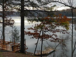
Wallenpaupack Lake Estates is a private community and census-designated place in Paupack Township, Wayne County in the U.S. State of Pennsylvania. The community's population was 1,279 as of the 2010 United States Census.

References

  1. "2016 U.S. Gazetteer Files". United States Census Bureau. Retrieved August 14, 2017.
  2. 1 2 "Population and Housing Unit Estimates" . Retrieved June 9, 2017.
  3. "U.S. Census website". United States Census Bureau . Retrieved May 14, 2011.
  4. "National Register Information System". National Register of Historic Places . National Park Service. July 9, 2010.
  5. "Census of Population and Housing". Census.gov. Retrieved June 4, 2016.