Eastlawn Gardens, Pennsylvania

Last updated

Eastlawn Gardens
USA Pennsylvania location map.svg
Red pog.svg
Eastlawn Gardens
Location of Eastlawn Gardens in Pennsylvania
Usa edcp location map.svg
Red pog.svg
Eastlawn Gardens
Eastlawn Gardens (the United States)
Coordinates: 40°44′57″N75°17′55″W / 40.74917°N 75.29861°W / 40.74917; -75.29861
Country Flag of the United States.svg  United States
State Flag of Pennsylvania.svg  Pennsylvania
County Northampton
Area
  City4 km2 (1.7 sq mi)
  Land4 km2 (1.7 sq mi)
  Water0.1 km2 (0.04 sq mi)
Elevation
143 m (469 ft)
Population
 (2010)
  City3,307
  Density750/km2 (1,900/sq mi)
   Metro
865,310 (US: 68th)
Time zone UTC-5 (EST)
  Summer (DST) UTC-4 (EDT)
Area code(s) 610

Eastlawn Gardens is a census-designated place (CDP) in Upper Nazareth Township in Northampton County, Pennsylvania, United States. The population of Eastlawn Gardens was 3,307 at the 2010 census. Eastlawn Gardens is part of the Lehigh Valley metropolitan area, which had a population of 861,899 and was the 68th-most populous metropolitan area in the U.S. as of the 2020 census.

Contents

Geography

Eastlawn Gardens is located at 40°44′57″N75°17′55″W / 40.74917°N 75.29861°W / 40.74917; -75.29861 (40.749065, -75.298750). [1] According to the U.S. Census Bureau, Eastlawn Gardens has a total area of 1.7 square miles (4.4 km2), of which 1.7 square miles (4.4 km2) is land and 0.04 square miles (0.10 km2) (1.20%) is water.

Demographics

As of the census [2] of 2000, there were 2,832 people, 1,010 households, and 804 families residing in the CDP. The population density was 1,709.6 inhabitants per square mile (660.1/km2). There were 1,028 housing units at an average density of 620.6 per square mile (239.6/km2). The racial makeup of the CDP was 97.81% White, 0.28% African American, 0.18% Native American, 0.53% Asian, 0.74% from other races, and 0.46% from two or more races. Hispanic or Latino of any race were 1.41% of the population.

There were 1,010 households, out of which 42.9% had children under the age of 18 living with them, 69.2% were married couples living together, 8.0% had a female householder with no husband present, and 20.3% were non-families. 16.6% of all households were made up of individuals, and 9.0% had someone living alone who was 65 years of age or older. The average household size was 2.80 and the average family size was 3.17.

In Eastlawn Gardens, the population was spread out, with 28.9% under the age of 18, 4.7% from 18 to 24, 32.3% from 25 to 44, 20.0% from 45 to 64, and 14.2% who were 65 years of age or older. The median age was 37 years. For every 100 females, there were 97.6 males. For every 100 females age 18 and over, there were 93.1 males. The median income for a household in the CDP was $56,855, and the median income for a family was $62,969. Males had a median income of $43,688 versus $27,276 for females. The per capita income for the CDP was $23,985. About 0.8% of families and 1.9% of the population were below the poverty line, including 3.0% of those under age 18 and none of those age 65 or over.

Education

The community is served by the Nazareth Area School District. Students in grades nine through 12 attend Nazareth Area High School in Nazareth.

Related Research Articles

<span class="mw-page-title-main">Littletown, Arizona</span> CDP in Pima County, Arizona

Littletown was a census-designated place (CDP) in Pima County, Arizona, United States. The population was 1,010 at the 2000 census. The area was annexed into Tucson in 2017.

<span class="mw-page-title-main">Winter Gardens, California</span> Census-designated place in California, United States

Winter Gardens is a census-designated place (CDP) in San Diego County, California. The population was 20,631 at the 2010 census, up from 19,771 at the 2000 census.

<span class="mw-page-title-main">West Pocomoke, Maryland</span> CDP in Maryland, United States

West Pocomoke is a census-designated place (CDP) in Somerset County, Maryland, United States. The population was 498 at the 2000 census. It is included in the Salisbury, Maryland-Delaware Metropolitan Statistical Area.

<span class="mw-page-title-main">Paramount-Long Meadow, Maryland</span> CDP in Maryland, United States

Paramount-Long Meadow is a census-designated place (CDP) in Washington County, Maryland, United States. The population was 2,722 at the 2000 census.

<span class="mw-page-title-main">Leisure Knoll, New Jersey</span> Populated place in Ocean County, New Jersey, US

Leisure Knoll is an unincorporated community and census-designated place (CDP) located within Manchester Township, in Ocean County, in the U.S. state of New Jersey. As of the 2010 United States Census, the CDP's population was 2,490.

<span class="mw-page-title-main">Garden City Park, New York</span> Hamlet and census-designated place in New York, United States

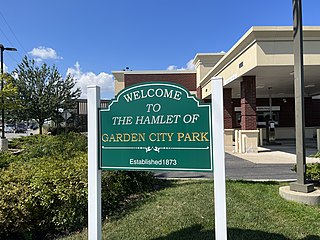
Garden City Park is a hamlet and census-designated place (CDP) located in the Town of North Hempstead in Nassau County, on Long Island, in New York, United States. The population was 7,806 at the 2010 census.

<span class="mw-page-title-main">Wetherington, Ohio</span> Census-designated place in Ohio, United States

Wetherington is a census-designated place (CDP) in West Chester Township, Butler County, Ohio, United States. The population was 1,381 at the 2020 census.

<span class="mw-page-title-main">Garden Home–Whitford, Oregon</span> CDP in Oregon, United States

Garden Home-Whitford is a census-designated place (CDP) consisting of the neighborhoods of Garden Home and the smaller Whitford area in Washington County, Oregon, United States. They are located in the southwest hills of Portland, near Beaverton. As of the 2020 census, the CDP population was 7,081.

Amity Gardens is a census-designated place (CDP) in Amity Township, Berks County, Pennsylvania. As of the 2020 census, the CDP had a total population of 3,715. The town lends its name to a Fountains of Wayne song.

<span class="mw-page-title-main">Tresckow, Pennsylvania</span> Census-designated place in Pennsylvania, United States

Tresckow, formerly known as Dutchtown, is an unincorporated community and census-designated place (CDP) in Carbon County, Pennsylvania, United States. It is part of Northeastern Pennsylvania and is located west of Junedale and Beaver Meadows, which share the same road network. The community has deep roots in the anthracite coal mining and transportation industries.

<span class="mw-page-title-main">Kenilworth, Pennsylvania</span> Census-designated place in Pennsylvania, United States

Kenilworth is a census-designated place (CDP) in North Coventry Township, Chester County, Pennsylvania, United States. The population was 2,148 at the 2020 census.

Ancient Oaks is a census-designated place (CDP) in Lower Macungie Township in Lehigh County, Pennsylvania, United States. It is named after the housing subdivision named Ancient Oaks, located off PA Route 100 just north of Macungie. The population of Ancient Oaks was 6,995 at the 2020 census.

Halfway House is a census-designated place (CDP) in Montgomery County, Pennsylvania, United States. The population was 3,273 at the 2020 census.

<span class="mw-page-title-main">Sanatoga, Pennsylvania</span> Census-designated place in Pennsylvania, United States

Sanatoga is a community and census-designated place (CDP) that is located in Lower Pottsgrove Township, Montgomery County, Pennsylvania, United States. It is situated immediately east of the borough of Pottstown on U.S. Route 422.

<span class="mw-page-title-main">Spring House, Pennsylvania</span> Census-designated place in Pennsylvania, United States

Spring House is a census-designated place (CDP) in Lower Gwynedd Township, Montgomery County, Pennsylvania, United States. The population was 3,978 at the 2020 census.

<span class="mw-page-title-main">Stowe, Pennsylvania</span> Census-designated place in Pennsylvania, United States

Stowe is a census-designated place (CDP) in West Pottsgrove Township, Montgomery County, Pennsylvania, United States. The population was 3,695 at the 2010 census. It uses the Pottstown ZIP code of 19464.

<span class="mw-page-title-main">Upper Nazareth Township, Pennsylvania</span> Place in Pennsylvania, United States

Upper Nazareth Township is a township in Northampton County, Pennsylvania, United States. It is part of the Lehigh Valley metropolitan area, which had a population of 861,899 and was the 68th-most populous metropolitan area in the U.S. as of the 2020 census. At the 2010 census, Upper Nazareth Township's population was 6,231.

<span class="mw-page-title-main">Lake Wynonah, Pennsylvania</span> CDP in Pennsylvania, United States

Lake Wynonah is a census-designated place (CDP) in Schuylkill County, Pennsylvania, United States. The population was 1,961 at the 2000 census, and 2,640 at the 2010 census. Lake Wynonah is a gated community with two lakes, Fawn Lake and Lake Wynonah, and as of July 2008, there are over 1200 homes and 1500 members. It is in South Manheim and Wayne Townships.

<span class="mw-page-title-main">Grantley, Pennsylvania</span> CDP in Pennsylvania, United States

Grantley is a census-designated place (CDP) in York County, Pennsylvania, United States. The population was 3,628 at the 2010 census.

<span class="mw-page-title-main">Milam, Texas</span> CDP in Texas, United States

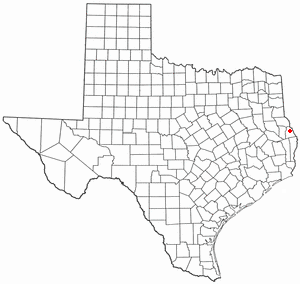
Milam is a census-designated place (CDP) in Sabine County, Texas, United States. It is located along the Sabine River at the junction of Highway 87 and Highway 21. The population was 1,355 at the 2020 census. Milam is the largest city in Sabine County.

References

  1. "US Gazetteer files: 2010, 2000, and 1990". United States Census Bureau. February 12, 2011. Retrieved April 23, 2011.
  2. "U.S. Census website". United States Census Bureau . Retrieved January 31, 2008.