Beckenham is a town in Greater London, England, within the London Borough of Bromley. Prior to 1965, it was part of Kent. It is situated north of Elmers End and Eden Park, east of Penge, south of Lower Sydenham and Bellingham, and west of Bromley and Shortlands, and 8.4 miles (13.5 km) south-east of Charing Cross. Its population at the 2011 Census was 46,844.

Bellingham is an area of South East London, England, within the London Borough of Lewisham. It lies south of Catford, east of Sydenham and north of Beckenham, and is part of the Catford postal district (SE6).

Crystal Palace is in South London, and named after the Crystal Palace Exhibition building which stood in the area from 1854, until it was destroyed by fire in 1936. About 7 miles (11 km) southeast of Charing Cross, it includes one of the highest points in London, at 367 feet (112 m), offering views over the capital.

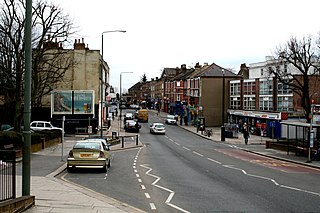
Penge is a suburb of South East London, England, now in the London Borough of Bromley, 3.5 miles (5.6 km) west of Bromley, 3.7 miles (6.0 km) north east of Croydon and 7.1 miles (11.4 km) south east of Charing Cross.

Sydenham is a district of south-east London, England, which is shared between the London boroughs of Lewisham, Bromley and Southwark. Prior to the creation of the County of London in 1889, Sydenham was located in Kent, bordering Surrey. Historically, the area was very affluent, with the Crystal Palace being relocated to Sydenham Hill in 1854. Today, Sydenham is a diverse area, with a population of 28,378 and borders Forest Hill, Dulwich, Crystal Palace, Penge, Beckenham, Catford and Bellingham.
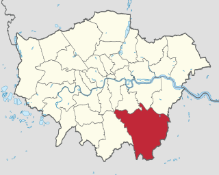
The London Borough of Bromley is the largest and southeasternmost of the London boroughs that make up Greater London, bordering the county of Kent, which most of Bromley was part of before 1965. The borough's population in the 2021 census was 329,991. It is named after Bromley, its principal town; other major towns are Penge, Hayes, West Wickham, Chislehurst, Beckenham and Orpington. The local authority is Bromley London Borough Council.

Langley Park School for Boys is a boys secondary academy school in Beckenham in the London Borough of Bromley, with a co-ed sixth form. On 31 March 2011, the school converted from a Foundation School to an academy and its current status is that of an "Academy Converter".

Birkbeck is a railway station and light rail stop in the London Borough of Bromley in the southern suburbs of London. On the rail network it is 10 miles 26 chains (16.6 km) measured from London Victoria. It is located on Elmers End Road (A214) and alongside Beckenham Crematorium.

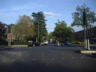
The Chinese Garage is a former garage and petrol station situated in Beckenham in the London Borough of Bromley, on a roundabout linking Beckenham, Eden Park and Shortlands. Built in 1928 to a Japanese pagoda style design by Edmund B. Clarke, it was voted the most unusual garage in England in 2001. It currently hosts a Tesco Express and Majestic Wine store.

West Wickham is an area of South East London, England, in the London Borough of Bromley. It lies south of Park Langley,Eden Park Beckenham and Bromley town center, west of Hayes and north of Coney Hall, east of Spring Park and Shirley. 10.3 miles (16.6 km) south-east of Charing Cross on the line of a Roman road, the London to Lewes Way. Before the creation of Greater London in 1965, West Wickham was in Kent.

Monks Orchard is a suburb on the edge of the London Borough of Croydon, in the ceremonial county of Greater London, England, priot to 1965 it was located in the historical county of Surrey. It is situated about 10 miles (16.1 km) south south-east of Charing Cross, south of Elmers End and Eden Park, west of West Wickham, and north and east of Shirley and Shirley Oaks.

Eden Park railway station serves Eden Park in the London Borough of Bromley in south east London, in Travelcard Zone 5. It is therefore possible to use an Oyster card at the station. It is 12 miles 34 chains (20.0 km) down the line from London Charing Cross. The station and all trains serving it is operated by Southeastern on the Hayes line. The trains are electric, powered by a third rail.

Penge East railway station is on the Chatham Main Line in England, serving part of the Penge and Sydenham areas in the London Borough of Bromley, south London. It is 7 miles 15 chains (11.6 km) down the line from London Victoria and is situated between Sydenham Hill and Kent House.

Sydenham Hill railway station is on the Chatham Main Line in England, serving Sydenham Hill, the Kingswood Estate, and Upper Sydenham, in south London. It is 5 miles 57 chains (9.2 km) down the line from London Victoria and is situated between West Dulwich and Penge East. The station and all trains that call are operated by Southeastern, as part of the Bromley South Metro service. Sydenham Hill is in Travelcard Zone 3.

Beckenham was a local government district in north west Kent from 1878 to 1965 around the town of Beckenham. The area was suburban to London, formed part of the Metropolitan Police District and from 1933 was included in the area of the London Passenger Transport Board.
Anerley is an area of south east London, England, within the London Borough of Bromley. It is located 7 miles (11 km) south south-east of Charing Cross, to the south of Crystal Palace and Upper Norwood, west of Penge, north of Elmers End and South Norwood.
Shortlands is a suburb of South East London, England, within the London Borough of Bromley. It has been part of Greater London since 1965, and was previously part of the historic county of Kent. It is located between west of Bromley and east of Beckenham.
Park Langley is a suburb of South-East London, located in the London Borough of Bromley, Greater London and prior to 1965, in the historic county of Kent. It borders Shortlands and Beckenham to the north, Bromley to the east, Hayes and West Wickham to the south, and Eden Park to the west.

The Mid-Kent line is a British railway line running from Courthill Loop North junction to Hayes railway station in the London Borough of Bromley. Despite its name, none of the line is in the present-day county of Kent.

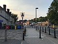
Elmers End is an area of south-east London, England, within the London Borough of Bromley, Greater London and formerly part of the historic county of Kent. It is located south of Beckenham, west of Eden Park, north of Monks Orchard and east of Anerley.