Keston

Last updated

Keston
Keston Pondsby.jpg
Keston Pond
Greater London UK location map 2.svg
Red pog.svg
Keston
Location within Greater London
OS grid reference TQ415645
London borough
Ceremonial county Greater London
Region
Country England
Sovereign state United Kingdom
Post town KESTON
Postcode district BR2
Dialling code 01689
Police Metropolitan
Fire London
Ambulance London
UK Parliament
London Assembly
List of places
UK
England
London
51°21′45″N0°01′38″E / 51.3625°N 0.0271°E / 51.3625; 0.0271

Keston is a village in Greater London, England, located within the London Borough of Bromley, Greater London. Prior to 1965 it was within the historic county of Kent. It is part suburban, part rural in nature and lies on the edge of Hayes Common, just beyond the London conurbation to the south of Bromley Common. It includes the small hamlet of Nash to the southwest. The northern, more suburban part of Keston is sometimes referred to as Keston Mark.

Contents

History

One of the tombs at the Roman Mausoleum in Keston Keston Roman Mausoleum as seen from the West.jpg
One of the tombs at the Roman Mausoleum in Keston

Flint implements and pit dwellings on Keston and Hayes Commons show occupation of the area back to at least 3000 B.C., and there are Iron Age encampments in Holwood Park and on Keston Common. [1]

In the valley below the village are the ruins of a complex of 3rd century AD Roman tombs and mausolea ( 51°21′04″N0°01′48″E / 51.3511068°N 0.0299549°E / 51.3511068; 0.0299549 ) connected with the nearby 1st - 4th century AD Roman villa excavated 1967-1992 ( 51°21′02″N0°01′44″E / 51.3506679°N 0.0287962°E / 51.3506679; 0.0287962 ). [2] [3]

Sited closer to the original Keston Court than the main village itself, Keston's small medieval church is unusual in that does not have a dedication to a saint; but built into the altar-table is the top of the 17th-century altar inlaid with a very elaborate cross and inscribed "The Keston Marke: IN HOC SIGNO VINCES", so the parish has a distinctive symbol instead. [4]

The slavery abolitionist William Wilberforce was a frequent visitor to the area as his close friend, the Prime Minister William Pitt the Younger, lived at Holwood Park. It was on top of the vale of Keston near to an oak tree that he discussed the abolition of slavery with his friend, Pitt. Only the partial dead remains of the 'Wilberforce oak' are left, but a new oak tree has been planted in its place. A stone bench, 'Wilberforce seat', commemorating the event, now marks the spot and bears the inscription from his diary "Just above a steep descent into the vale of Keston, I resolved to give notice ... in the House of Commons of my intention to bring forward the abolition of the Slave Trade."

Holwood was described in Pitt's time as " a small, neat, white building; it is more simple than elegant". [5] Pitt engaged John Soane to enlarge the house and Humphry Repton to improve the grounds. Soane's house burnt down, and was rebuilt in 1823-6 for John Ward in a Grecian style by Decimus Burton. The new house was on a larger scale than Pitt's, in white brick and Portland stone. [6] Later owners included Lord Chancellor Cranworth, the Earl of Derby, and Seismograph Service Ltd.

The Wilberforce Seat The Wilberforce Seat at Keston Common.jpg
The Wilberforce Seat

The Keston Institute, now at Oxford, was so named because for some years from the early 1970s it was located (as Keston College) in the former parish school on Keston Common. [7] Its archive is at the Keston Centre for Religion Politics and Society at Baylor University, Texas, so the parish's name has spread surprisingly far.

There was historically a small hamlet situated to the north-east of Keston village, at the junction of Croydon Road and Westerham Road/Oakley Road; it was called Keston Mark as it lay on the border ('march' or 'mark') of Keston proper. [3] This area was more heavily developed in the 20th century, and it now effectively forms a suburban continuation of Locksbottom and Bromley Common. [3]

Keston Park

Keston Park is a gated community covering an area of approximately 140 acres (0.57 km2) with approximately 200 residential properties. [8] It is bounded by Westerham Road to the west, Croydon Road to the north and Farnborough Common to the north east. The land on which the Park stands was part of the Holwood Estate owned by the Earl of Derby.

Its most famous past resident is former prime minister Margaret Thatcher who with her late husband Denis raised their children, Mark and Carol.[ citation needed ] Others residents include Rolling Stone, Bill Wyman, Arsenal and England footballer, Kenny Sansom, founder of Direct Line, Peter Wood and some of the YouTube stars KSI, Miniminter, Vikkstar123 and Zerkaa, who are part of the YouTube supergroup SIDEMEN .[ citation needed ], Nobel Prize winner for medicine Sir John Vane, chef Gary Rhodes, founder of Pimlico Plumbers Charlie Mullins, Tennis Player and TV Presenter Annabelle Croft.

History

When Frederick Rogers bought 143 acres (0.58 km2) of land from the Earl of Derby on 9 January 1923 for £6000, it was for the purpose of developing Keston Park. [9]

Keston village sign Keston Village Sign (I).jpg
Keston village sign

The land was formerly known as the Keston Lodge Estate. Keston Lodge was the dower house to Holwood House and was occupied by Lady Ashton. It was probably regarded at the time as a separate part of the Holwood Estate and was divided from it by the public footpath which runs from Farnborough Common, almost opposite Hilda Vale Road, to Westerham Road, near to Fishponds Road.

Keston Lodge (not to be confused with a property of the same name, which stood on the opposite side of Croydon Road and is now occupied by houses in the vicinity of Cedar Crescent) later became the Keston Park Hotel. It was taken down in the 1960s. The site is now developed as Keston Park Close. The stables of the old Keston Lodge remained until the late 1970s when they too were demolished to make way for three new houses in Forest Ridge. Keston Lodge was approached through the present entrance to Forest Ridge/Forest Drive on Croydon Road. The drive ran up the line of Forest Ridge, curving back around the stables to the left to come out in front of the south side of the house. An unfenced road is shown on early maps on the line of the present Forest Drive, and this was probably the main link between Keston Lodge and Holwood House.

Holwood Park Avenue lies on the line of the north carriageway from Holwood House. According to some early maps the north carriageway was used as the principal entrance to Holwood House. There was a further access onto Croydon Road and another lodge house at Poynters Lodge near Gap House. Access is now gained to Holwood House along the west carriageway which comes out into Westerham Road at Bowens Lodge.

As well as Holwood House (built in the 1750s, [9] Grade II listed and now called Holwood Mansion) [10] and the old lodges, there are still some physical remains of the Keston Lodge Estate. There are also three fishponds on Keston Common, adjacent to Fishponds Road. The ponds were constructed in the early 19th century to provide a water supply to Holwood House, and are now part of popular recreational area and part of Keston Common.

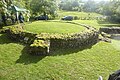
Jesmond Cottage, now renamed Bushwood at 30 Forest Drive, is older than the rest of the houses on the Park. Close behind it are the walls of the old kitchen garden and greenhouses which used to serve the estate. The garden and greenhouses covered a substantial area and incorporated two ponds in the run of the stream between Forest Drive and Forest Ridge.

Further west is the old pavilion, which dates from the time when the lower part of Longdon Wood was a cricket ground.

River Ravensbourne

Caesar's Well, the source of the River Ravensbourne. Caesars Well - geograph.org.uk - 870051.jpg
Caesar's Well, the source of the River Ravensbourne.

The River Ravensbourne rises at Caesar's Well via Keston Ponds. The Ravensbourne is 11 miles (17.4 km) in length and flows through the London Boroughs of Bromley, Lewisham and Greenwich. Since 1991, Quaggy Waterways Action Group (QWAG) have spent millions maintaining the River Ravensbourne. The "London LOOP" walk passes the ponds on its way from Farnborough to West Wickham. Every year on 1 May at 5.32am, the Ravensbourne Morris Men dance up the Beltane Sunrise at Caesar's Well, the source of the Ravensbourne River. [11]

Public Houses

The Ravensbourne Morris Men dance outside the Greyhound pub in Keston each Boxing Day (photographed here in 2023) 2023 Boxing Day Morris Dance at Keston (24).jpg
The Ravensbourne Morris Men dance outside the Greyhound pub in Keston each Boxing Day (photographed here in 2023)

Following the conversion of the Keston Mark to residential accommodation, Keston has three pubs. The Two Doves in Oakley Road lies between the village and Bromley Common, with the remaining two being in the village itself and within sight of each other; The Fox Inn on Heathfield Road and the Greyhound on Commonside. The latter is well-known locally as the venue for the Boxing Day performance of the local Morris Dancing side, the Ravensbourne Morris Men who have performed there, collecting for charity, since a visit in 1963 to Keston by Richard Chamberlain.[ citation needed ]

Windmills

Keston Windmill Keston Windmill (I).jpg
Keston Windmill

Keston has had three windmills over the centuries: the post mill built in 1716 that still stands on Keston Common, a smock mill known as Olive's Mill, built in 1824 and burnt down between 1878 and 1885, and a third mill, which stood at Holwood Park. [12] [13]

St. Audrey's

A small private church dedicated to St. Audrey was built by Lord Sackville Cecil, son of the Marquess of Salisbury, on the site of Olive's Mill in 1889. The church and other mill premises came into the possession of the parish in 1908, and since 1925 the former Olive's Mill House has been used as the rectory. (The former rectory, next to the parish church, was sold off as it was deemed too large, and was later bombed in the Second World War). The mill buildings were for nearly a century used as parish rooms. [14] The church has now been secularised.

Transport

Rail

The nearest railway station to Keston is Hayes, the terminus of the Hayes line, some 1.6 miles (2.6 km) to the north-west.

Bus

Keston is in the administrative county of Greater London and the Transport for London zone. It is served by several London Buses bus services from London with multiple routes serving Keston Village, two stopping in the village itself and another four which stop within a ten minutes walk at Keston Mark:

Related Research Articles

<span class="mw-page-title-main">Beckenham</span> Human settlement in England

Beckenham is a town in Greater London, England, within the London Borough of Bromley. Until 1965 it was part of the historic county of Kent. It is located 8.4 miles (13.5 km) south-east of Charing Cross, situated north of Elmers End and Eden Park, east of Penge, south of Lower Sydenham and Bellingham, and west of Bromley and Shortlands. Its population at the 2011 census counted 46,844 inhabitants.

<span class="mw-page-title-main">Biggin Hill</span> Human settlement in England

Biggin Hill is a town in South East London, England, within the London Borough of Bromley. It is situated beyond London's contiguous built-up area in the Metropolitan green belt, 15.2 miles (24.5 km) south-southeast of Charing Cross. It is located adjacent to the Greater London boundary with Kent and Surrey. Prior to the creation of Greater London in 1965, it was in the historic and administrative county of Kent. At the 2011 Census, Biggin Hill had a population of 9,951.

<span class="mw-page-title-main">London Borough of Bromley</span> London borough in United Kingdom

The London Borough of Bromley is the largest and southeasternmost of the London boroughs that make up Greater London, bordering the county of Kent, which most of Bromley was part of before 1965. The borough's population is an estimated 332,336. It is named after Bromley, its principal town; other major towns are Penge, Hayes, West Wickham, Chislehurst, Beckenham and Orpington. The local authority is Bromley London Borough Council.

<span class="mw-page-title-main">Beckenham (UK Parliament constituency)</span> Parliamentary constituency in the United Kingdom, 1950 onwards

Beckenham is a constituency in Greater London represented in the House of Commons of the UK Parliament since 2010 by Bob Stewart, an independent, formerly a member of the Conservative Party.

<span class="mw-page-title-main">Bromley</span> Area of south east London

Bromley is a large town in South East Greater London, England, within the London Borough of Bromley. It is 9+12 miles southeast of Charing Cross, and had an estimated population of 88,000 as of 2023.

<span class="mw-page-title-main">River Ravensbourne</span> Right-bank tributary of the Thames in London

The River Ravensbourne is a tributary of the River Thames in south London, England. It flows into the tidal River Thames at Deptford, where its tidal reach is known as Deptford Creek.

<span class="mw-page-title-main">Hayes, Bromley</span> Human settlement in England

Hayes is a neighbourhood of Bromley in the South East of Greater London, England and part of the London Borough of Bromley. It is located 11 miles (18 km) south-east of Charing Cross, to the north of Keston and Coney Hall, west of Bromley Common, south of Bromley town centre, and east of West Wickham. An ancient parish in the county of Kent, Hayes was within the Orpington Urban District that became part of Greater London in 1965.

<span class="mw-page-title-main">Downe</span> Human settlement in England

Downe, formerly Down, is a village in Greater London, England, located within the London Borough of Bromley but beyond London's contiguous urban area. Downe is 3.4 miles (5.5 km) south west of Orpington and 14.2 miles (22.9 km) south east of Charing Cross. Downe lies on a hill, and much of the centre of the village is unchanged; the former village school now acts as the village hall. The word Downe originates from the Anglo Saxon word dūn, latterly down, hence the South and North Downs. In April 1965, Downe and the remaining part of Orpington Urban District Council, was abolished, and transferred from the historic county of Kent and placed within the newly created London Borough of Bromley.

<span class="mw-page-title-main">Westerham</span> Town and civil parish in Kent, England

Westerham is a town and civil parish in the Sevenoaks District of Kent, England. It is located 3.4 miles east of Oxted and 6 miles west of Sevenoaks, adjacent to the Kent border with both Greater London and Surrey. It is recorded as early as the 9th century, and was mentioned in the Domesday Book in a Norman form, Oistreham. Hām is Old English for a village or homestead, and so Westerham means a westerly homestead. The River Darent flows through the town, and formerly powered three watermills.

<span class="mw-page-title-main">West Wickham</span> Area of south-east London, England

West Wickham is an area of South East London, England, mainly within the London Borough of Bromley with some parts lying in the London Borough of Croydon. It lies south of Park Langley and Eden Park, west of Hayes and Coney Hall, north of Spring Park and east of Shirley it’s also half a mile away from Addington, Forestdale and is located north from those following areas. 10.3 miles (16.6 km) south-east of Charing Cross on the line of a Roman road, the London to Lewes Way. Before the creation of Greater London in 1965, West Wickham was in Kent.

<span class="mw-page-title-main">Bromley Common</span> Human settlement in England

Bromley Common is an unincorporated village in Greater London, within the London Borough of Bromley. Prior to 1965 it was within the historic county of Kent. It is south of Bromley town centre and Bickley, west of Southborough and Petts Wood, north of Locksbottom and Keston, and east of Hayes.

<span class="mw-page-title-main">Coney Hall</span> Area of Greater London, England

Coney Hall is an area of Greater London, within the London Borough of Bromley, Greater London and formerly in the historic county of Kent. It is located south of Hayes, west of Keston, north of Nash, and east of West Wickham. The Prime Meridian passes through Coney Hall.

<span class="mw-page-title-main">Shortlands</span> Human settlement in England

Shortlands is a suburb of South East London, England, within the London Borough of Bromley. It has been part of Greater London since 1965, and was previously part of the historic county of Kent. It is located between west of Bromley and east of Beckenham.

<span class="mw-page-title-main">Locksbottom</span> Suburb of Greater London, England

Locksbottom is a suburb of south-east London within the London Borough of Bromley, Greater London. Prior to 1965 it was within the historic county of Kent. It is located south of Bromley Common, west of Crofton, north-west of Farnborough, and east of Keston.

Ravensbourne was a borough constituency in the London Borough of Bromley in south London. It returned one Member of Parliament (MP) to the House of Commons of the Parliament of the United Kingdom by the first-past-the-post system. It existed from the February 1974 general election until it was abolished for the 1997 general election.

<span class="mw-page-title-main">Holwood House</span>

Holwood House is a 25,060-square-foot (2,328 m2) country house in Keston, near Hayes, in the London Borough of Bromley, England. The house was designed by Decimus Burton, built between 1823 and 1826 and is in the Greek Revival style. It was built for John Ward, who later employed Burton to lay out his Calverley Park Estate in Tunbridge Wells. The gate lodges of that estate take their names from the gate lodges on the Holwood Estate – Farnborough Lodge and Keston Lodge.

<span class="mw-page-title-main">Hayes Common</span>

Hayes Common is a 79-Hectare area of public open land in Hayes in the London Borough of Bromley. It is owned and managed by Bromley Council. It is Site of Metropolitan Importance for Nature Conservation, and a small area is part of the Keston and Hayes Commons Site of Special Scientific Interest. The common is an area of woodland and heath, crossed by bridleways and footpaths. Hayes Common is one of the largest areas of common land in Greater London, with 91.1 hectares of protected commons.

<span class="mw-page-title-main">Keston Common</span>

Keston Common is a 55 hectare area of public open space in Keston in the London Borough of Bromley. Most of it is heathland and dry acid grassland on the Blackheath Pebble Beds. Almost all the common together with a small part of the neighbouring Hayes Common is a biological Site of Special Scientific Interest.

References

  1. John Newman, Buildings of England, West Kent and the Weald
  2. Council for Kentish Archaeology http://cka.moon-demon.co.uk/kestonpage.htm
  3. 1 2 3 Willey, Russ (2006). The London Gazzetteer. Chambers Harrap Publishers Ltd. p. 273.
  4. Guidebook to Keston Parish Church, 1974
  5. Wilson, Thomas (1797). An Accurate Description of Bromley in Kent. p. 68. Retrieved 25 July 2011.
  6. Cherry, Bridget; Pevsner, Nikolaus (1990) [1983]. London 2: South. The Buildings of England. Penguin Books. p. 187. ISBN   0-14-071047-7.
  7. Keston Institute website, http://www.keston.org.uk/
  8. "History of Keston Park". Archived from the original on 1 July 2007.
  9. 1 2 "History". Keston Park. Retrieved 23 July 2021.
  10. Stuff, Good. "Holwood Mansion, Bromley Common and Keston, Bromley". britishlistedbuildings.co.uk.
  11. Connor, Rachel (3 May 2012). "Morris men dance at dawn to bring in the summer". www.newsshopper.co.uk. Retrieved 8 March 2013.
  12. Coles Finch, William (1933). Watermills and Windmills. London: C W Daniel Company. pp. 229, 315.
  13. West, Jenny (1973). The Windmills of Kent. London: Charles Skilton Ltd. pp. 49–52. ISBN   0284-98534-1.
  14. History of Keston Parish Church, 1974