| Locksbottom | |
|---|---|
 | |
 Locksbottom Location within Greater London | |
| OS grid reference | TQ435655 |
| London borough | |
| Ceremonial county | Greater London |
| Region | |
| Country | England |
| Sovereign state | United Kingdom |
| Post town | ORPINGTON |
| Postcode district | BR6 |
| Dialling code | 01689 |
| Police | Metropolitan |
| Fire | London |
| Ambulance | London |
| UK Parliament | |
| London Assembly | |
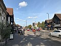
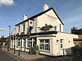
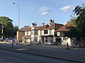
Locksbottom is a suburb of Orpington within the London Borough of Bromley, Greater London. Prior to 1965 it was within the historic county of Kent. It is located south of Bromley Common, west of Crofton, north-west of Farnborough, and east of Keston.